Buffalo, North Dakota

Last updated

Buffalo, North Dakota
BuffaloND OldStoneChurch.jpg
ND Cass County Buffalo.svg
Location of Buffalo, North Dakota
Coordinates: 46°55′09″N97°33′02″W / 46.91917°N 97.55056°W / 46.91917; -97.55056
CountryUnited States
State North Dakota
County Cass
Founded1878
Government
   Mayor Jim Jager
Area
[1]
  Total0.481 sq mi (1.246 km2)
  Land0.481 sq mi (1.246 km2)
  Water0.000 sq mi (0.000 km2)
Elevation
[2]
1,201 ft (366 m)
Population
 (2020) [3]
  Total195
  Estimate 
(2023) [4]
188
  Density405.41/sq mi (156.49/km2)
Time zone UTC–6 (Central (CST))
  Summer (DST) UTC–5 (CDT)
ZIP Code
58011
Area code 701
FIPS code 38-10420
GNIS feature ID1035946 [2]
Website buffalond.com

Buffalo is a city in Cass County, North Dakota, United States. The population was 195 at the 2020 census. [3] Buffalo was founded in 1878.

Contents

History

The first settlement at Buffalo was made in 1878. [5] A post office called Buffalo has been in operation since 1883. [6] The city took its name from Buffalo, New York. [7]

Geography

According to the United States Census Bureau, the city has a total area of 0.481 square miles (1.25 km2), all land. [1]

Demographics

Historical population
CensusPop.Note
1890 177
1900 21320.3%
1910 24113.1%
1920 26811.2%
1930 242−9.7%
1940 2451.2%
1950 2616.5%
1960 234−10.3%
1970 2413.0%
1980 226−6.2%
1990 204−9.7%
2000 2092.5%
2010 188−10.0%
2020 1953.7%
2023 (est.)188 [4] −3.6%
U.S. Decennial Census [8]
2020 Census [3]

2010 census

As of the 2010 census, there were 188 people, 92 households, and 52 families living in the city. The population density was 817.4 inhabitants per square mile (315.6/km2). There were 101 housing units at an average density of 439.1 per square mile (169.5/km2). The racial makeup of the city was 92.6% White, 0.5% African American, 1.6% Native American, 0.5% Asian, and 4.8% from two or more races.

There were 92 households, of which 19.6% had children under the age of 18 living with them, 50.0% were married couples living together, 3.3% had a female householder with no husband present, 3.3% had a male householder with no wife present, and 43.5% were non-families. 39.1% of all households were made up of individuals, and 19.5% had someone living alone who was 65 years of age or older. The average household size was 2.04 and the average family size was 2.73.

The median age in the city was 44 years. 19.7% of residents were under the age of 18; 6.4% were between the ages of 18 and 24; 24.5% were from 25 to 44; 24% were from 45 to 64; and 25.5% were 65 years of age or older. The gender makeup of the city was 53.2% male and 46.8% female.

2000 census

As of the 2000 census, there were 209 people, 96 households, and 57 families living in the city. The population density was 846.1 inhabitants per square mile (326.7/km2). There were 105 housing units at an average density of 425.1 per square mile (164.1/km2). The racial makeup of the city was 99.04% White and 0.96% Native American.

There were 96 households, out of which 22.9% had children under the age of 18 living with them, 55.2% were married couples living together, 1.0% had a female householder with no husband present, and 39.6% were non-families. 35.4% of all households were made up of individuals, and 26.0% had someone living alone who was 65 years of age or older. The average household size was 2.18 and the average family size was 2.83.

In the city, the population was spread out, with 22.0% under the age of 18, 2.9% from 18 to 24, 28.7% from 25 to 44, 20.6% from 45 to 64, and 25.8% who were 65 years of age or older. The median age was 43 years. For every 100 females, there were 99.0 males. For every 100 females age 18 and over, there were 91.8 males.

The median income for a household in the city was $31,250, and the median income for a family was $45,625. Males had a median income of $27,917 versus $18,333 for females. The per capita income for the city was $19,021. None of the families and 6.0% of the population were living below the poverty line, including no under eighteens and 8.7% of those over 64.

Education

Maple Valley School District operates public schools serving Buffalo. An elementary campus is in the town. [9] The former Buffalo High School is on the National Register of Historic Places.

Related Research Articles

<span class="mw-page-title-main">Bucyrus, North Dakota</span> City in North Dakota, United States

Bucyrus is a city in Adams County, North Dakota, United States. The population was 18 at the 2020 census.

<span class="mw-page-title-main">Leonard, North Dakota</span> City in North Dakota, United States

Leonard is a city in Cass County, North Dakota, United States. The population was 248 at the 2020 census. Leonard was founded in 1881.

<span class="mw-page-title-main">North River, North Dakota</span> City in North Dakota, United States

North River is a city in Cass County, North Dakota, United States. The population was 55 at the 2020 census. North River was founded in 1973. It is a suburb/bedroom community directly adjacent to the city of Fargo.

<span class="mw-page-title-main">Ellendale, North Dakota</span> City in North Dakota, United States

Ellendale is a city in Dickey County, North Dakota, United States. It is the capital city of Dickey County. The population was 1,125 at the 2020 census. Ellendale was founded in 1882. Ellendale is the home of Trinity Bible College, located on the former campus of the North Dakota State Normal and Industrial School and the Ellendale Opera House currently under renovation.

<span class="mw-page-title-main">Drake, North Dakota</span> City in North Dakota, United States

Drake is a city in McHenry County, North Dakota, United States. The population was 292 at the 2020 census. It is part of the Minot Micropolitan Statistical Area. Drake was founded in 1902 and named after Herman Drake, a settler.

<span class="mw-page-title-main">Golden Valley, North Dakota</span> City in North Dakota, United States

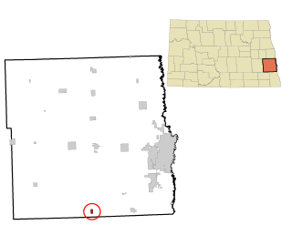
Golden Valley is a city in Mercer County, North Dakota, United States. The population was 182 at the 2020 census. Golden Valley was founded in 1913.

<span class="mw-page-title-main">McVille, North Dakota</span> City in North Dakota, United States

McVille is a city in Nelson County, North Dakota, United States. The population was 392 at the 2020 census. McVille was founded in 1906.

<span class="mw-page-title-main">Tolna, North Dakota</span> City in North Dakota, United States

Tolna is a city in Nelson County, North Dakota, United States. The population was 136 at the 2020 census. Tolna was founded in 1906.

<span class="mw-page-title-main">Neche, North Dakota</span> City in North Dakota, United States

Neche is a city in Pembina County, North Dakota, United States. It sits on the banks of the Pembina River. The population was 344 at the 2020 census.

<span class="mw-page-title-main">Sheldon, North Dakota</span> City in North Dakota, United States

Sheldon is a city in Ransom County, North Dakota, United States. The population was 95 at the 2020 census. Sheldon was founded in 1882.

<span class="mw-page-title-main">Buchanan, North Dakota</span> City in North Dakota, United States

Buchanan is a city in Stutsman County, North Dakota, United States. The population was 87 at the 2020 census. Buchanan was founded in 1887.

<span class="mw-page-title-main">Hatton, North Dakota</span> City in North Dakota, United States

Hatton is a city in Traill County, North Dakota, United States. The population was 712 at the 2020 census. Hatton was founded in 1882, and was named for Frank Hatton, then Assistant Postmaster General.

<span class="mw-page-title-main">Portland, North Dakota</span> City in North Dakota, United States

Portland is a city in Traill County, North Dakota, United States. The population was 578 at the 2020 census.

<span class="mw-page-title-main">Hoople, North Dakota</span> City in North Dakota, United States

Hoople is a city in Walsh County, North Dakota, United States. The population was 247 at the 2020 census. Hoople, named for early settler Alan Hoople, was founded in 1889. Hoople's nickname is "Tater Town."

<span class="mw-page-title-main">Buffalo Gap, South Dakota</span> Town in South Dakota, United States

Buffalo Gap is a town in Custer County, South Dakota, United States. The population was 131 at the 2020 census.

<span class="mw-page-title-main">Corsica, South Dakota</span> City in South Dakota, United States

Corsica is a city in Douglas County, South Dakota, United States. The population was 561 at the 2020 census.

<span class="mw-page-title-main">Stockholm, South Dakota</span> Town in South Dakota, United States

Stockholm is a town in Grant County, South Dakota, United States. The population was 102 at the 2020 census.

<span class="mw-page-title-main">Crooks, South Dakota</span> City in South Dakota, United States

Crooks is a city in Minnehaha County, South Dakota, United States and is a suburb of Sioux Falls. The population was 1,362 at the 2020 census. Crooks was named New Hope until 1904. The town's present name honors W. A. Crooks, a local politician.

<span class="mw-page-title-main">Davis, South Dakota</span> Town in South Dakota, United States

Davis is a town in Turner County, South Dakota, United States. The population was 54 at the 2020 census.

<span class="mw-page-title-main">Box Elder, South Dakota</span> City in South Dakota, United States

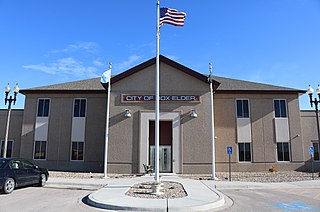
Box Elder is a city in Pennington and Meade counties in the State of South Dakota. The population was 11,746 at the 2020 census, making it the 10th most populous city in South Dakota. Ellsworth Air Force Base lies on the northeast side of the city.

References

  1. 1 2 "2023 U.S. Gazetteer Files". United States Census Bureau. Retrieved July 13, 2024.
  2. 1 2 U.S. Geological Survey Geographic Names Information System: Buffalo, North Dakota
  3. 1 2 3 "Explore Census Data". United States Census Bureau . Retrieved May 19, 2022.
  4. 1 2 "City and Town Population Totals: 2020–2023". United States Census Bureau. July 13, 2024. Retrieved July 13, 2024.
  5. Winser, Henry Jacob; Riley, William C. (1897). The Official Northern Pacific Railway Guide: For the Use of Tourists and Travelers Over the Lines of the Northern Pacific Railway and Its Branches. Northern Pacific Railway. p. 83.
  6. "Cass County". Jim Forte Postal History. Archived from the original on November 22, 2015. Retrieved October 22, 2015.
  7. Federal Writers' Project (1938). North Dakota, a Guide to the Northern Prairie State. WPA. p. 279. ISBN   978-1-62376-033-5.
  8. "Census of Population and Housing". United States Census Bureau. Retrieved June 4, 2015.
  9. Home. Maple Valley School District. Retrieved on July 17, 2018. "207 Broadway Tower City, ND 58071" and "Serving the communities of Buffalo, Fingal, Oriska and Tower City"