Briarwood, North Dakota

Last updated

Briarwood, North Dakota
Sign in Briarwood, North Dakota 8-1-2009.jpg
Sign in Briarwood
ND Cass County Briarwood.svg
Location of Briarwood, North Dakota
Coordinates: 46°47′13″N96°47′41″W / 46.78694°N 96.79472°W / 46.78694; -96.79472
CountryUnited States
State North Dakota
County Cass
Founded1973
Government
   Mayor John Adams
Area
[1]
  Total0.14 sq mi (0.37 km2)
  Land0.14 sq mi (0.37 km2)
  Water0.00 sq mi (0.00 km2)
Elevation
[2]
883 ft (269 m)
Population
 (2020) [3]
  Total57
  Estimate 
(2022) [4]
53
  Density398.60/sq mi (154.35/km2)
Time zone UTC-6 (Central (CST))
  Summer (DST) UTC-5 (CDT)
ZIP code
58104
Area code 701
FIPS code 38-09320
GNIS feature ID1035941 [2]

Briarwood is a city in Cass County, North Dakota, United States. The population was 57 at the 2020 census. [3] Briarwood was founded in 1973. It is a suburb directly adjacent to the city of Fargo.

Contents

Geography

According to the United States Census Bureau, the city has a total area of 0.15 square miles (0.39 km2), all land. [5]

Demographics

Historical population
CensusPop.Note
1980 47
1990 8887.2%
2000 78−11.4%
2010 73−6.4%
2020 57−21.9%
2022 (est.)53 [4] −7.0%
U.S. Decennial Census [6]
2020 Census [3]

2010 census

As of the census of 2010, there were 73 people, 25 households, and 21 families living in the city. The population density was 486.7 inhabitants per square mile (187.9/km2). There were 28 housing units at an average density of 186.7 per square mile (72.1/km2). The racial makeup of the city was 95.9% White and 4.1% Asian.

There were 25 households, of which 44.0% had children under the age of 18 living with them, 80.0% were married couples living together, 4.0% had a female householder with no husband present, and 16.0% were non-families. 12.0% of all households were made up of individuals, and 4% had someone living alone who was 65 years of age or older. The average household size was 2.92 and the average family size was 3.24.

The median age in the city was 44.8 years. 31.5% of residents were under the age of 18; 1.3% were between the ages of 18 and 24; 17.8% were from 25 to 44; 39.7% were from 45 to 64; and 9.6% were 65 years of age or older. The gender makeup of the city was 54.8% male and 45.2% female.

2000 census

As of the census of 2000, there were 78 people, 25 households, and 21 families living in the city. The population density was 353.8 inhabitants per square mile (136.6/km2). There were 26 housing units at an average density of 117.9 per square mile (45.5/km2). The racial makeup of the city was 98.72% White, and 1.28% from two or more races. Hispanic or Latino of any race were 3.85% of the population.

There were 25 households, out of which 56.0% had children under the age of 18 living with them, 76.0% were married couples living together, and 16.0% were non-families. 12.0% of all households were made up of individuals, and 4.0% had someone living alone who was 65 years of age or older. The average household size was 3.12 and the average family size was 3.48.

In the city, the population was spread out, with 38.5% under the age of 18, 1.3% from 18 to 24, 24.4% from 25 to 44, 29.5% from 45 to 64, and 6.4% who were 65 years of age or older. The median age was 38 years. For every 100 females, there were 116.7 males. For every 100 females age 18 and over, there were 128.6 males.

The median income for a household in the city was $180,508, and the median income for a family was $183,640. Males had a median income of $100,000 versus $76,250 for females. The per capita income for the city was $57,751. None of the population and none of the families were below the poverty line.

Related Research Articles

<span class="mw-page-title-main">Eagle, Idaho</span> City in Idaho, United States

Eagle is a city in Ada County, Idaho, United States, 10 miles (16 km) northwest of Boise. The population was 30,346 at the 2020 census.

<span class="mw-page-title-main">Hayesville, Iowa</span> City in Iowa, United States

Hayesville is a city in Keokuk County, Iowa, United States. The population was 41 at the time of the 2020 census.

<span class="mw-page-title-main">Webster, Iowa</span> City in Iowa, United States

Webster is a city in Keokuk County, Iowa, United States. The population was 94 at the time of the 2020 census.

<span class="mw-page-title-main">Briarwood, Kentucky</span> City in Kentucky, United States

Briarwood is a home rule-class city in Jefferson County, Kentucky, United States. The population was 435 at the 2010 census, down from 554 at the 2000 census.

<span class="mw-page-title-main">Lake Shore, Minnesota</span> City in Minnesota, United States

Lake Shore is a city in Cass County, Minnesota, United States. The population was 1,056 at the 2020 census. It is part of the Brainerd Micropolitan Statistical Area.

<span class="mw-page-title-main">Harding, Minnesota</span> City in Minnesota, United States

Harding is a city in Morrison County, Minnesota, United States, along the Platte River. The population was 123 at the 2020 census.

<span class="mw-page-title-main">Erhard, Minnesota</span> City in Minnesota, United States

Erhard is a city in Otter Tail County, Minnesota, United States. The population was 132 at the 2020 census.

<span class="mw-page-title-main">Urbank, Minnesota</span> City in Minnesota, United States

Urbank is a city in Otter Tail County, Minnesota, United States. The population was 52 at the 2020 census.

<span class="mw-page-title-main">St. Rosa, Minnesota</span> City in Minnesota, United States

Saint Rosa is a city in Stearns County, Minnesota, United States. The population was 68 at the 2010 census. It is part of the St. Cloud Metropolitan Statistical Area.

<span class="mw-page-title-main">Winchester, Missouri</span> City in Missouri, United States

Winchester is a city in St. Louis County, Missouri, United States. The population was 1,447 at the 2020 census.

<span class="mw-page-title-main">Clarkson Valley, Missouri</span> City in Missouri, United States

Clarkson Valley is a city in St. Louis County, Missouri, United States. The population was 2,609 at the 2020 census.

<span class="mw-page-title-main">Esmond, North Dakota</span> City in North Dakota, United States

Esmond is a city in Benson County, North Dakota, United States. The population was 91 at the 2020 census. Esmond was founded in 1901.

<span class="mw-page-title-main">Kramer, North Dakota</span> City in North Dakota, United States

Kramer is a city in Bottineau County, North Dakota, United States. The population was 24 at the 2020 census. Kramer was founded in 1905.

<span class="mw-page-title-main">Ayr, North Dakota</span> City in North Dakota, United States

Ayr is a city in Cass County, North Dakota, United States. The population was 11 at the 2020 census. Ayr was founded in 1883.

<span class="mw-page-title-main">North River, North Dakota</span> City in North Dakota, United States

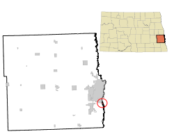
North River is a city in Cass County, North Dakota, United States. The population was 55 at the 2020 census. North River was founded in 1973. It is a suburb/bedroom community directly adjacent to the city of Fargo.

<span class="mw-page-title-main">Dunes City, Oregon</span> City in Oregon, United States

Dunes City is a city in Lane County, Oregon, United States. The population was 1,303 at the 2010 census.

<span class="mw-page-title-main">Crooks, South Dakota</span> City in South Dakota, United States

Crooks is a city in Minnehaha County, South Dakota, United States and is a suburb of Sioux Falls. The population was 1,362 at the 2020 census. Crooks was named New Hope until 1904. The town's present name honors W. A. Crooks, a local politician.

<span class="mw-page-title-main">East Renton Highlands, Washington</span> Census-designated place in Washington, United States

East Renton Highlands is a census-designated place (CDP) in King County, Washington, United States, located between Issaquah and Renton. The population was 11,937 at the 2020 census.

<span class="mw-page-title-main">Bancroft, West Virginia</span> Town in West Virginia, United States

Bancroft is a town in Putnam County, West Virginia, United States, along the Kanawha River. The population was 389 at the 2020 census. It is part of the Huntington–Ashland metropolitan area.

<span class="mw-page-title-main">Camden-on-Gauley, West Virginia</span> Town in West Virginia, United States

Camden-on-Gauley is a town in Webster County, West Virginia, United States, along the Gauley River. The population was 126 at the 2020 census.

References

  1. "ArcGIS REST Services Directory". United States Census Bureau. Retrieved September 20, 2022.
  2. 1 2 U.S. Geological Survey Geographic Names Information System: Briarwood, North Dakota
  3. 1 2 3 "Explore Census Data". United States Census Bureau . Retrieved November 29, 2023.
  4. 1 2 "City and Town Population Totals: 2020-2022". United States Census Bureau. November 29, 2023. Retrieved November 29, 2023.
  5. "US Gazetteer files 2010". United States Census Bureau. Archived from the original on February 20, 2011. Retrieved June 14, 2012.
  6. United States Census Bureau. "Census of Population and Housing" . Retrieved July 21, 2013.