Georgetown Township, Vermilion County, Illinois

Last updated

Georgetown Township
Map highlighting Georgetown Township, Vermilion County, Illinois.svg
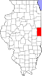
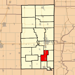
Location in Vermilion County
Coordinates: 40°00′17″N87°38′23″W / 40.00472°N 87.63972°W / 40.00472; -87.63972
Country United States
State Illinois
County Vermilion
Area
  Total
25.63 sq mi (66.4 km2)
  Land25.6 sq mi (66 km2)
  Water0.03 sq mi (0.078 km2)  0.12%
Elevation
669 ft (204 m)
Population
 (2020)
  Total
7,449
  Estimate 
(2016) [1]
7,538
  Density308.6/sq mi (119.2/km2)
Time zone UTC-6 (CST)
  Summer (DST) UTC-5 (CDT)
FIPS code 17-183-28976

Georgetown Township is a township in Vermilion County, Illinois, USA. As of the 2010 census, its population was 7,901 and it contained 3,573 housing units. [2]

Contents

Geography

According to the 2010 census, the township has a total area of 25.63 square miles (66.4 km2), of which 25.6 square miles (66 km2) (or 99.88%) is land and 0.03 square miles (0.078 km2) (or 0.12%) is water. [2]

Cities and towns

Extinct towns

Adjacent townships

Cemeteries

The township contains seven cemeteries: Dukes, Forest Park, Lithuanian, Pleasant Mound, Saints Peter and Paul, Sandusky and Searl.

Major highways

Demographics

Historical population
CensusPop.Note
2020 7,449 [3]
U.S. Decennial Census [4]

References

  1. "Population and Housing Unit Estimates" . Retrieved June 9, 2017.
  2. 1 2 "Population, Housing Units, Area, and Density: 2010 - County -- County Subdivision and Place -- 2010 Census Summary File 1". United States Census. Archived from the original on February 12, 2020. Retrieved May 28, 2013.
  3. "2020 Census Decennial Demographic and Housing Characteristics: Population by Place (Table P1)". Census Bureau Data. April 1, 2020. Archived from the original on September 24, 2025. Retrieved September 24, 2025.
  4. "Census of Population and Housing". Census.gov. Retrieved June 4, 2016.