The location was originally named Liggett's Grove in honor of John Liggett who built a lodging house in 1829. Liggett's cabin was located on the Hubbard Trail, an early trading route established by Gurdon Hubbard from Chicago to Danville. In 1833, this became the first state highway (now Illinois Route 1) and in 1914 was made part of the Dixie Highway.
In 1838, Alvan Gilbert purchased the Liggett farm, and the following year he became postmaster at the newly established post office. Rossville was incorporated as a village in August 1859.[3][4] Rossville and Ross Township were named after Jacob Ross, a settler in the area.
In February 2004, a fire broke out in the downtown business district and destroyed several of the historic buildings and antique shops for which Rossville has been known.[5]
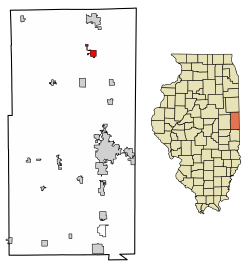
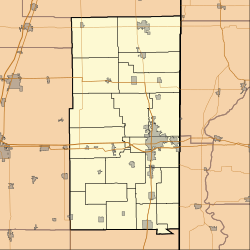
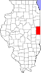
Geography
According to the 2010 census, Rossville has a total area of 1.4 square miles (3.63km2), all land.[6]
As of the census[7] of 2000, there were 1,317 people,532, and 341 families residing in the village. The population density was 905.1 inhabitants per square mile (349.5/km2). There were 596 housing units at an average density of 443.2 per square mile (171.1/km2). The racial makeup of the village was 97.78% White, 0.25% African American, 0.16% Native American, 0.08% Asian, 0.90% from other races, and 0.82% from two or more races. Hispanic or Latino of any race were 2.14% of the population.
There were 533 households, out of which 27.6% had children under the age of 18 living with them, 50.8% were married couples living together, 10.1% had a female householder with no husband present, and 36.0% were non-families. 32.3% of all households were made up of individuals, and 18.0% had someone living alone who was 65 years of age or older. The average household size was 2.28 and the average family size was 2.89.
In the village, the population was spread out, with 23.3% under the age of 18, 8.6% from 18 to 24, 25.2% from 25 to 44, 24.3% from 45 to 64, and 18.6% who were 65 years of age or older. The median age was 41 years. For every 100 females, there were 89.9 males. For every 100 females age 18 and over, there were 86.1 males.
The median income for a household in the village was $36,442, and the median income for a family was $43,882. Males had a median income of $32,083 versus $19,813 for females. The per capita income for the village was $16,794. About 7.8% of families and 9.8% of the population were below the poverty line, including 13.0% of those under age 18 and 8.8% of those age 65 or over.
Area attractions
Area attractions include the Rossville Historical Society Museum, the Rossville Railroad Depot Museum, Christman Park, and the Hubbard Trail Monument. South of Rossville are Historic Mann's Chapel (1857) and an original State Road Mile Marker from 1833.[8]
The Rossville Community Organization is active in hosting community events. These include; Free A-Train week in September, Drivin' The Dixie Days in June, and Christmas in the Village on the first weekend in December.
Rossville has hosted an annual truck and tractor pull event nine years running.[9][10] Held in Christman Park, there are typically three divisions for drivers to compete in including National Tractor Pull Association (NTPA), Illiana Pullers Association (IPA) and Local Classes.[10] NTPA classes are Grant National Super Stock Tractors, Light Pro Stock Tractors, Super Farm Tractors and Grand National Light Unlimited Modified Tractors.[10] IPA include Pro Farm Tractors, 2.6 Diesel Trucks, Farm Stock Tractors and N/A Tractors.[10] The tractor pull draws crowds and helps raise funds for FFA scholarships.[10]
Transportation
Rossville is located at the intersection of Illinois Route 1 and County Road 14, about 7 miles south of Hoopeston and about 15 miles north of the county seat of Danville. A railroad operated by CSX Transportation passes through the east side of town.[11]
↑Jones, Lottie E. (1911). History of Vermilion County, Illinois (volume 1). Chicago, Illinois: Pioneer Publishing Company. pp.223–224.
↑Stapp, Katherine; W. I. Bowman (1968). History Under Our Feet: The Story of Vermilion County, Illinois. Danville, Illinois: Interstate Printers and Publishers, Inc. p.46.
↑"Illinois Railroad Map"(PDF). Illinois Department of Transportation. January 2006. Archived from the original(PDF) on August 22, 2007. Retrieved September 23, 2007.
This page is based on this Wikipedia article Text is available under the CC BY-SA 4.0 license; additional terms may apply. Images, videos and audio are available under their respective licenses.