Ridge Farm, Illinois

Last updated
Ridge Farm
Village
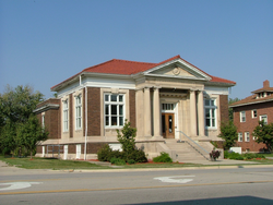
Ridge Farm Illinois Carnegie library.png
The Carnegie library in Ridge Farm
Vermilion County Illinois Incorporated and Unincorporated areas Ridge Farm Highlighted.svg
Location of Ridge Farm in Vermilion County, Illinois.
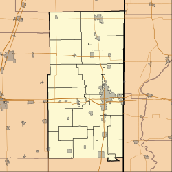
Location map of Vermilion County, Illinois.svg
Red pog.svg
Ridge Farm
Ridge Farm's location in Vermilion County
Coordinates: 39°53′45″N87°39′07″W / 39.89583°N 87.65194°W / 39.89583; -87.65194 Coordinates: 39°53′45″N87°39′07″W / 39.89583°N 87.65194°W / 39.89583; -87.65194 [1]
CountryUnited States
State Illinois
County Vermilion
Township Elwood
Area
[2]
  Total3.06 sq mi (7.92 km2)
  Land3.06 sq mi (7.92 km2)
  Water0.00 sq mi (0.00 km2)  0%
Elevation
[1]
705 ft (215 m)
Population
 (2020)
  Total940
  Density257.53/sq mi (99.42/km2)
Time zone UTC-6 (CST)
  Summer (DST) UTC-5 (CDT)
ZIP code
61870
Area code 217
FIPS code 17-63862
GNIS ID2399071 [1]
Website ridgefarmillinois.com

Ridge Farm is a village in Elwood Township, Vermilion County, Illinois, United States. It is part of the Danville, Illinois Metropolitan Statistical Area. The population was 940 at the 2020 census.

Contents

History

The town of Ridge Farm was named after Abraham Smith's Ridge Farm, located on a ridge of land running east to west through Elwood Township. The post office was established on May 17, 1841. [3]

Geography

Aerial view looking to the east, 2016 Ridge Farm, Illinois, USA aerial.png
Aerial view looking to the east, 2016

Ridge Farm is located at 39°53′49″N87°39′9″W / 39.89694°N 87.65250°W / 39.89694; -87.65250 (39.896836, -87.652588). [4] According to the 2010 census, Ridge Farm has a total area of 3.06 square miles (7.93 km2), all land. [5]

Demographics

Historical population
CensusPop.Note
1880 237
1890 757219.4%
1900 93323.2%
1910 9673.6%
1920 851−12.0%
1930 8884.3%
1940 8900.2%
1950 9051.7%
1960 894−1.2%
1970 1,01513.5%
1980 1,0968.0%
1990 939−14.3%
2000 912−2.9%
2010 882−3.3%
2020 787−10.8%
U.S. Decennial Census [6]

As of the census [7] of 2000, there were 912 people, 365 households, and 258 families residing in the village. The population density was 291.6 inhabitants per square mile (112.6/km2). There were 388 housing units at an average density of 124.1 per square mile (47.9/km2). The racial makeup of the village was 99.56% White, 0.11% Pacific Islander, and 0.33% from two or more races. Hispanic or Latino of any race were 0.44% of the population.

There were 365 households, out of which 31.0% had children under the age of 18 living with them, 58.1% were married couples living together, 9.3% had a female householder with no husband present, and 29.3% were non-families. 27.7% of all households were made up of individuals, and 15.6% had someone living alone who was 65 years of age or older. The average household size was 2.50 and the average family size was 3.03.

In the village, the population was spread out, with 27.3% under the age of 18, 7.0% from 18 to 24, 25.8% from 25 to 44, 24.9% from 45 to 64, and 15.0% who were 65 years of age or older. The median age was 38 years. For every 100 females, there were 96.1 males. For every 100 females age 18 and over, there were 86.8 males.

The median income for a household in the village was $33,333, and the median income for a family was $43,661. Males had a median income of $35,114 versus $24,083 for females. The per capita income for the village was $16,624. About 6.5% of families and 10.5% of the population were below the poverty line, including 10.0% of those under age 18 and 11.5% of those age 65 or over.

Notable person

Related Research Articles

<span class="mw-page-title-main">Panama, Illinois</span> Village in Illinois, United States

Panama is a village in Montgomery and Bond counties, Illinois, United States. The population was 337 at the 2020 census.

<span class="mw-page-title-main">Broadlands, Illinois</span> Village in Illinois, United States

Broadlands is a village in Champaign County, Illinois, along the East Branch of the Embarras River. The population was 316 at the 2020 census. Originally owned by the Sullivant family, Broadlands was, at over 70,000 acres (280 km2), one of the world's largest farms in the late 1860s. Broadlands was sold to John T. Alexander in 1866, and it was broken up upon his death in 1876 to pay his creditors.

<span class="mw-page-title-main">Pesotum, Illinois</span> Village in Illinois, United States

Pesotum is a village in Champaign County, Illinois, United States. The population was 551 at the 2010 census.

<span class="mw-page-title-main">Bulpitt, Illinois</span> Village in Illinois, United States

Bulpitt is a village in Christian County, Illinois, United States. The population was 212 at the 2020 census.

<span class="mw-page-title-main">Owaneco, Illinois</span> Village in Illinois, United States

Owaneco is a village in Christian County, Illinois, United States. The population was 209 at the 2020 census.

<span class="mw-page-title-main">Burr Ridge, Illinois</span> Village in Illinois, United States

Burr Ridge is a village in Cook and DuPage counties in the U.S. state of Illinois. A suburb of Chicago, it is among the wealthiest towns in Illinois and is locally known for its large, elegant mansions and luxury lifestyles. Per the 2020 census, the population was 11,192.

<span class="mw-page-title-main">East Hazel Crest, Illinois</span> Village in Illinois, United States

East Hazel Crest is a village in Cook County, Illinois, in the United States. It is a south suburb of Chicago. As of the 2020 census, the village population was 1,297.

<span class="mw-page-title-main">Forest View, Illinois</span> Village in Illinois, United States

Forest View is a village in Cook County, Illinois, United States. Per the 2020 census, the population was 792. It is primarily an industrial corridor adjacent to the Chicago neighborhood of Garfield Ridge, which is on the village's southern border.

<span class="mw-page-title-main">South Chicago Heights, Illinois</span> Village in Illinois, United States

South Chicago Heights is a village and a south suburb in Cook County, Illinois, United States. The population was 4,026 at the 2020 census.

<span class="mw-page-title-main">Thornton, Illinois</span> Village in Illinois, United States

Thornton is a village in Cook County, Illinois, United States and a south suburb of Chicago. The population was 2,386 at the 2020 census. Thornton is home to the Thornton Quarry, one of the largest quarries in the world.

<span class="mw-page-title-main">Chebanse, Illinois</span> Village in Illinois, United States

Chebanse is a village in Iroquois and Kankakee counties in the U.S. state of Illinois. The population was 1,044 at the 2020 census. The Kankakee County portion of Chebanse is included in the Kankakee-Bradley, Illinois Metropolitan Statistical Area.

<span class="mw-page-title-main">Elizabeth, Illinois</span> Village in Illinois, United States

Elizabeth is a village in Jo Daviess County, Illinois, United States. The population was 761 at the 2010 census.

<span class="mw-page-title-main">Old Mill Creek, Illinois</span> Village in Illinois, United States

Old Mill Creek is a village in Lake County, Illinois, United States. Per the 2020 census, the population was 162.

<span class="mw-page-title-main">Wadsworth, Illinois</span> Village in Illinois, United States

Wadsworth is a village in Lake County, Illinois, United States. Per the 2020 census, the population was 3,517. It is named after E. S. Wadsworth, who was a major stockholder for the Chicago, Milwaukee, St. Paul and Pacific Railroad, which passes through the village.

<span class="mw-page-title-main">Ashton, Illinois</span> Village in Illinois, United States

Ashton is a village in Lee County, Illinois, United States. The population was 972 at the 2010 census, down from 1,142 in 2000.

<span class="mw-page-title-main">Hettick, Illinois</span> Village in Illinois, United States

Hettick is a village in Macoupin County, Illinois, United States. The population was 149 at the 2020 census, down from 181 in 2010.

<span class="mw-page-title-main">Loami, Illinois</span> Village in Illinois, United States

Loami is a village in Sangamon County, Illinois, United States. The population was 745 at the 2010 census. It is part of the Springfield, Illinois Metropolitan Statistical Area. It is adjacent to the Nipper Wildlife Sanctuary, a parcel of tallgrass prairie replanted on the loam soil after which the village is named.

<span class="mw-page-title-main">Elwood, Illinois</span> Village in Illinois, United States

Elwood is a village in Will County, Illinois, United States. It is a far south suburb of Chicago. The population was 2,229 at the 2020 United States Census, down from 2,279 in 2010.

<span class="mw-page-title-main">Elwood, Kansas</span> City in Doniphan County, Kansas

Elwood is a city in Doniphan County, Kansas, United States, located west across the Missouri River from Saint Joseph, Missouri. As of the 2020 census, the population of the city was 1,125.

<span class="mw-page-title-main">Magnolia, Ohio</span> Village in Ohio, United States

Magnolia is a village in Carroll and Stark counties in the U.S. state of Ohio. The population was 1,013 at the time of the 2020 census. It is part of the Canton–Massillon metropolitan area.

References

  1. 1 2 3 U.S. Geological Survey Geographic Names Information System: Ridge Farm, Illinois
  2. "2020 U.S. Gazetteer Files". United States Census Bureau. Retrieved March 15, 2022.
  3. Callary, Edward (2009). Place Names of Illinois. Urbana, Illinois: University of Illinois Press. p. 296. ISBN   978-0-252-03356-8.
  4. "US Gazetteer files: 2010, 2000, and 1990". United States Census Bureau. 2011-02-12. Retrieved 2011-04-23.
  5. "G001 - Geographic Identifiers - 2010 Census Summary File 1". United States Census Bureau. Archived from the original on 2020-02-13. Retrieved 2015-12-25.
  6. "Census of Population and Housing". Census.gov. Retrieved June 4, 2015.
  7. "U.S. Census website". United States Census Bureau . Retrieved 2008-01-31.