Glaciofluvial deposits or Glacio-fluvial sediments consist of boulders, gravel, sand, silt and clay from ice sheets or glaciers. They are transported, sorted and deposited by streams of water. The deposits are formed beside, below or downstream from the ice. They include kames, kame terraces and eskers formed in ice contact and outwash fans and outwash plains below the ice margin. Typically the outwash sediment is carried by fast and turbulent fluvio-glacial meltwater streams, but occasionally it is carried by catastrophic outburst floods. Larger elements such as boulders and gravel are deposited nearer to the ice margin, while finer elements are carried farther, sometimes into lakes or the ocean. The sediments are sorted by fluvial processes. They differ from glacial till, which is moved and deposited by the ice of the glacier, and is unsorted.
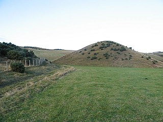
Esker in Einunndalsranden naturreservat, Hedmark, Norway
A subglacial megaflood may cut cavities into the base of the ice. As the flood dies down, sediment is deposited into these cavities to form cavity-fill drumlins in cavities aligned with the flow, ribbed terrain in cavities that cross the flow and hummocky terrain elsewhere.[1] Low, straight ridges as much as 10 metres (33ft) high may be formed where sediment fills in crevasses within the glacier or at its base.[1]
A kame is a short mound or ridge with steep sides of sands and gravels deposited from melted ice. Kames may be isolated or formed in groups. Some are formed at the base of a glacier by meltwater flowing down from the surface of the ice in a moulin, or from a water body within the glacier. Others are formed at the margin of the ice as small deltas.[2] Kame terraces are benches of sand and gravel that were deposited by braided rivers flowing between the side of the valley and the glacier's ice margin. Kame terraces on opposite sides of a valley glacier may be at different elevations.[3]
Sometimes stratified drift is deposited in the tunnels that run through or below the glacier. When the ice melts the drift is exposed as long, linear ridges of gravel called eskers. Some eskers formed in the Pleistocene ice sheets are several hundred kilometers long. Generally they range in length from a few hundred meters to a few kilometers.[4]
Ice contact deposits, including kames, kame plateaus and eskers, mostly consist of sand and gravel but may include beds of diamicton, silt and clay. Kames and kame plateaus usually have bases of laminated muds, and higher up have layers of increasingly coarse sands topped with gravel.[5]
Glaciolfluvial deposits are formed by outwash streams which flow through tunnels within or beneath a glacier.[4] The water mainly comes from melting, and may also come from rainfall or from run-off from ice-free slopes beside the glacier.[5] The streams have highly variable rates of flow depending on temperature, which in turn depends on the season, time of day and cloud cover. At times of high flow, the streams are under pressure.[4] Streams below the glacier may flow upslope, driven by pressure.[6]
The turbulent and fast-moving meltwater streams cause mechanical erosion through hydraulic action, cavitation and abrasion.[7] They may also dissolve and remove soluble chemicals from the abraded bedrock and debris below the glacier.[6] The streams pick up debris from below the glacier, and debris washed in from higher land beside the glacier. Usually they hold as much debris as they can carry when they leave the glacier.[4]
The large daily fluctuations in discharge affect sediment motion. The sediment is picked up and carried as the discharge rises, then deposited as discharge falls. Usually much of the sediment rolls or slides near the bed of the stream. During the highest discharge periods large boulders may be set in motion. There may also be high concentrations of suspended sediment in early summer, when discharge is highest.[8] Lakes or reservoirs below, within, on or beside the glacier may release massive outburst floods known as jökulhlaups.[9]
After emerging from its ice tunnel a meltwater stream spreads out and slows down, depositing debris. The channels become choked and the stream has to find new routes, which may result in a braided stream with channels separated by bars of gravel or sand.[4] The channel of the braided streams are very unstable due to high loads of sediment, fluctuations in discharge and lack of plants to anchor the banks.[10] The amount of material deposited is generally greatest near the end of the glacier, so the sediment will tend to slope down and thin out from that point.[4]
Outwash fans are deposits of sediment that fan out from the meltwater portal, with progressively finer sediment at greater distances from the portal. Fans may be deposited on land or in water.[3] A line of adjacent outwash fans from an ice sheet may form a ridge, or glaciofluvial moraine.[11] When many outwash streams flow from the ice front into a lowland area they form a broad sandur, or outwash plain.[10] A sandar may hold deposits that are tens of meters thick.[12] In mountainous regions the outwash streams are confined by valley sides and deposit thick layers of sediment in linear outwash plains called valley trains.[10] Terraces are formed when the streams grade down to lower levels and abandon higher and older outwash plains.[5]
The sediment is deposited in bedforms ranging in scale from sand ripples a few centimeters across to gravel bars several hundred meters long.[13] The sedimentary structures such as bedding, cross-bedding and clast imbrication are similar to those created by other types of stream.[12] Near the glacier the outwash plain is composed of long bars of coarse gravel with very variable grain size, with a few large channels between the bars. Further away there are transverse bars and a web of many braided channels. The sediment now includes gravel and sand, and the grains are rounder due to sorting and abrasion. Yet further away, as non-glacial streams join the outwash streams the flow forms shallow braided channels or meandering streams and deposits sand.[10] Glaciofluvial streams dominated by annual ice melting events may merge into a normal fluvial environment where non-glacial inflows are more important.[9]
Deposits from the subsiding waters of an outburst flood may be poorly sorted, with a wide range of grain sizes, and without distinct bedforms.[13] Other glaciofluvial sediments resemble sediments from non-glacial fluvial processes. They mainly consist of silt, sand and gravel with moderately rounded grain.[12] The sediment nearer the glacier typically is coarser than non-glacial sediment, ranging from boulders down to sand, but with little silt and clay since the water usually flows too fast to allow these fine particle to settle until it is a considerable distance from the glacier.[13] Generally the outwash deposits are finer further from the margin of the ice.[5] The deposits often have distinct layers due to the seasonal and episodic changes in stream flow.[1]
Outwash streams often flow into proglacial lakes, where they leave glaciolacustrine deposits. These mainly consist of silt and clay, with laminations on the millimeter scale. Sometimes they include varves, alternating coarser sediments in the summer periods of high melt discharge and finer sediment in the winter. When the stream terminates in the ocean it leaves glaciomarine sediments.[12] Outwash streams may form deltas where they enter lakes or the ocean.[10]
Kettles
Glaciofluvial deposits may surround and cover large blocks of ice. The debris may insulate the ice for several hundreds of years. Eventually the blocks of ice melt, leaving depressions called kettles, or kettle lakes if they fill with water.[4] Kettles are often associated with ice contact deposits. They may also form within sheet deposits, but are usually smaller than the ice contact kettles.[5]
Benn, D.I. (2009), "Glaciofluvial Sediments", in Gornitz, V. (ed.), Encyclopedia of Paleoclimatology and Ancient Environments, Encyclopedia of Earth Sciences Series, Dordrecht: Springer, doi:10.1007/978-1-4020-4411-3_98, retrieved 2021-01-16
Brannand, Tracy A. (January 2004), "Glacifluvial (glaciofluvial)", in Goudie, A. S. (ed.), Encyclopedia of Geomorphology, 1, A-I., Routledge, pp.459–465, retrieved 2021-01-16
Earle, Steven (September 2019), "Glacial Deposition", Physical Geology, retrieved 2021-01-16
A glacier is a persistent body of dense ice that is constantly moving under its own weight. A glacier forms where the accumulation of snow exceeds its ablation over many years, often centuries. Glaciers slowly deform and flow under stresses induced by their weight, creating crevasses, seracs, and other distinguishing features. They also abrade rock and debris from their substrate to create landforms such as cirques, moraines, or fjords. Glaciers form only on land and are distinct from the much thinner sea ice and lake ice that forms on the surface of bodies of water.
A moraine is any accumulation of unconsolidated debris, sometimes referred to as glacial till, that occurs in both currently and formerly glaciated regions, and that has been previously carried along by a glacier or ice sheet. It may consist of partly rounded particles ranging in size from boulders down to gravel and sand, in a groundmass of finely-divided clayey material sometimes called glacial flour. Lateral moraines are those formed at the side of the ice flow, and terminal moraines were formed at the foot, marking the maximum advance of the glacier. Other types of moraine include ground moraines and medial moraines.
Till or glacial till is unsorted glacial sediment.
An esker, eskar, eschar, or os, sometimes called an asar, osar, or serpent kame, is a long, winding ridge of stratified sand and gravel, examples of which occur in glaciated and formerly glaciated regions of Europe and North America. Eskers are frequently several kilometres long and, because of their uniform shape, look like railway embankments.
Glaciology is the scientific study of glaciers, or more generally ice and natural phenomena that involve ice.
In geography and geology, fluvial processes are associated with rivers and streams and the deposits and landforms created by them. When the stream or rivers are associated with glaciers, ice sheets, or ice caps, the term glaciofluvial or fluvioglacial is used.
Landforms are categorized by characteristic physical attributes such as their creating process, shape, elevation, slope, orientation, rock exposure, and soil type.
A kame delta is a glacial landform formed by a stream of melt water flowing through or around a glacier and depositing material, known as kame deposits. Upon entering a proglacial lake at the end (terminus) of a glacier, the river/stream deposit these sediments. This landform can be observed after the glacier has melted and the delta's asymmetrical triangular shape is visible. Once the glacier melts, the edges of the delta may subside as ice under it melts. Glacial till is deposited on the lateral sides of the delta, as the glacier melts.
A kame is a glacial landform, an irregularly shaped hill or mound composed of sand, gravel and till that accumulates in a depression on a retreating glacier, and is then deposited on the land surface with further melting of the glacier. Kames are often associated with kettles, and this is referred to as kame and kettle topography. The word kame is a variant of comb, which has the meaning "crest" among others. The geological term was introduced by Thomas Jamieson in 1874.
A kettle is a depression/hole in an outwash plain formed by retreating glaciers or draining floodwaters. The kettles are formed as a result of blocks of dead ice left behind by retreating glaciers, which become surrounded by sediment deposited by meltwater streams as there is increased friction. The ice becomes buried in the sediment and when the ice melts, a depression is left called a kettle hole, creating a dimpled appearance on the outwash plain. Lakes often fill these kettles; these are called kettle hole lakes. Another source is the sudden drainage of an ice-dammed lake. When the block melts, the hole it leaves behind is a kettle. As the ice melts, ramparts can form around the edge of the kettle hole. The lakes that fill these holes are seldom more than 10 m (33 ft) deep and eventually become filled with sediment. In acid conditions, a kettle bog may form but in alkaline conditions, it will be kettle peatland.
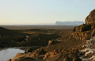
An outwash plain, also called a sandur, sandr or sandar, is a plain formed of glacial sediments deposited by meltwater outwash at the terminus of a glacier. As it flows, the glacier grinds the underlying rock surface and carries the debris along. The meltwater at the snout of the glacier deposits its load of sediment over the outwash plain, with larger boulders being deposited near the terminal moraine, and smaller particles travelling further before being deposited. Sandurs are common in Iceland where geothermal activity accelerates the melting of ice flows and the deposition of sediment by meltwater.
Glacial landforms are landforms created by the action of glaciers. Most of today's glacial landforms were created by the movement of large ice sheets during the Quaternary glaciations. Some areas, like Fennoscandia and the southern Andes, have extensive occurrences of glacial landforms; other areas, such as the Sahara, display rare and very old fossil glacial landforms.
The Oak Ridges Moraine is a geological landform that runs east-west across south central Ontario, Canada. It developed about 12,000 years ago, during the Wisconsin glaciation in North America. A complex ridge of sedimentary material, the moraine is known to have partially developed under water. The Niagara Escarpment played a key role in forming the moraine in that it acted as a dam for glacial meltwater trapped between it and two ice lobes.
A terminal moraine, also called end moraine, is a type of moraine that forms at the snout (edge) of a glacier, marking its maximum advance. At this point, debris that has accumulated by plucking and abrasion, has been pushed by the front edge of the ice, is driven no further and instead is deposited in a heap. Because the glacier acts very much like a conveyor belt, the longer it stays in one place, the greater the amount of material that will be deposited. The moraine is left as the marking point of the terminal extent of the ice.
Fluvio refers to things related to rivers and glacial refers to something that is of ice. Fluvio-glacial refers to the meltwater created when a glacier melts. Fluvio-glacial processes can occur on the surface and within the glacier. The deposits that happen within the glacier are revealed after the entire glacier melts or partially retreats. Fluvio-glacial landforms and erosional surfaces include: outwash plains, kames, kame terraces, kettle holes, eskers, varves, and proglacial lakes.
An outwash fan is a fan-shaped body of sediments deposited by braided streams from a melting glacier. Sediment locked within the ice of the glacier, gets transported by the streams of meltwater, and deposits on the outwash plain, at the terminus of the glacier. The outwash, the sediment transported and deposited by the meltwater and that makes up the fan, is usually poorly sorted due to the short distance traveled before being deposited.
A tunnel valley is a U-shaped valley originally cut under the glacial ice near the margin of continental ice sheets such as that now covering Antarctica and formerly covering portions of all continents during past glacial ages. They can be as long as 100 km (62 mi), 4 km (2.5 mi) wide, and 400 m (1,300 ft) deep.
A subaqueous fan is a fan-shaped deposit formed beneath water, and are commonly related to glaciers and crater lakes.
The glacial history of Minnesota is most defined since the onset of the last glacial period, which ended some 10,000 years ago. Within the last million years, most of the Midwestern United States and much of Canada were covered at one time or another with an ice sheet. This continental glacier had a profound effect on the surface features of the area over which it moved. Vast quantities of rock and soil were scraped from the glacial centers to its margins by slowly moving ice and redeposited as drift or till. Much of this drift was dumped into old preglacial river valleys, while some of it was heaped into belts of hills at the margin of the glacier. The chief result of glaciation has been the modification of the preglacial topography by the deposition of drift over the countryside. However, continental glaciers possess great power of erosion and may actually modify the preglacial land surface by scouring and abrading rather than by the deposition of the drift.
The glacial series refers to a particular sequence of landforms in Central Europe that were formed during the Pleistocene glaciation beneath the ice sheets, along their margins and on their forelands during each glacial advance.
This page is based on this Wikipedia article Text is available under the CC BY-SA 4.0 license; additional terms may apply. Images, videos and audio are available under their respective licenses.