Goose Creek Oil Field

Last updated
Goose Creek Field, c. 1919 GooseCreekFieldPart1919.jpg
Goose Creek Field, c. 1919

The Goose Creek Oil Field is a large oil field in Baytown, Texas, on Galveston Bay. Discovered in 1903, and reaching maximum production in 1918 after a series of spectacular gushers, it was one of the fields that contributed to the Texas Oil Boom of the early 20th century. The field was also the location of the first offshore wells in Texas, [1] and the second group of offshore wells in the United States. Consequences of the development of the Goose Creek field included an economic boom and associated influx of workers, the founding and fast growth of Baytown, and the building of the adjacent Baytown Refinery, which is now the 2nd largest oil refinery in the United States with a capacity of 584,000 barrels per day. [1] The field remains active, having produced over 150 million barrels (24,000,000 m3) of oil in its 100-year history. [2] [3]

Contents

The Goose Creek field is also the first place where subsidence of overlying terrain was attributed to the removal of oil from underneath. [4] On the Goose Creek field, subsidence has damaged houses, roads, and businesses, and much of the oil field that was on land in the early years of its development is now submerged in Tabbs Bay. Subsidence-induced motion along faults on the field also caused the only earthquake of local origin ever felt in the Houston area. [5]

Setting

The Goose Creek field is located along the northern shoreline of Tabbs Bay, an arm of Galveston Bay, at the point where Goose Creek exits to the sea. It is directly south of the city of Baytown, and about 25 miles (40 km) east of downtown Houston. Elevations on the field range from approximately 30 feet (9.1 m) at the highest well locations next to developed parts of Baytown, on the north side of the field, to submerged and partially submerged areas within Tabbs Bay itself. Much of the field is close to sea level. The total productive area of the field, including the submerged portion, is approximately 3,470 acres (14.0 km2). [6]

Alexander Drive, a spur of Texas State Highway 146, runs through the field. West of Goose Creek it rejoins Highway 146 to go over Tabbs Bay on the Fred Hartman Bridge.

Geology

The oil field is an accumulation of petroleum in sediment overlying a deep salt dome, one of several such fields in the Gulf of Mexico region. It was the first oil field to be found in a deep rather than a shallow salt dome, and its discovery led to the search for others like it; the finds that resulted were some of the largest oil fields in the United States. [1] The sedimentary layers over the dome are themselves arched into a shape conforming to the underlying dome, so the structure forms a perfect trap for hydrocarbons which would otherwise migrate to the surface. The field contains 30 separate pools or producing horizons, ranging in depth from 800 to 4,500 feet (1,400 m). [7] The oil-bearing strata under the salt dome consist of porous sands with some interspersed clay. [8]

The Goose Creek field is the first place where subsidence of the land over the oil field was definitively attributed to the extraction of petroleum. Subsidence over the Goose Creek field is well documented and particularly dramatic; parts of the field which were once above-water are now wholly or partially submerged, and the area of subsidence almost exactly conforms to the boundary of the productive region. The connection between extraction and subsidence was first recognized by geologists Wallace Everette Pratt and D.W. Johnson, who published their findings in a 1926 paper. By this year, after about ten years of active pumping, most of the productive area of the field had subsided three feet, and the submerging of the facilities had already become obvious to field operators. [6] [9] [10]

Along with the subsidence, surface faulting has been observed, and motion along these faults – although minimal compared to motion along faults in areas in which the seismic activity is due to tectonic forces – has been sufficient to damage buildings and be felt in the local area. One of the faults in the Goose Creek area, first observed in 1925, shows a vertical displacement of 0.4 meter, along a length of over 700 meters. [8]

Subsidence of land due to either oil or groundwater extraction is now widely recognized, and the Gulf Coast is one of many places in the world in which it has become a serious problem. In the present day, oil fields underneath sensitive areas, such as cities, are usually re-pressurized with water or gas to prevent the land above them from collapsing into the vacated space.

History, operations, and production

Bubbles of methane gas coming up in the shallow water along the shoreline of Galveston Bay alerted early prospectors in 1903 to the possibility of an oil field in the area. The first attempts to develop the field followed shortly, but none of the wells produced economic quantities of oil; indeed it was not until 1908 that oil was found at all, and the Producers Oil Company drilled 20 separate times in a failed attempt to create a well that flowed sufficiently to turn a profit. The American Petroleum Company had better luck, and their 8,000-barrel (1,300 m3)-per-day gusher on August 23, 1916 brought in the field. The subsequent fast influx of workers and equipment engendered a pair of boomtowns – Pelly and Goose Creek – adjacent to the field. In 1917 Ross S. Sterling, president of Humble Oil Company, chose to build a refinery on vacant land just northwest of the oil field, reorganizing his firm as the Humble Oil and Refining Company in order to accomplish the task. Humble Oil would go on to become Exxon, and the Baytown Refinery would eventually become the largest refinery in the United States. In addition, in 1919 Sterling arranged for the construction of Baytown on land adjacent to his new refinery. [11]

High oil prices also fueled the field's fast development. The First World War had caused a run-up in the price, which reached $1.35 per barrel by 1917. During that year the average well was producing over 1,000 barrels per day (160 m3/d), and the biggest gusher also occurred during 1917 – a well drilled by the Simms-Sinclair Company which spewed 35,000 barrels per day (5,600 m3/d), remaining out of control for several days. [1]

The Goose Creek Oil Field was the location of the first offshore wells in Texas. [11] They were drilled in shallow water from piers like the ones in on the Summerland field in Summerland, California twenty years before, which were the first in the world. [12] Due to subsidence many of the wells which were originally on land are now wholly or partially submerged.

Because of the sinking of the land containing the field, the State of Texas sued the Humble Oil Co. for rights to the field, as technically the field had ceased to be on land but had joined the state water bottomlands, which were not subject to private ownership. Along with title to the field and the various private parcels within it, the State sought to collect the revenues from oil and gas produced since the land went underwater. The State lost the suit, with the court ruling that the subsidence was caused by the extraction of oil, and was therefore an "act of Man" rather than a natural event. Humble Oil continued to produce from the field. [5] [8]

Parts of the field have subsided nine feet from the original ground surface elevation since production began, while subsidence in adjacent Baytown has reached approximately six feet. Not all of the subsidence in the field and adjacent areas is due to oil withdrawal; some is from pumping of groundwater from water wells. [5]

Peak production of the field had been reached by 1918, before the street grid for Baytown had even been drawn up. In that year the field produced 8,923,635 barrels (1,418,744.6 m3) of oil (more than the current estimated recoverable reserve). Some of the infrastructure improvements built during this year were the railroad connecting the oil field to the site of the future refinery, and pipelines crossing under the bay connecting storage tanks to the mainland. [1] On May 24, 1919, a tropical storm destroyed over 1,450 of the flimsy wooden oil derricks erected on the field. [13] After the production peak in 1918, field output began a slow decline, dropping from the high of 25,000 barrels per day (4,000 m3/d) in 1918 to only 1,100 in 1943. Production increased again in the 1960s with the development of water injection technologies, but then began falling off as the field became depleted. [7]

Panorama of the field after the 1919 hurricane destroyed over 1,400 oil derricks GooseCreek19196a14590r.jpg
Panorama of the field after the 1919 hurricane destroyed over 1,400 oil derricks

The field's major operators in 1984 were Exxon, Chevron, Mobil, Monsanto, Coastal, and Enderli Oil. Many of the major oil companies began divesting their onshore operations in the U.S. around this time, selling them to independents, as opportunities overseas became more attractive. The field changed hands several times, going to Wood Energy Corp. in 1996, and then to Texas American Resources in 1999. They operated the field until 2006, at which time Bakersfield, California-based Foothills-Resources bought the field. [7] Foothills immediately began a remapping and 3D-seismic survey program to identify new development opportunities. At this time the daily production from the field was around 820 barrels (130 m3) of oil per day; Foothills-Resources claimed that the field retained 5.1 million barrels (810,000 m3) of proven reserves. [2] In late 2007 they put in new wells, but the entire field was shut down for two weeks in September 2008 due to Hurricane Ike, the eye of which passed directly over the field, and destroyed or damaged considerable oil and gas infrastructure in the northwestern Gulf of Mexico. In spite of the direct hit by Ike, and the field being right at sea level or in shallow water, subject to storm surge, little long-term damage occurred; nevertheless the field was inoperative for two weeks. [14] On February 11, 2009, Foothills filed for Chapter 11 bankruptcy in the bankruptcy court for Delaware. [15]

Related Research Articles

<span class="mw-page-title-main">History of the petroleum industry in the United States</span>

The history of the petroleum industry in the United States goes back to the early 19th century, although the indigenous peoples, like many ancient societies, have used petroleum seeps since prehistoric times; where found, these seeps signaled the growth of the industry from the earliest discoveries to the more recent.

<span class="mw-page-title-main">Spindletop</span> Oil field in southern Beaumont, Texas, United States

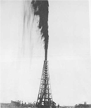
Spindletop is an oil field located in the southern portion of Beaumont, Texas, in the United States. The Spindletop dome was derived from the Louann Salt evaporite layer of the Jurassic geologic period. On January 10, 1901, a well at Spindletop struck oil. The Spindletop gusher blew for 9 days at a rate estimated at 100,000 barrels (16,000 m3) of oil per day. Gulf Oil and Texaco, now part of Chevron Corporation, were formed to develop production at Spindletop. The Spindletop discovery led the United States into the oil age. Prior to Spindletop, oil was primarily used for lighting and as a lubricant. Because of the quantity of oil discovered, burning petroleum as a fuel for mass consumption suddenly became economically feasible.

<span class="mw-page-title-main">Baytown, Texas</span> City in Texas, United States

Baytown is a city in the U.S. state of Texas, within Harris and Chambers counties. Located in the Houston–The Woodlands–Sugar Land metropolitan statistical area, it lies on the northern side of the Galveston Bay complex near the outlets of the San Jacinto River and Buffalo Bayou. It is the sixth-largest city within this metropolitan area and seventh largest community. Major highways serving the city include State Highway 146 and Interstate 10. At the 2020 U.S. census, Baytown had a population of 83,701, and it had an estimated population of 78,393 in 2021.

<span class="mw-page-title-main">Wallace Pratt</span> American geologist (1885–1981)

Wallace Everette Pratt (1885–1981) was a pioneer American petroleum geologist. He is also notable for helping establish Guadalupe Mountains National Park through his donation of McKittrick Canyon. He is also notable for his marriage to Iris Calderhead, prominent advocate for sex equality and his classmate from the University of Kansas, in 1931.

<span class="mw-page-title-main">Galveston Bay</span> Estuary bay near Houston on the Texas Gulf Coast

Galveston Bay is a bay in the western Gulf of Mexico along the upper coast of Texas. It is the seventh-largest estuary in the United States, and the largest of seven major estuaries along the Texas Gulf Coast. It is connected to the Gulf of Mexico and is surrounded by sub-tropical marshes and prairies on the mainland. The water in the bay is a complex mixture of sea water and fresh water, which supports a wide variety of marine life. With a maximum depth of about 10 feet (3 m) and an average depth of only 6 feet (2 m), it is unusually shallow for its size.

<span class="mw-page-title-main">East Texas Oil Field</span> Oil and gas field in east Texas

The East Texas Oil Field is a large oil and gas field in east Texas. Covering 140,000 acres (57,000 ha) and parts of five counties, and having 30,340 historic and active oil wells, it is the second-largest oil field in the United States outside Alaska, and first in total volume of oil recovered since its discovery in 1930. Over 5.42 billion barrels (862,000,000 m3) of oil have been produced from it to-date. It is a component of the Mid-continent oil province, the huge region of petroleum deposits extending from Kansas to New Mexico to the Gulf of Mexico.

<span class="mw-page-title-main">Blowout (well drilling)</span> Uncontrolled release of crude oil and/or natural gas from a well

A blowout is the uncontrolled release of crude oil and/or natural gas from an oil well or gas well after pressure control systems have failed. Modern wells have blowout preventers intended to prevent such an occurrence. An accidental spark during a blowout can lead to a catastrophic oil or gas fire.

<span class="mw-page-title-main">Lakeview Gusher</span>

The Lakeview Gusher was an eruption of hydrocarbons from a pressurized oil well in the Midway-Sunset Oil Field in Kern County, California, in 1910. It created the largest accidental oil spill in history, lasting 18 months and releasing an estimated 9 million barrels of crude oil.

<span class="mw-page-title-main">Geography of Houston</span> Geogrsphic aspects of Texas most populous city

Houston, the most populous city in the Southern United States, is located along the upper Texas Gulf Coast, approximately 50 miles (80 km) northwest of the Gulf of Mexico at Galveston. The city, which is the ninth-largest in the United States by area, covers 601.7 square miles (1,558 km2), of which 579.4 square miles (1,501 km2), or 96.3%, is land and 22.3 square miles (58 km2), or 3.7%, is water.

<span class="mw-page-title-main">Galveston Bay Area</span> Region in Texas, United States of America

The Galveston Bay Area, also known as Bay Area Houston or simply the Bay Area, is a region that surrounds the Galveston Bay estuary of Southeast Texas in the United States, within Houston–The Woodlands–Sugar Land metropolitan area. Normally the term refers to the mainland communities around the bay and excludes Galveston as well as most of Houston.

<span class="mw-page-title-main">San Jacinto Battleground State Historic Site</span> United States historic place

The San Jacinto Battleground State Historic Site includes the location of the Battle of San Jacinto and the museum ship USS Texas. It is located off the Houston Ship Channel in unincorporated Harris County, Texas near the city of Houston. The site was designated a National Historic Landmark in 1960.

<span class="mw-page-title-main">Midway-Sunset Oil Field</span> Oil field in Kern County, San Joaquin Valley, California

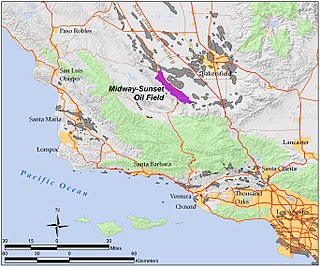
The Midway-Sunset Oil Field is a large oil field in Kern County, San Joaquin Valley, California in the United States. It is the largest known oilfield in California and the third largest in the United States.

<span class="mw-page-title-main">Coalinga Oil Field</span> Oil field in Fresno County, California, United States

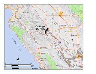
The Coalinga Oil Field is a large oil field in western Fresno County, California, in the United States. It surrounds the town of Coalinga, about halfway between Los Angeles and San Francisco, to the west of Interstate 5, at the foot of the Diablo Range. Discovered in the late 19th century, it became active around 1890, and is now the eighth-largest oil field in California, with reserves totaling approximately 58 million barrels (9,200,000 m3), and over 1,600 active oil wells. The principal operators on the field, as of 2008, were Chevron Corp. and Aera Energy LLC.

<span class="mw-page-title-main">Buena Vista Oil Field</span> Historic site in miles N of McKittrick, California

The Buena Vista Oil Field, formerly the Naval Petroleum Reserve No. 2 (NPR-2) is a large oil field in Kern County, San Joaquin Valley, California in the United States. Discovered in 1909, and having a cumulative production of approximately 667 million barrels (106,000,000 m3), it is the tenth-largest oil field in California. As of year end 2006 the field had a total reserve of only about one percent of its original oil, and having produced a mere 713,000 barrels (113,400 m3). Since, the field has gone through a revitalization. Crimson Resources initiated a waterflood in the Etchegoin Formation, saw good response and sold the asset to Occidental Petroleum. CRC continued the development of the waterflood, but also tested the viability of the Monterey Formation. The Monterey Formation at Buena Vista has proven to be a viable target and is currently being developed.

<span class="mw-page-title-main">Lost Hills Oil Field</span> Kern County, California oilfield

The Lost Hills Oil Field is a large oil field in the Lost Hills Range, north of the town of Lost Hills in western Kern County, California, in the United States.

<span class="mw-page-title-main">Yates Oil Field</span>

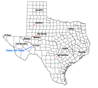
The Yates Oil Field is a giant oil field in the Permian Basin of west Texas. Primarily in extreme southeastern Pecos County, it also stretches under the Pecos River and partially into Crockett County. Iraan, on the Pecos River and directly adjacent to the field, is the nearest town. The field has produced more than one billion barrels of oil, making it one of the largest in the United States, and in 1998 it remains productive, though at a diminished rate. Since fracking has exploded in the Permian Basin, the Yates field has seen very heavy activity in the past three years. Estimated recoverable reserves are still approximately one billion barrels, which represents approximately 50% of the original oil in place (OOIP).

<span class="mw-page-title-main">History of the Galveston Bay Area</span> Aspect of history surrounding the Galveston Bay Area

For a period of over 7000 years, humans have inhabited the Galveston Bay Area in what is now the United States. Through their history the communities in the region have been influenced by the once competing sister cities of Houston and Galveston, but still have their own distinct history. Though never truly a single, unified community, the histories of the Bay Area communities have had many common threads.

<span class="mw-page-title-main">Orcutt Oil Field</span> Oil field in California, US

The Orcutt Oil Field is a large oil field in the Solomon Hills south of Orcutt, in Santa Barbara County, California, United States. Discovered in 1901 by William Warren Orcutt, it was the first giant field to be found in Santa Barbara County, and its development led to the boom town of Orcutt, now the major unincorporated southern suburb of Santa Maria. With a cumulative production in 2008 of 870,000 barrels (138,000 m3) of oil, it is the largest onshore producing field in Santa Barbara County.

<span class="mw-page-title-main">Texas oil boom</span> Period of change and economic growth in Texas

The Texas oil boom, sometimes called the gusher age, was a period of dramatic change and economic growth in the U.S. state of Texas during the early 20th century that began with the discovery of a large petroleum reserve near Beaumont, Texas. The find was unprecedented in its size (worldwide) and ushered in an age of rapid regional development and industrialization that has few parallels in U.S. history. Texas quickly became one of the leading oil-producing states in the U.S., along with Oklahoma and California; soon the nation overtook the Russian Empire as the top producer of petroleum. By 1940 Texas had come to dominate U.S. production. Some historians even define the beginning of the world's Oil Age as the beginning of this era in Texas.

<span class="mw-page-title-main">Spindletop-Gladys City Boomtown Museum</span> History Museum in Beaumont, TX

The Spindletop-Gladys City Boomtown Museum is located in Beaumont, Texas, to commemorate the discovery of oil at the Spindletop Hill salt dome in Beaumont on Jan. 10, 1901. The discovery sparked an oil boom in Texas that continues today. Along with a gift shop with commemorative gifts, the museum features historical, period reenactments by area performers. A replica of the wooden oil derricks that once dotted the landscape of Spindletop Hill in the early 1900s has been erected near the museum. For special occasions and anniversaries, the museum staff “blows the gusher” with a plume of water and provides a historical narrative and sound effects to simulate the discovery of oil at Spindletop.

References

  1. 1 2 3 4 5 "Goose Creek Oilfield". Handbook of Texas Online. Retrieved 2009-12-24.
  2. 1 2 "Acquisition of Goose Creek field: 2006 press release" (PDF). Archived from the original (PDF) on 2008-11-20. Retrieved 2009-12-30.
  3. Exxon Mobil Baytown Area
  4. Berman, Arthur E. "The Debate Over Subsidence in Coastal Louisiana and Texas". Houston Geological Society. Archived from the original on 2011-07-16. Retrieved 2009-12-27.
  5. 1 2 3 Garcia, T.D. "Subsidence and Surface Faulting at San Jacinto Monument, Goose Creek Oil Field, and Baytown, Texas". Field Trip Guidebook on Environmental Impact of Clays along the Upper Texas Coast. Prepared by Theron D. Garcia, Douglas W. Ming, and Lisa Kay Tuck for the Clay Minerals Society, 28th Annual Meeting. Held October 5–10, 1991, in Houston, TX. pp. A33-A44. Hosted with National Aeronautics and Space Administration Lyndon B. Johnson Space Center, and the Lunar and Planetary Institute.
  6. 1 2 Holzer, T.L.; Bluntzer, R.L. (1984). "Land subsidence near oil and gas-fields, Houston, Texas" (PDF). Ground Water. 22 (4): 450–459. Bibcode:1984GrWat..22..450H. doi:10.1111/j.1745-6584.1984.tb01416.x. Archived from the original (PDF) on 26 July 2011. Retrieved 25 December 2009.
  7. 1 2 3 Field history, from Foothills: p. 12 [ permanent dead link ]
  8. 1 2 3 Yerkes, R.F.; Castle, R.O., Surface Deformation Associated with Oil and Gas Field Operations in the United States, Menlo Park, California: United States Geological Survey, pp. 55–65
  9. Holzer, T.L. "The history of the aquitard-drainage model", in Borchers, J.W., ed., Land subsidence: Case histories and current research: Association of Engineering Geologists Special Publication no. 8, p. 7-16. 1998.
  10. Pratt, W.E., and D.W. Johnson, Local subsidence of the Goose Creek oil field, J. Geol., 34 (7), 577-590, 1926.
  11. 1 2 "Baytown, Texas". Handbook of Texas Online. Retrieved 2009-12-24.
  12. Wilder, Robert J. (1998). Listening to the sea: the politics of improving environmental protection . Pittsburgh, Pennsylvania: University of Pittsburgh Press. p.  30. ISBN   0-8229-5663-2.
  13. Library of Congress Photo Collection description
  14. "FOOTHILLS RESOURCES INC, Form 10-K, Annual Report, Filing Date May 11, 2009". secdatabase.com. Retrieved May 17, 2018.
  15. "Foothills Resources bankruptcy filing" (PDF). Archived from the original (PDF) on 2009-03-06. Retrieved 2009-12-30.

Further reading

29°42′36.06″N94°58′59.13″W / 29.7100167°N 94.9830917°W / 29.7100167; -94.9830917