
A National Historic Landmark (NHL) is a building, district, object, site, or structure that is officially recognized by the United States government for its outstanding historical significance. Only some 2,500, or roughly three percent, of over 90,000 places listed on the country's National Register of Historic Places are recognized as National Historic Landmarks.

The National Register of Historic Places in the United States is a register including buildings, sites, structures, districts, and objects. The Register automatically includes all National Historic Landmarks as well as all historic areas administered by the U.S. National Park Service. Since its introduction in 1966, more than 90,000 separate listings have been added to the register.
Winter Island is an island connected by a causeway to Salem Neck in Salem, Massachusetts. It is about 45 acres (18 ha) in size, and is bounded by Smith Pool to the northwest, Cat Cove to the west, Salem Channel to the south and east, and Juniper Cove to the north. The island has about a dozen residences at the north end and one road, Winter Island Road. The Plummer Home for Boys sits on 18 acres (7.3 ha) of land on the northeastern shore. The balance of the island is Winter Island Marine Park. The entire island was added to the National Register of Historic Places as Winter Island Historic District and Archeological District in 1994.

The National Register of Historic Places is a United States federal official list of places and sites considered worthy of preservation. In the state of Massachusetts, there are over 4,300 listings, representing about 5% of all NRHP listings nationwide and the second-most of any U.S. state, behind only New York. Listings appear in all 14 Massachusetts counties.

The Sankaty Head Light is a lighthouse located on Nantucket island. It was built in 1850, was automated in 1965, and is still in operation. It is located at the easternmost point of the island, in the village of Siasconset. It was one of the first lighthouses in the United States to receive a Fresnel lens.

The following is a list of Registered Historic Places in Keweenaw County, Michigan.
This National Park Service list is complete through NPS recent listings posted June 14, 2024.

Nixes Mate, also known as Nixes Island, Nix's Mate and Nick's Mate, is one of the smaller islands in the Boston Harbor Islands National Recreation Area. Located in Boston Harbor's outer limits near the convergence of three major channels, the island lies about 5 nautical miles from downtown Boston and about 0.6 nautical miles east of Long Island Head Light. The island covers and uncovers with the tide and is not open to the public. It is described in the Light List as "Nixes Mate: black, white band midway of height, octagonal pyramid on square granite base", Light List number 1-11450.

Marblehead Light is situated on Marblehead Neck in Essex County, Massachusetts. The current tower is a skeletal structure that replaced the original 1835 brick and wood tower in 1895. It is the only tower of its type in New England, the next similar tower is to be found at Coney Island, New York. It was listed in the National Register of Historic Places, on June 15, 1987 as number #87001479 under Lighthouses of Massachusetts Thematic Group.

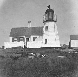
The Straitsmouth Island Light is a lighthouse located on Straitsmouth Island, in Rockport, Massachusetts. The original tower was built in 1835, and replaced by a second tower in 1896. It was automated in 1967, and is still in operation. The United States Coast Guard Light List description is "White cylindrical tower". The actual light is 46 feet above Mean High Water. The Light List name is "Straightsmouth Light", but the island is "Straitsmouth Island" on NOAA charts.
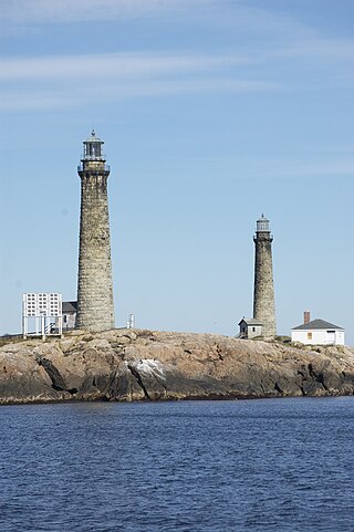
The Cape Ann Light Station on Thacher Island, off Cape Ann in Rockport, Massachusetts, is nationally significant as the last light station to be established under colonial rule and the first station in the United States to mark a navigational hazard rather than a harbor entrance. The current pair of lighthouses were built in 1861. They were both equipped with first order Fresnel lenses, which stood approximately 10 feet (3.0 m) high and weighed several tons (tonnes).

Fort Washington, also known as Fort Washington Park, is a historic site at 95 Waverly Street in Cambridge, Massachusetts. It was built by soldiers of the Continental Army under the orders of George Washington in November 1775. It is the oldest surviving fortification from the American Revolutionary War and the only surviving fortification from the Siege of Boston. Fort Washington was placed on the List of Registered Historic Places in Massachusetts on April 3, 1973.

The Tarpaulin Cove Light is a historic lighthouse on Naushon Island, one of the Elizabeth Islands of southern Massachusetts. It is located in the town of Gosnold, Massachusetts. Built on the site of a light station first established privately in the 18th century, the current tower dates from 1891. A keeper's house built at the same time has not survived. The light is 78 feet (24 m) above Mean High Water, and its white light is visible for 9 nautical miles.

Palmer Island Light Station is a historic lighthouse in New Bedford Harbor in New Bedford, Massachusetts, USA. The lighthouse was built in 1849 out of stone rubble. It was discontinued when the harbor's hurricane barrier was built in the early 1960s, as its location immediately north of the barrier was no longer an outlying danger and there are lights on either side of the barrier opening.

Bakers Island Light is a historic lighthouse on Bakers Island in Salem, Massachusetts. The station was originally established in 1791, with a daymark. This was replaced in 1798 by two lights atop a keeper's house, one at each end. After storm damage in 1815, an octagonal stone tower was constructed. The current round stone tower was added in 1820. The 1820 tower was taller, leading to the names "Ma" and "Pa". The two remained in service until 1926, when the older, shorter tower was removed.

The Newburyport Harbor Light, also known as Plum Island Light, built in 1788, is a historic lighthouse on Northern Boulevard in Newburyport, Massachusetts.

The Newburyport Harbor Rear Range Light is a historic lighthouse at 61½ Water St. near the Merrimack River in Newburyport, Massachusetts. It was built in 1873 as one of a pair of range lights for guiding ships up the river to the city's harbor.
The Ten Pound Island Light is a historic lighthouse in Gloucester Harbor in Gloucester, Massachusetts. It is located on Ten Pound Island, near the eastern end of the harbor. The tower, built in 1881, is a conical cast iron structure 30 feet (9.1 m) tall, replacing a stone tower first built on the site in 1821. The main body is painted white, and the top is painted black.

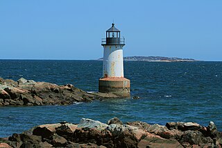
Fort Pickering Light, also known as Winter Island Light, is a lighthouse built in 1871 and discontinued by the Coast Guard in 1969. It was relit as a private aid to navigation by the City of Salem in 1983.
This is a list of the National Register of Historic Places listings in Springfield, Massachusetts.

Blackstone River Valley National Historical Park is a National Park Service unit in the states of Rhode Island and Massachusetts. The park was created for the purpose of preserving, protecting, and interpreting the industrial heritage of the Blackstone River Valley and the urban, rural, and agricultural landscape of that region. The Blackstone River Valley was the site of some of the earliest successful textile mills in the United States, and these mills contributed significantly to the earliest American Industrial Revolution. The subsequent construction of the Blackstone Canal, a few years after the successful completion of the Erie Canal, helped to sustain the region's industrial strength.


