
Roxbury is a neighborhood within the City of Boston, Massachusetts, United States.

Washington Street is a street originating in downtown Boston, Massachusetts, which extends southwestward to the Massachusetts–Rhode Island state line. The majority of its length outside of the city was built as the Norfolk and Bristol Turnpike in the early 19th century. It is the longest street in Boston and remains one of the longest streets in the Commonwealth of Massachusetts. Due to various municipal annexations with the city of Boston, the name Washington Street now exists 6 or more times within the jurisdiction(s) of the City of Boston.

Roxbury Crossing station is a rapid transit station in Boston, Massachusetts. It serves the MBTA Orange Line, and is located on Tremont Street in the Mission Hill neighborhood. The current station opened in 1987 as part of the renovation and relocation of the southern Orange Line. Like all stations on the Orange Line, Roxbury Crossing is accessible.

Nubian Square is the primary commercial center of the Roxbury neighborhood of Boston, Massachusetts, located at the intersection of Dudley Street and Washington Street. It has long been the center of African American culture in Boston, prior to which the area was primarily Jewish.

The 1767 Milestones are historic milestones located along the route of the Upper Boston Post Road between the cities of Boston and Springfield in Massachusetts. The 40 surviving milestones were added to the National Register of Historic Places in 1971. Massachusetts has a total of 129 surviving milestones including those along the upper Post Road. The stones are so named, despite having been placed in many different years, because of a 1767 directive of the Province of Massachusetts Bay that such stones be placed along major roadways. The state highway department was directed in 1960 to undertake their preservation. Many of them underwent a major restoration in 2018.

Eliot Burying Ground is a historic seventeenth-century graveyard at Eustis and Washington Streets in the Roxbury neighborhood of Boston, Massachusetts. It occupies a roughly triangular lot of 0.8 acres (0.32 ha).

The Dillaway School is an historic school at 16-20 Kenilworth Street in Boston, Massachusetts. The school was built in 1882 to a design by George Albert Clough, the city's first official architect, and is his only surviving school design in the city. The building was listed on the National Register of Historic Places in 1980, and included in the Roxbury Highlands Historic District in 1989. The building has been converted to residential use.

John Eliot Square District is a historic district located in the northern Roxbury neighborhood of Boston, Massachusetts. It is formed by the intersection of Dudley, Bartlett, Centre, Roxbury and Highland Streets. Named after local missionary to the Indians, John Eliot, the square was the site of the Roxbury town center after its founding in 1630. Roxbury was annexed to Boston in 1868, and John Eliot Square was added to the National Register of Historic Places in 1973. The square is the nucleus of Roxbury Heritage State Park, a history-themed heritage park.

The Lower Roxbury Historic District is a historic district encompassing an isolated pocket of 1890s mixed residential-commercial property in the lower Roxbury neighborhood of Boston, Massachusetts. Bounded by Tremont, Columbus, and Burke Streets and St. Cyprian's Place, the area contains a well-kept collection of architect designed buildings that survived late 20th-century urban redevelopment. The district was added to the National Register of Historic Places in 1994.

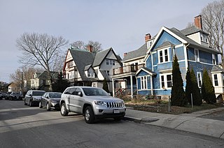
Mount Pleasant Historic District is a historic district encompassing a cluster of well-preserved 19th-century residential buildings on Forest Street and Mount Pleasant Avenue in the Roxbury neighborhood of Boston, Massachusetts. First developed in 1833, it was one Roxbury's first speculative residential subdivision developments. The district features Greek Revival, Italianate, and Romanesque architecture, and was added to the National Register of Historic Places in 1989.

The Memorial Square District encompasses the historic heart of the Memorial Square neighborhood of Springfield, Massachusetts. Arrayed around the Memorial Square at the junction of Main and Plainfield Streets are seven buildings of architectural and/or historic significance, including the Memorial Church, and the former Memorial Square Branch Library, now a Greek cultural center. It was added to the National Register of Historic Places in 1977.

The Front Street Historic District in Exeter, New Hampshire, encompasses a portion of the town's historic center. The district extends from Swasey Pavilion, at the junction of Front and Water streets, southwesterly along Front Street to Gale Park, about five blocks. Front Street is one of Exeter's oldest roads, and is lined with a series of 18th and 19th-century civic, religious, and residential structures, many of which are well preserved. The district was listed on the National Register of Historic Places (NRHP) in 1973.

Fort Hill is a 0.4 square mile neighborhood and historic district of Roxbury, in Boston, Massachusetts. The approximate boundaries of Fort Hill are Malcolm X Boulevard on the north, Washington Street on the southeast, and Columbus Avenue on the southwest.
The Cox Building is a historic building in Boston, Massachusetts, that stands at the intersection of Dudley and Bartlett Street in the neighborhood of Roxbury. It was constructed in 1870 to provide housing and commercial accommodation. The building is in two National Register districts, the Roxbury Highlands Historic District and the John Eliot Square District. In 1979, it was designated as a Boston Landmark by the Boston Landmarks Commission
The Crawford Street Historic District encompasses a collection of primarily residential apartment houses on Crawford Street between Elm Hill Avenue and Warren Street in the Roxbury neighborhood of Boston, Massachusetts, united States. The area was developed in the late 19th and early 20th centuries, and features well-preserved wood frame single and multi-family residences from that period, as well as the city's only extant Brutalist style branch library building. The district was listed on the National Register of Historic Places in 2020.

The Greenville Street Historic District is a historic district encompassing a primarily residential property in the Roxbury neighborhood of Boston, Massachusetts. Extending along Greenville Street, the district includes a diversity of architecture, and is prominent for significant urban renewal efforts conducted in the city in the 1960s and 1970s. The district was added to the National Register of Historic Places in 2021.
The Walnut Park Historic District is a historic district encompassing a cluster of multifamily brick buildings in the Roxbury neighborhood of Boston, Massachusetts. Roughly centered on the junction of Walnut Park and Waldren Road, the area was developed in the early 20th century during a major Jewish migration, and includes a fine sample of Colonial Revival architecture. The district was listed on the National Register of Historic Places in 2022.

Louis Weissbein (1831–1913) was a German-born American architect practicing in Boston, Massachusetts.
The Camden Street Development Historic District is a historic district encompassing a cluster of municipally owned residential apartment blocks in the Roxbury neighborhood of Boston, Massachusetts. It consists of three nearly identical buildings centered on Shawmut Avenue between Camden Street and Brannon Harris Way. The blocks were built in 1949 by the city to provide housing to low-income African-American veterans, and have had only minimal alteration since then. The district was listed on the National Register of Historic Places in 2022.
The Dudley Terrace–Dudley Street Historic District is a historic district encompassing a cluster of four multifamily brick buildings in the Dorchester neighborhood of Boston, Massachusetts. Centered on the junction of Dudley Street and Virginia Avenue, the area was developed in the mid-1890s, and includes good examples of Queen Anne and Renaissance Revival architecture. The district was listed on the National Register of Historic Places in 2022.


