Maidstone
| Name | Location | Type | Completed [note 1] | Date designated | Grid ref. [note 2] Geo-coordinates | Entry number [note 3] | Image |
|---|---|---|---|---|---|---|---|
| Church of St Margaret | Barming, Maidstone | Tower | Late 14th century or early 15th century | 23 May 1967 | TQ7200854225 51°15′40″N0°27′50″E / 51.261234°N 0.463895°E | 1060773 |  |
| Church of St James | Bicknor | Church | 1859-61 | 26 April 1968 | TQ8605658821 51°17′53″N0°40′03″E / 51.298108°N 0.667402°E | 1185510 |  |
| Court Lodge | Bicknor | House | Mid 17th century | 26 April 1968 | TQ8623858635 51°17′47″N0°40′12″E / 51.296378°N 0.669913°E | 1086227 |  Upload Photo |
| Church of St Nicholas | Boughton Malherbe | Parish Church | 13th century | 26 April 1968 | TQ8822849553 51°12′51″N0°41′37″E / 51.214151°N 0.693649°E | 1060861 |  |
| Hazel Hill Cottage | Sandway, Boughton Malherbe | Timber Framed House | c. 1400 | 2 February 1989 | TQ8948049212 51°12′38″N0°42′41″E / 51.210674°N 0.711373°E | 1252611 |  |
| Brishing Court | Boughton Monchelsea | Farmhouse | Early 15th century | 25 July 1952 | TQ7778551451 51°14′04″N0°32′43″E / 51.234545°N 0.54523°E | 1344355 | Upload Photo |
| Church of St Peter | Boughton Monchelsea | Church | possible late 11th century or 12th century | 25 March 1987 | TQ7711549895 51°13′15″N0°32′06″E / 51.220775°N 0.534875°E | 1060754 |  |
| Elm House and attached Railings | Boughton Monchelsea | House | Early 18th century | 23 May 1967 | TQ7742051149 51°13′55″N0°32′23″E / 51.231945°N 0.539858°E | 1068795 | Upload Photo |
| Harts House | Boughton Monchelsea | House | Later | 25 July 1952 | TQ7685151851 51°14′18″N0°31′55″E / 51.238428°N 0.532063°E | 1060784 | Upload Photo |
| Hertsfield Bridges | Boughton Monchelsea | Bridge | 14th century or 15th century | 25 July 1952 | TQ7825046762 51°11′32″N0°32′58″E / 51.192278°N 0.549555°E | 1060786 |  |
| Lychgate | Boughton Monchelsea | Lych Gate | 16th century or earlier | 25 July 1952 | TQ7709449920 51°13′16″N0°32′05″E / 51.221006°N 0.534587°E | 1068606 |  |
| Rabbit's Cross Farmhouse | Boughton Monchelsea | Farmhouse | 15th century | 23 May 1967 | TQ7851447381 51°11′52″N0°33′13″E / 51.197757°N 0.553637°E | 1060770 |  |
| Rock Cottage | Boughton Monchelsea | Continuous Jetty House | Late 16th century | 23 May 1967 | TQ7686651889 51°14′20″N0°31′56″E / 51.238765°N 0.532296°E | 1344353 | Upload Photo |
| Boxley Abbey House | Boxley Abbey, Boxley | Abbey | 1146 (founded) | 20 October 1952 | TQ7610358681 51°18′00″N0°31′29″E / 51.300014°N 0.52472°E | 1086228 |  |
| Parsonage Farm | Boxley | House | Early 14th century | 20 October 1952 | TQ7738858895 51°18′06″N0°32′36″E / 51.301537°N 0.54324°E | 1185727 | Upload Photo |
| St Andrew's Chapel | Boxley | Abbey | Late 15th century | 20 October 1952 | TQ7573658645 51°17′59″N0°31′10″E / 51.299804°N 0.519444°E | 1185580 | Upload Photo |
| Weavering Manor | Weavering, Boxley | Timber Framed House | Early 17th century | 13 July 1978 | TQ7838755792 51°16′24″N0°33′22″E / 51.273352°N 0.556006°E | 1185828 | Upload Photo |
| Church of St Margaret | Broomfield and Kingswood | Church | Late 11th century or 12th century | 26 April 1968 | TQ8400152495 51°14′31″N0°38′05″E / 51.241953°N 0.634706°E | 1060942 |  |
| Dunbury Farmhouse | Chart Sutton | Farmhouse | 14th century | 18 December 1985 | TQ7916246288 51°11′16″N0°33′44″E / 51.187736°N 0.562357°E | 1060947 | Upload Photo |
| Rugmer Hill Farmhouse | Collier Street | Farmhouse | late 14th century or early 15th century | 23 May 1967 | TQ7115048107 51°12′24″N0°26′55″E / 51.20653°N 0.44869°E | 1320370 | Upload Photo |
| Church of Saint Mary | East Farleigh | Tower | 13th century possibly earlier origins | 23 May 1967 | TQ7341453317 51°15′10″N0°29′01″E / 51.252652°N 0.483586°E | 1249534 |  |
| Luckhurst | East Sutton | Farmhouse | Late 15th century or early 16th century | 26 April 1968 | TQ8327947936 51°12′04″N0°37′19″E / 51.201235°N 0.622045°E | 1068646 | Upload Photo |
| Noahs Ark Farmhouse | East Sutton | Farmhouse | 14th century or early 15th century | 18 December 1985 | TQ8246746694 51°11′25″N0°36′35″E / 51.190338°N 0.609804°E | 1356139 | Upload Photo |
| Parsonage Farmhouse | East Sutton | Farmhouse | Early to mid 15th century | 26 April 1968 | TQ8331349287 51°12′48″N0°37′24″E / 51.213359°N 0.62322°E | 1356171 |  |
| The Blue House | East Sutton | House | Early 17th century | 26 April 1968 | TQ8317850251 51°13′19″N0°37′18″E / 51.222061°N 0.621782°E | 1344269 | Upload Photo |
| Walnut Tree Cottage | East Sutton | House | Late C16/early 17th century | 18 December 1985 | TQ8375149379 51°12′51″N0°37′46″E / 51.214045°N 0.629532°E | 1060930 | Upload Photo |
| Church of St Dunstan | Frinsted | Parish Church | 12th century | 26 April 1968 | TQ8917257403 51°17′04″N0°42′41″E / 51.284346°N 0.711294°E | 1336286 |  |
| Yokes Court | Frinsted | House | Early 17th century | 26 April 1968 | TQ8996056532 51°16′35″N0°43′20″E / 51.276261°N 0.722118°E | 1336287 |  |
| Gazebo cum Boathouse at TQ 872 529 | Harrietsham | Boat House | 1st half of 18th century | 26 April 1968 | TQ8711452953 51°14′42″N0°40′46″E / 51.245055°N 0.679491°E | 1185158 | Upload Photo |
| Greenway Forstal Farmhouse | Greenway Forstal, Harrietsham | Farmhouse | late 16th century or early 17th century | 26 April 1968 | TQ8513253415 51°14′59″N0°39′05″E / 51.249851°N 0.651366°E | 1299691 |  |
| Harrietsham Manor | Stede Hill, Harrietsham | House | Late 16th century | 14 December 1984 | TQ8785054210 51°15′22″N0°41′26″E / 51.256104°N 0.690683°E | 1086156 |  |
| Cloth Hall | Headcorn | Cloth Hall | Late C15-Early 16th century | 20 October 1986 | TQ8329544254 51°10′05″N0°37′13″E / 51.168156°N 0.620396°E | 1344312 |  |
| Headcorn Manor | Headcorn | House | C20 | 20 October 1952 | TQ8312944229 51°10′05″N0°37′05″E / 51.167984°N 0.618012°E | 1060835 | Upload Photo |
| Kelsham Farmhouse | Hawkenbury | Farmhouse | 17th century | 26 April 1968 | TQ8145044385 51°10′12″N0°35′39″E / 51.16992°N 0.594101°E | 1060838 | Upload Photo |
| Godfrey House | Hollingbourne | Timber Framed House | Late 16th century | 20 October 1952 | TQ8376254773 51°15′45″N0°37′57″E / 51.262492°N 0.632454°E | 1054873 |  |
| Malt House | Hollingbourne | House | 1986 | 20 October 1952 | TQ8446655336 51°16′02″N0°38′34″E / 51.267322°N 0.642823°E | 1344363 |  |
| Barn about 50 Metres South East of Buston Manor | Hunton | Barn | Late 14th century | 23 May 1967 | TQ7134650908 51°13′54″N0°27′10″E / 51.231635°N 0.45283°E | 1249915 |  |
| Buston Manor | Hunton | House | Late 17th century addition | 25 July 1952 | TQ7129050959 51°13′56″N0°27′07″E / 51.23211°N 0.452053°E | 1249912 |  |
| Granary About 40 Metres South East of Buston Manor | Hunton | Granary | Later 16th century or early 17th century | 23 May 1967 | TQ7133850921 51°13′54″N0°27′10″E / 51.231754°N 0.452722°E | 1249914 | Upload Photo |
| Stonewall Farmhouse Mounting Block and Garden Wall to East | Hunton | House | Late 16th century | 25 July 1952 | TQ7291448954 51°12′49″N0°28′28″E / 51.213609°N 0.474325°E | 1249763 |  |
| Church of St Mary | Langley | Church | 1853-1855 | 18 December 1985 | TQ8052251503 51°14′03″N0°35′04″E / 51.234153°N 0.584419°E | 1060898 |  |
| Langley Corner Farmhouse | Langley | Farmhouse | 15th century | 20 October 1952 | TQ8094251816 51°14′13″N0°35′26″E / 51.236832°N 0.590587°E | 1068799 |  |
| Battel Hall | Leeds | Hall House | second quarter 14th century | 20 October 1952 | TQ8276953308 51°14′59″N0°37′03″E / 51.249652°N 0.61749°E | 1336303 |  |
| Cordwainers | Leeds | Cross Passage House | 15th century | 26 April 1968 | TQ8099553622 51°15′11″N0°35′32″E / 51.253038°N 0.592257°E | 1185805 | Upload Photo |
| Manor House | Leeds | House | 19th century | 20 October 1952 | TQ8233053165 51°14′55″N0°36′40″E / 51.248508°N 0.611134°E | 1336304 |  |
| Vineys Cottages | Leeds | House | Mid 16th century | 20 October 1952 | TQ8195152621 51°14′37″N0°36′20″E / 51.243742°N 0.605433°E | 1336310 |  |
| Corner House, Lenham; Greengrocers, Rebecca's Antiques and Furnishings | Lenham | House | 1984 | 20 October 1952 | TQ8986752214 51°14′15″N0°43′07″E / 51.237509°N 0.718496°E | 1060957 |  |
| Forge House | Lenham | House | 1952 | 20 October 1952 | TQ8996152155 51°14′13″N0°43′11″E / 51.236948°N 0.71981°E | 1060992 | 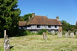 |
| Honeywood | Lenham | Jettied House | 1621 | 20 October 1952 | TQ8968952047 51°14′10″N0°42′57″E / 51.236068°N 0.715861°E | 1060976 |  |
| Lenham Court | Lenham | House | Late 16th century | 14 December 1984 | TQ8841851992 51°14′10″N0°41′52″E / 51.235995°N 0.697647°E | 1116246 |  |
| Royton Manor | Lenham Heath, Lenham | House | late 16th century or early 17th century | 26 April 1968 | TQ9038850340 51°13′14″N0°43′30″E / 51.220504°N 0.724956°E | 1060984 | Upload Photo |
| 14, 15 and 16, The Square | Lenham | House | Early 18th century | 20 October 1952 | TQ8992052178 51°14′14″N0°43′09″E / 51.237168°N 0.719235°E | 1060960 |  |
| Church of St Nicholas | Linton | Tower | 1860 | 23 May 1967 | TQ7545650144 51°13′25″N0°30′41″E / 51.223524°N 0.511264°E | 1250235 |  |
| Church of All Saints | Loose | Church | 13th century | 23 May 1967 | TQ7571752083 51°14′27″N0°30′57″E / 51.240862°N 0.515949°E | 1263275 |  |
| The Wool House and Garden Wall to North and East | Loose | House | Restored 1920s | 25 July 1952 | TQ7558552090 51°14′27″N0°30′51″E / 51.240966°N 0.514063°E | 1263154 |  |
| Chainhurst Farmhouse | Chainhurst | Farmhouse | Late 16th century | 23 May 1967 | TQ7309447947 51°12′16″N0°28′35″E / 51.204508°N 0.476414°E | 1060663 | Upload Photo |
| Great Cheveney House | Marden | Continuous Jetty House | Late 15th century or Early 16th century | 23 May 1967 | TQ7357842234 51°09′11″N0°28′50″E / 51.153038°N 0.480578°E | 1055805 | Upload Photo |
| White Lyon House | Marden | House | late 16th century or early 17th century | 23 May 1967 | TQ7459744593 51°10′26″N0°29′47″E / 51.17392°N 0.496278°E | 1345537 | Upload Photo |
| Gore Court | Otham | Kitchen | Late 16th century or early 17th century | 25 July 1952 | TQ7906253261 51°15′01″N0°33′52″E / 51.250405°N 0.564407°E | 1250699 | Upload Photo |
| Stoneacre and Path between Front Door and Road | Otham | Farmhouse | Formerly | 25 July 1952 | TQ7998053494 51°15′08″N0°34′40″E / 51.252209°N 0.577664°E | 1250995 |  |
| Church of St Lawrence | Otterden | Parish Church | 1753-59 | 26 April 1968 | TQ9473154184 51°15′13″N0°47′21″E / 51.253564°N 0.789157°E | 1060964 |  |
| Otterden Place, and Donkey Wheel attached | Otterden | Country House | Mid 16th century | 20 October 1952 | TQ9466854202 51°15′13″N0°47′18″E / 51.253747°N 0.788265°E | 1115729 | 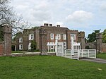 |
| Exhurst | Staplehurst | Farmhouse | late 14th century or early 15th century | 25 March 1987 | TQ7984642963 51°09′28″N0°34′14″E / 51.157653°N 0.570472°E | 1060748 | Upload Photo |
| Hush Heath Manor | Staplehurst | Continuous Jetty House | Early 17th century | 25 July 1952 | TQ7573040835 51°08′23″N0°30′38″E / 51.139814°N 0.510635°E | 1045800 |  |
| Little Harts Heath | Staplehurst | Wealden House | 15th century or early 16th century | 23 May 1967 | TQ7550041190 51°08′35″N0°30′27″E / 51.143074°N 0.507524°E | 1060730 |  |
| Loddenden Manor | Staplehurst | Continuous Jetty House | Mid-Late 16th century | 25 July 1952 | TQ7867643368 51°09′42″N0°33′14″E / 51.161657°N 0.553959°E | 1040054 | Upload Photo |
| Barham Court | Teston | House | 1932-1933 | 25 July 1952 | TQ7068453661 51°15′24″N0°26′41″E / 51.256565°N 0.444669°E | 1251014 | 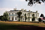 |
| Church of St Peter and St Paul | Teston | Tower | Pre 1736 | 23 May 1967 | TQ7055153506 51°15′19″N0°26′34″E / 51.255212°N 0.442691°E | 1251097 | 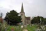 |
| Abbey Gate Farmhouse | Tovil | Larder | 15th century to 16th century | 30 July 1951 | TQ7526053653 51°15′18″N0°30′37″E / 51.255106°N 0.510176°E | 1086289 | Upload Photo |
| Bydews Place | Tovil | House | 17th century | 30 July 1951 | TQ7484154296 51°15′40″N0°30′16″E / 51.261011°N 0.504492°E | 1075786 | Upload Photo |
| Hayle Mill | Tovil, Maidstone | Mill House | c. 1800 | 2 August 1974 | TQ7559553870 51°15′25″N0°30′54″E / 51.256953°N 0.515079°E | 1267535 | 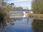 |
| Kingsnorth Manor Farmhouse | Ulcombe, Maidstone | Farmhouse | Late 16th century | 26 April 1968 | TQ8485147535 51°11′50″N0°38′40″E / 51.197127°N 0.644314°E | 1344290 |  |
| Benover House | Yalding | Farmhouse | early to mid 16th century | 23 May 1967 | TQ7046048245 51°12′29″N0°26′20″E / 51.207976°N 0.438887°E | 1060629 | Upload Photo |
| Burnt Oak | Yalding | House | C20 | 23 May 1967 | TQ7011348684 51°12′43″N0°26′03″E / 51.212024°N 0.434132°E | 1344428 | 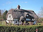 |
| Church House | Yalding | House | 1887 | 23 May 1967 | TQ6986050113 51°13′30″N0°25′52″E / 51.224937°N 0.43119°E | 1344038 | 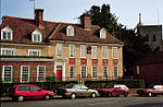 |
| Court Lodge and the Dairy House | Yalding | Farmhouse | Late 17th century | 25 July 1952 | TQ6985550207 51°13′33″N0°25′52″E / 51.225783°N 0.431163°E | 1069066 | 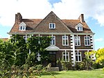 |
| Downs Farm House | Yalding | Farmhouse | 14th century or early 15th century | 23 May 1967 | TQ6991250359 51°13′38″N0°25′55″E / 51.227131°N 0.432051°E | 1348345 | Upload Photo |
| Nightingale Farmhouse | Yalding | Farmhouse | 14th century or early 15th century | 14 October 1987 | TQ6983149231 51°13′01″N0°25′49″E / 51.217022°N 0.430358°E | 1060627 | Upload Photo |
| Rose Cottages | Yalding | Farmhouse | 14th century or early 15th century | 23 May 1967 | TQ6997550252 51°13′34″N0°25′58″E / 51.226151°N 0.432901°E | 1348526 |  |
| The Normans | Benover, Yalding | Continuous Jetty House | late 16th century early 17th century | 13 May 1967 | TQ7004348738 51°12′45″N0°25′59″E / 51.21253°N 0.433157°E | 1115396 |  |
| Barming Place | Maidstone | House | Mid 18th century | 30 July 1951 | TQ7287954663 51°15′54″N0°28′36″E / 51.264906°N 0.476578°E | 1086294 | Upload Photo |
| Chillington House, Maidstone Museum & Art Gallery | Maidstone | House | 1561 | 30 July 1951 | TQ7589556005 51°16′34″N0°31′14″E / 51.276039°N 0.520423°E | 1222803 |  |
| Farm Cottages | Maidstone | Wealden House | 15th century | 30 July 1951 | TQ7791554183 51°15′33″N0°32′54″E / 51.259046°N 0.548447°E | 1266343 |  |
| Former Church of St Peter | Maidstone | Church | Converted to secular use | 30 July 1951 | TQ7559855633 51°16′22″N0°30′58″E / 51.272789°N 0.515986°E | 1086281 |  |
| Grove House | Maidstone | House | 18th century | 30 July 1951 | TQ7603056192 51°16′40″N0°31′21″E / 51.277677°N 0.522448°E | 1266232 | Upload Photo |
| Little Buckland Farm Cottage | Maidstone | End Jetty House | 14th century | 30 July 1951 | TQ7507456732 51°16′58″N0°30′32″E / 51.282823°N 0.50902°E | 1086397 | Upload Photo |
| Mote House | Mote Park, Maidstone | Country House | 1793 and 1801 | 30 July 1951 | TQ7809554991 51°15′58″N0°33′05″E / 51.266248°N 0.551426°E | 1086313 |  |
| Officers Quarters, Maidstone Former Cavalry Barracks | Maidstone | Officers Mess | c1797-1798 | 2 August 1974 | TQ7580856440 51°16′48″N0°31′10″E / 51.279974°N 0.519391°E | 1225271 | Upload Photo |
| Park House | Maidstone | House | 1792 | 2 August 1974 | TQ7587757468 51°17′21″N0°31′15″E / 51.289187°N 0.520885°E | 1086363 |  |
| Romney House | Maidstone | House | Early 18th century | 30 July 1951 | TQ7625555544 51°16′18″N0°31′31″E / 51.271787°N 0.525352°E | 1086274 |  |
| Stone House or the Judges Lodgings | Maidstone | House | Early 18th century | 30 July 1951 | TQ7621755517 51°16′18″N0°31′29″E / 51.271556°N 0.524794°E | 1224677 |  |
| The College | Maidstone | Teachers House | 14th century | 30 July 1951 | TQ7600955346 51°16′12″N0°31′18″E / 51.270084°N 0.521731°E | 1225072 |  |
| The Corpus Christi Hall | Maidstone | Guildhall | 1549-1871 | 30 July 1951 | TQ7583055804 51°16′27″N0°31′10″E / 51.274254°N 0.519393°E | 1086371 |  |
| The Dungeons at the Archbishop's Palace | Maidstone | Cell Block | 14th century medieval | 30 July 1951 | TQ7595255414 51°16′15″N0°31′15″E / 51.270713°N 0.520948°E | 1086309 | Upload Photo |
| The Old Farmhouse | Maidstone | Farmhouse | 15th century | 2 August 1974 | TQ7558057836 51°17′33″N0°31′01″E / 51.292584°N 0.516811°E | 1086362 | Upload Photo |
| The Town Hall | Maidstone | Cell Block | 1762-3 | 30 July 1951 | TQ7602755718 51°16′24″N0°31′20″E / 51.27342°N 0.522172°E | 1086305 |  |
| Turkey Court | Maidstone | Managers House | Mid 18th century | 30 July 1951 | TQ7719455535 51°16′17″N0°32′20″E / 51.271415°N 0.538794°E | 1238987 | Upload Photo |
| Willington Place | Maidstone | Jettied House | 15th century | 30 July 1951 | TQ7834054050 51°15′28″N0°33′16″E / 51.257718°N 0.554465°E | 1266284 |  |
| 11 Lower Stone Street | Maidstone | House | Early 18th century | 30 July 1951 | TQ7623155550 51°16′19″N0°31′30″E / 51.271848°N 0.525011°E | 1086332 | 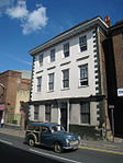 |
| 70 Lower Stone Street | Maidstone | Jettied House | 15th century | 30 July 1951 | TQ7624455399 51°16′14″N0°31′30″E / 51.270488°N 0.525123°E | 1336227 |  |
| 85 Bank Street | Maidstone | Shop | Early 19th century | 30 July 1951 | TQ7601755688 51°16′23″N0°31′19″E / 51.273154°N 0.522014°E | 1086357 | 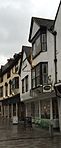 |
| 8 and 9 High Street | Maidstone | Wetherspoons | 1827 | 30 July 1951 | TQ7603255757 51°16′26″N0°31′20″E / 51.273769°N 0.522263°E | 1223181 | 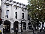 |
| 78 Bank Street | Maidstone | House | 18th century | 30 July 1951 | TQ7598855669 51°16′23″N0°31′18″E / 51.272992°N 0.521589°E | 1266847 | Upload Photo |
| The Queen's Own Royal West Kent Regiment Cenotaph | Brenchley Gardens, Maidstone | War memorial | 1921 | 2 August 1974 | TQ7588756128 51°16′38″N0°31′13″E / 51.277147°N 0.520369°E | 1086395 |  |
| Mansion Farmhouse | Ulcombe | House | 17th century | 26 April 1968 | TQ8585048954 51°12′34″N0°39′34″E / 51.209549°N 0.65933012°E | 1060889 | Upload Photo |