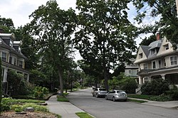
The Hastings Square Historic District is a historic district that encompasses Hastings Square, a small city park in Cambridge, Massachusetts, and the residential properties that abut it. The houses that line the streets across from the park are among the finest Queen Anne houses in the city. These properties were built between 1869 and 1892, and include two houses known to be designed by architects. The Queen Anne/Shingle style house at 302 Brookline Avenue was built in 1887 to a design by Rand & Taylor, and the 1892 Queen Anne house at 75 Henry Street was designed by Hartwell and Richardson.

The Salem–Auburn Streets Historic District is a residential historic district at Salem and Auburn Streets in Cambridge, Massachusetts. The district includes a collection of houses that is among the oldest in the Cambridgeport section of the city, and includes most of the houses on two blocks of these streets. The district was added to the National Register of Historic Places in 1982.

The Commonwealth Avenue Historic District of Newton, Massachusetts, encompasses roughly the eastern half of Commonwealth Avenue, extending from Waban Hill Road, near the city line with Boston, westward to Walnut Street. The roadway was laid out in 1894 and completed in 1895. Its design was influenced in part by the local residents, who were willing to give land for some of the route, and the design of Boston portions of the road, in which Frederick Law Olmsted was involved. Construction of the roadway was followed by the construction of fashionably large residences along its route, which took place mostly between the road's construction and about 1920. The district includes 188 residential properties, which are mainly built in the revival styles popular in the early 20th century. The district was added to the National Register of Historic Places in 1990.

The Old Chestnut Hill Historic District encompasses the historic residential heart of the Newton portion of Chestnut Hill, Massachusetts. When first listed on the National Register of Historic Places in 1986, the district extended along Hammond Street, between Beacon Street and the MBTA Green Line right-of-way, and along Chestnut Hill Road between Hammond and Essex, including properties along a few adjacent streets. The district was expanded in 1990 to include more of Chestnut Hill Road and Essex Road, Suffolk Road and the roads between it and Hammond, and a small section south of the Green Line including properties on Hammond Street, Longwood Road, and Middlesex Road. A further expansion in 1999 added a single property on Suffolk Road.
The Beacon Street Historic District is a historic district running most of the length of Beacon Street in Brookline, Massachusetts, roughly from Saint Mary's Road, near Kenmore Square, to Ayr Road near Cleveland Circle. It includes a small number of properties on adjacent streets, and was listed on the National Register of Historic Places in 1985.

The Beaconsfield Terraces Historic District is a residential historic district at 11–25, 33–43, and 44–55 Garrison Rd. and 316–326, 332–344, and 350–366 Tappan Street in Brookline, Massachusetts. It encompasses a collection of architecturally distinctive row houses that were built between 1889 and 1892 by a single developer, and represent a unique early success in condominium ownership. The district was listed on the National Register of Historic Places in 1985.

The Brookline Town Green Historic District encompasses the historic colonial heart of the town of Brookline, Massachusetts. Centered on a stretch of Walnut Street between Warren and Chestnut Streets, this area is where the town's first colonial meeting house and cemetery were laid out, and was its center of civic life until the early 19th century. The district was listed on the National Register of Historic Places in 1980.
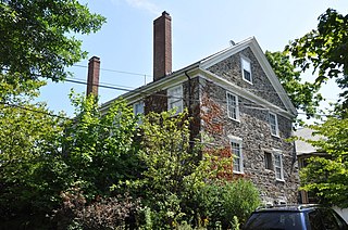
The Timothy Corey House No. 2 is a historic house at 786–788 Washington Street in Brookline, Massachusetts. Built in 1843, it is one of Brookline's few stone houses. It is a vernacular Greek Revival in style, and was home to members of one of the town's most prominent early families. It was listed on the National Register of Historic Places on October 17, 1985.

The Cottage Farm Historic District is a residential area in eastern Brookline, Massachusetts, United States, known for its association with industrialist Amos Adams Lawrence (1814–1886). Laid out in the 1850s and centered around the junction of Essex and Ivy Streets, it features high-quality housing on large lots, built between the 1850s and 1910s. The district was listed on the National Register of Historic Places in 1978.

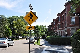
The Cypress–Emerson Historic District encompasses a residential area on the west side of Brookline Village in Brookline, Massachusetts, United States. Centered on Waverly and Cypress Streets, and including Emerson Park, this area was developed in the post-Civil War era, its growth matching that of the commercial areas of the village. The district was listed on the National Register of Historic Places in 1985.

The Robert S. Davis House is a historic house at 50 Stanton Road in Brookline, Massachusetts. Built about 1859 for the scion of a locally prominent family, it is one of the town's best-preserved examples of Italianate architecture. It was listed on the National Register of Historic Places in 1985.

The General Simon Elliot House is a historic house at 61 Heath Street in Brookline, Massachusetts. Built in 1824, it is one of the town's oldest examples of Greek Revival architecture, owned by several prominent residents. The house was listed on the National Register of Historic Places on October 17, 1985.

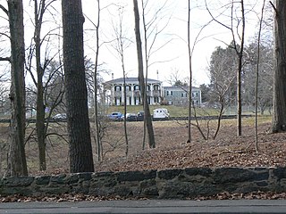
The Fisher Hill Historic District encompasses a residential area in central Brookline, Massachusetts. The area was subdivided and built out beginning in the 1880s, with landscaping design by Frederick Law Olmsted and John Charles Olmsted. The district is bounded on the west by Chestnut Hill Avenue, Baxter Road, and Channing Road, and on the south by Massachusetts Route 9. Its eastern boundary runs along Buckminster Street to Dean Road, joining the northern boundary of Clinton Road, running between Dean Road and Chestnut Hill Avenue. Prior to its development in the 1880s, Fisher Hill had a relatively small number of landowners. Some of them banded together, hiring the Olmsteds to design a subdivision plan for the entire district. Lots were sold to wealthy individuals, who built fashionable houses, often designed by architects. In 1914 a restrictive covenant was entered into by a significant number of property owners, restricting their properties to strictly single-family residential uses.
The Green Hill Historic District encompasses historical cross-section of residential housing in Brookline, Massachusetts, dating from the 18th century into the mid-20th century. The district includes properties on Warren, Cottage, and Fairmount Streets, and on Sargent Road, centered on the junction of Warren and Cottage Streets. The oldest houses date to the mid-18th century, and were originally modest Georgian or Federal structures. During the 19th century the area was populated by the summer estates of some of Boston's leading merchant and business families, including members of the Cabot and Perkins families. During the later 19th and early 20th centuries some of Brookline's largest and most architecturally interesting homes were built in this area.

12 Linden Street is a historic house located in Brookline, Massachusetts. It is a rare local example of Greek Revival styling, and one of a few houses to survive from the residential development of the Linden Street area in the 1840s.

The Thaddeus Jackson House is a historic house at 15 Alberta Road in Brookline, Massachusetts. Built in 1820, it is one of Brookline's older surviving houses, unusual because it was built in the Georgian style, then already out of fashion. The house was listed on the National Register of Historic Places on October 17, 1985.

The Strathmore Road Historic District is a residential historic district on Strathmore Road and Clinton Path in Brookline, Massachusetts. It consists of six brick apartment blocks, four of which lie on Strathmore Road, and two of which lie on Clinton Path. The two streets form a loop just south of the westernmost portion of Beacon Street, and abutting the MBTA Green Line yard at Cleveland Circle. The district is reflective of the area's growth as a commuter suburb following the development of the rail line along Beacon Street, and was listed on the National Register of Historic Places in 1985.

West Roxbury Parkway is a historic parkway running from Washington Street in Boston, Massachusetts, where the Enneking Parkway runs south, to Horace James Circle in Chestnut Hill, where it meets the Hammond Pond Parkway. The parkway serves as a connector between Stony Brook Reservation and Hammond Pond Reservation. West Roxbury Parkway was built between 1919 and 1929 and added to the National Register of Historic Places in 2006. The parkway is distinctive in the roadway system developed by the Metropolitan District Commission beginning around the turn of the 20th century in that it was built in collaboration with the City of Boston, and is maintained by the city.

The Chestnut Hill Historic District encompasses the historic portion of the village of Chestnut Hill that lies in Brookline, Massachusetts, with only slight overlap into adjacent Newton. The 70-acre (28 ha) district is bounded on the north by Middlesex Road, on the east by Reservoir Lane, on the south by Crafts Road and Massachusetts Route 9, and on the west by Dunster Road. A small portion of the district extends south of Route 9, including a few houses and the Baldwin School on Heath Street. The district was listed on the National Register of Historic Places on October 17, 1985.

Kilham & Hopkins was an architectural firm in Boston, Massachusetts formed in 1899 or 1900 by its founding members, Walter Harrington Kilham and James Cleveland Hopkins. The firm later became Kilham, Hopkins & Greeley after William Roger Greeley joined the firm in 1916, and Kilham Hopkins Greeley and Brodie after Walter S. (Steve) Brodie joined the firm in 1945.