Grappenhall

Last updated

Grappenhall
Grappenhall.jpg
Parr Arms and St Wilfrid's Church
Cheshire UK location map.svg
Red pog.svg
Grappenhall
Location within Cheshire
Population9,651 
OS grid reference SJ639863
Civil parish
Unitary authority
Ceremonial county
Region
Country England
Sovereign state United Kingdom
Post town WARRINGTON
Postcode district WA4
Dialling code 01925
Police Cheshire
Fire Cheshire
Ambulance North West
UK Parliament
List of places
UK
England
Cheshire
53°22′23″N2°32′35″W / 53.373°N 2.543°W / 53.373; -2.543

Grappenhall is a village within the civil parish of Grappenhall and Thelwall in the Borough of Warrington in Cheshire, England. The parish had a population of 9,377 at the 2001 census, [1] 9,687 at the 2011 census, [2] and 9,651 at the 2021 census. [3]

Contents

History

Grappenhall is first mentioned in the Domesday Book of 1086 with the name Gropenhale and with a valuation of five shillings.

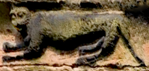
Sandstone carving of a 'Cheshire Cat', St Wilfrid's Church Sandstone carving of 'Cheshire Cat', St Wilfrid's Church, Grappenhall.jpg
Sandstone carving of a 'Cheshire Cat', St Wilfrid's Church

St Wilfrid's Church has a carving of a cat on the west face of the tower. This may have been Lewis Carroll's inspiration for the grinning Cheshire Cat in Alice's Adventures in Wonderland . [4] The church itself was first constructed in 1120, though was rebuilt 400 years later. The church was also, at a time, in the possession of the Boidelle (Boydell) family.[ citation needed ]

Along with the church, the centre of the village contains two pubs, the Parr Arms and the Ram's Head, and Grappenhall Hall Residential School (closed down) and St Wilfrid's Primary School. Bradshaw Community Primary School is located north of the village centre.

Leisure

Grappenhall Heys Walled Garden is near the village. [5] Grappenhall is home to the 25th Warrington East (St Wilfred's) Scout Troop. [6]

Sport

There is a cricket ground, which is the home of Grappenhall Cricket Club. [7] Australian cricketer Steve Smith was signed for the club for five weeks in 2007, when he was 17. [8]

Library

The Grappenhall Community library is a community-run library in the village. It was opened by the local authority in 1959 before being handed over to the Friends of Grappenhall Library after closure on 2 April 2011 [9] [10] due to local authority cuts. [11] The library is run by the Friends of the Grappenhall library who pay £10 a year to help with its upkeep. [12]

Parts of the Case-Book of Sherlock Holmes were filmed in the centre of Grappenhall. [13] The village name appears in the title of the song "Grappenhall Rag", by the Darwen singer-songwriter Bryn Haworth. [14]

See also

Related Research Articles

<span class="mw-page-title-main">Haworth</span> Village in West Yorkshire, England

Haworth is a village in the civil parish of Haworth and Stanbury, in the Bradford district, in the county of West Yorkshire, England, in the Pennines, 3 miles (5 km) south-west of Keighley, 10 miles (16 km) west of Bradford and 10 miles (16 km) east of Colne in Lancashire. The surrounding areas include Oakworth and Oxenhope. Nearby villages include Cross Roads, Stanbury and Lumbfoot.

<span class="mw-page-title-main">Woolston, Cheshire</span> Human settlement in England

Woolston is a settlement and civil parish in the Borough of Warrington in the county of Cheshire, England. Formerly a township called 'Woolston with Martinscroft' within the parish of Warrington, there are two main settlements: Woolston to the west and Martinscroft to the east. The parish is on the north bank of the River Mersey and takes in Paddington to the south-west. It is bounded by the River Mersey to the south, Bruche and Padgate to the west, Longbarn and Birchwood to the north and Rixton to the east.

<span class="mw-page-title-main">Warrington South (UK Parliament constituency)</span> Parliamentary constituency in the United Kingdom, 1983 onwards

Warrington South is a constituency represented in the House of Commons of the UK Parliament since 2019 by Andy Carter, a Conservative Party politician.

<span class="mw-page-title-main">Lymm</span> Village in Cheshire, England

Lymm is a village and civil parish in the Borough of Warrington, Cheshire, England, which incorporates the hamlets of Booths Hill, Broomedge, Church Green, Deansgreen, Heatley, Heatley Heath, Little Heatley, Oughtrington, Reddish, Rushgreen and Statham. At the 2021 United Kingdom census it had a population of 12,700.

Thelwall is a suburban village in the Borough of Warrington, Cheshire, England, close to the Lymm junction of the M6 motorway.

<span class="mw-page-title-main">Walking day</span>

A walking day is a type of church parade. Walking days are most common in North West England, where they are an annual event for many towns and villages. In some rural communities in the North West they are known as Field Days, Gala Days or Club Days.

Culcheth is a village in the Borough of Warrington, England, six miles (10 km) north-east of Warrington town centre; it is the principal settlement in Culcheth and Glazebury civil parish.

<span class="mw-page-title-main">Runcorn Rural District</span> Rural district in Cheshire, England

<span class="mw-page-title-main">Mobberley</span> Human settlement in England

Mobberley is a village in Cheshire, England, between Wilmslow and Knutsford, which in 2001 had a population of 2,546, increasing to 3,050 at the 2011 Census.

<span class="mw-page-title-main">Kingsley, Cheshire</span> Human settlement in England

Kingsley is a civil parish and a village in the unitary authority of Cheshire West and Chester and the ceremonial county of Cheshire, England. It is approximately 5 miles south east of the town of Frodsham.

<span class="mw-page-title-main">Grappenhall and Thelwall</span> Human settlement in England

Grappenhall and Thelwall is a civil parish within the Borough of Warrington and the ceremonial county of Cheshire in England. It has a population of 9,377.

<span class="mw-page-title-main">St Wilfrid's Church, Grappenhall</span> Church in Cheshire, England

St Wilfrid's Church is the parish church of Grappenhall, in the Borough of Warrington in Cheshire, England. It is designated by Historic England as a Grade I listed building. It is an active Anglican church in the diocese of Chester, the archdeaconry of Chester and the deanery of Great Budworth.

<span class="mw-page-title-main">All Saints Church, Thelwall</span> Church in Cheshire, England

All Saints Church is in the village of Thelwall, Cheshire, England. The church is recorded in the National Heritage List for England as a designated Grade II listed building. It is an active Anglican parish church in the diocese of Chester, the archdeaconry of Chester and the deanery of Great Budworth.

<i>Let the Days Go By</i> 1974 studio album by Bryn Haworth

Let the Days Go By is the first studio album by British singer-songwriter and guitarist Bryn Haworth, released in 1974 by Island Records.

<span class="mw-page-title-main">Borough of Warrington</span> Unitary authority area in Cheshire, England

The Borough of Warrington is a unitary authority area with borough status in the ceremonial county of Cheshire, North West England. The borough is centred around the town of Warrington, and extends out into outlying areas such as Lymm, Great Sankey, and Birchwood. The borough is geographically located to the north and northeast of the Cheshire West and Chester and Halton districts in Cheshire, the metropolitan borough of St Helens in Merseyside to the northwest and north and the metropolitan boroughs of Wigan and Trafford in Greater Manchester to the northeast, east, and southeast. Additionally, to the south-east, the borough borders Cheshire East. The borough is also located between the cities of Liverpool, Salford, Manchester, Chester and Preston. The district straddles the historic counties of Cheshire and Lancashire.

Grappenhall and Thelwall is a civil parish in the Borough of Warrington and the ceremonial county of Cheshire, England, and includes the villages of Grappenhall and Thelwall. The Bridgewater Canal and the A56 road pass through Grappenhall and to the south of Thelwall in an east–west direction, and the A50 road runs in a north–south direction between them. Within the parish are 30 buildings that are recorded in the National Heritage List for England as designated listed buildings. Of these, one is listed at Grade I, the highest of the three grades, and the other 28 at Grade II, the lowest grade. The Grade I listed building is a church dating back to the 12th century. The Grade II listed buildings comprise a variety of structures, including another church, houses, aqueducts, bridges, a public house, farm buildings, stocks, a sundial, a milepost, a mounting block, a war memorial, and a telephone kiosk.

<span class="mw-page-title-main">Warrington</span> Town in Cheshire, England

Warrington is an industrial town in the borough of the same name in Cheshire, England. The town sits on the banks of the River Mersey and until 1974, was part of Lancashire. It is 19 miles (31 km) east of Liverpool, and 18 miles (29 km) west of Manchester.

There are over 9,000 Grade I listed buildings and 20,000 Grade II* listed buildings in England. This page is a list of these buildings in the unitary authority of Warrington in Cheshire, including the town of Warrington and 18 other civil parishes.

<span class="mw-page-title-main">Grappenhall Heys Walled Garden</span>

Grappenhall Heys Walled Garden is a historic walled garden in Grappenhall, Warrington, Cheshire, England. The garden was built by Thomas Parr around 1830 as both a pleasure garden for relaxing strolls and as a kitchen garden to produce fruit, vegetables, and herbs. After a period of decline, the garden was restored first by English Partnerships and then by the local parish council in conjunction with the friends of the garden.

References

  1. 2001 Census: Grappenhall and Thelwall civil parish, Office for National Statistics, retrieved 10 June 2007
  2. UK Census (2011). "Local Area Report – Grappenhall and Thelwall Parish (E04000325)". Nomis. Office for National Statistics.
  3. https://www.citypopulation.de/en/uk/northwestengland/admin/warrington/E04000325__grappenhall_and_thelwall/
  4. History, St Wilfrid's Church, Grappenhall, retrieved 9 January 2021
  5. "Grappenhall Heys Walled Garden". Grappenhall and Thelwall Parish Council. 2018. Retrieved 13 December 2021.
  6. "25th Warrington East Scout Group » History". Grappenhallscouts.org.uk. 3 August 1914. Retrieved 6 August 2013.
  7. "Grappenhall Cricket Club". Grappers.com. Retrieved 6 August 2013.
  8. "Cheshire village cricket club recalls 'homesick' Steve Smith". BBC News. Retrieved 13 September 2019.
  9. "A brief history of Grappenhall Library". grappenhall.org.uk. Grappenhall Community Library. Retrieved 13 December 2016.
  10. "Grappenhall Community Library". Community Knowledge Hub. Retrieved 13 December 2016.
  11. "Grappenhall villagers win campaign to take ownership of former council library". warringtonguardian.co.uk. The Warrington Guardian. Retrieved 13 December 2016.
  12. "Community libraries: 10 case studies" (PDF). locality.org.uk. Retrieved 13 December 2016.
  13. "Filming Location Matching "Grappenhall, Warrington, Cheshire, England, UK" (Sorted by Popularity Ascending)". IMDb. Retrieved 13 December 2021.
  14. "Bryn Haworth Grappenhall Rag". YouTube. 20 November 2012. Archived from the original on 22 December 2021. Retrieved 6 August 2013.