
Carshalton is a town, with a historic village centre, in south London, England, within the London Borough of Sutton. It is situated 9.5 miles (15.3 km) south-southwest of Charing Cross, in the valley of the River Wandle, one of the sources of which is Carshalton Ponds in the middle of the village. Prior to the creation of Greater London in 1965, Carshalton was in the administrative county of Surrey.

Aigburth is a suburb of Liverpool, England. Located to the south of the city, it is bordered by Dingle, Garston, Mossley Hill, and Toxteth.

Toxteth is an inner-city area of Liverpool in the historic county of Lancashire and the ceremonial county of Merseyside.

Speke is a suburb of Liverpool. It is 7.7 miles (12.4 km) southeast of the city centre. Located near the widest part of the River Mersey, it is bordered by the suburbs of Garston and Hunts Cross, and nearby to Halewood, Hale Village, and Widnes. The rural area of Oglet borders its south.

Garston is a district of Liverpool, England. Historically in Lancashire, it is bordered by the suburbs of Grassendale, Allerton, and Speke. It lies on the Eastern banks of the River Mersey.

Wallasey is a town in the Metropolitan Borough of Wirral, Merseyside, England. Within the boundaries of the historic county of Cheshire, it is at the mouth of the River Mersey, on the north-eastern corner of the Wirral Peninsula. At the 2011 Census, the population was 60,284.

Northenden is a suburb of Manchester, Greater Manchester, England, with a population of 14,771 at the 2011 census. It lies on the south side of the River Mersey, 4.2 miles (6.8 km) west of Stockport and 5.2 miles (8.4 km) south of Manchester city centre, bounded by Didsbury to the north, Gatley to the east, Sale to the west and Wythenshawe to the south.

The Garston and Liverpool Railway line ran from the St Helens and Runcorn Gap Railway line at Garston Docks to Brunswick railway station, later to central Liverpool. The company was formed on 17 May 1861 and the line opened on 1 June 1864.

The architecture of Liverpool is rooted in the city's development into a major port of the British Empire. It encompasses a variety of architectural styles of the past 300 years, while next to nothing remains of its medieval structures which would have dated back as far as the 13th century. Erected 1716–18, Bluecoat Chambers is supposed to be the oldest surviving building in central Liverpool.
W. & G. Audsley was the architectural practice founded in Liverpool, UK, by Scottish Brothers William James Audsley and George Ashdown Audsley.
Liverpool is a city and port in Merseyside, England, which contains many listed buildings. A listed building is a structure designated by English Heritage of being of architectural and/or of historical importance and, as such, is included in the National Heritage List for England. There are three grades of listing, according to the degree of importance of the structure. Grade I includes those buildings that are of "exceptional interest, sometimes considered to be internationally important"; the buildings in Grade II* are "particularly important buildings of more than special interest"; and those in Grade II are "nationally important and of special interest". Very few buildings are included in Grade I — only 2.5% of the total. Grade II* buildings represent 5.5% of the total, while the great majority, 92%, are included in Grade II.

Cressington railway station serves the Grassendale district of Liverpool, England. It is situated on the Southport-Hunts Cross route of the Northern Line of the Merseyrail suburban system. The station takes its name from the Cressington Park area inside of Cressington.
The following is a timeline of the history of the city of Liverpool, England.
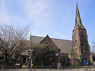
St Mary's Church is in St. Mary's Road, Grassendale, a district of Liverpool, Merseyside, England. It is an active Anglican parish church in the deanery of Liverpool South Childwall, the archdeaconry of Liverpool, and the diocese of Liverpool. The church is recorded in the National Heritage List for England as a designated Grade II listed building.
Arthur Hill Holme (1814–1857) was a Liverpool architect and brother of builder Samuel Holme, who served as Mayor of Liverpool in 1852–1853.


.jpg#/media/File:Salisbury_Road,_Grassendale_(1).jpg)