
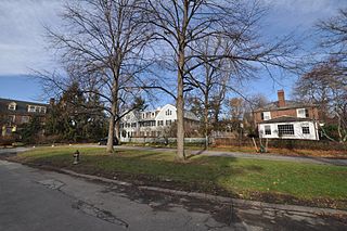
The West Newton Hill NR Historic District is a residential National Register historic district in the village of West Newton, in the city of Newton, Massachusetts in the United States. It is composed of a cohesive collection of spacious houses built in the second half of the 19th century, representing the development of the West Newton area as a fashionable railroad suburb. The district was listed on the National Register of Historic Places in 1986.
The Gray Gardens East and West Historic District is a historic district encompassing an early 20th century residential subdivision in Cambridge, Massachusetts. The subdivision includes all of the properties on Gray Gardens, as well as the adjacent 91 Garden Street and 60 Raymond Street. The subdivision was created by a group of interested individuals who sought to control development of one of the last estates in the area to be developed. They subdivided the land themselves, and imposed architectural restrictions on what could be built. Most of the houses were built between 1922 and 1930 and are neo-Georgian in style; the principal exception is the Hall Tavern, a Federal style tavern built in the 1790s and moved to the area from Duxbury, Massachusetts. The other unusual house is at 16 Gray Gardens East; it is a Tudor Revival house.

The Kensington Park Historic District of Arlington, Massachusetts encompasses a turn of the 20th century planned residential subdivision in the hills above the town center, representing an early phase in the town's transition from a rural to suburban setting. The district consists of most of the houses on Brantwood and Kensington Roads, which wind around a rocky hillside overlooking Pleasant Street and Spy Pond, just west of the center. A number of the houses are the work of architect C. Herbert McClare, who also lived in the area, and was one of the development's proponents. The district was listed on the National Register of Historic Places in 1985.

The Everett Avenue–Sheffield Road Historic District is a historic district encompassing one of the finest residential districts from the turn of the 20th century in Winchester, Massachusetts. The district is roughly triangular in shape, bounded in the north by Bacon Street, on the west by Church Street, Sheffield West, and Sheffield Road, and on the south and heast by the Upper Mystic Lake and Mystic Valley Parkway. It is characterized by winding roads, with relatively large houses on well-proportioned lots. Most of the houses were built between 1890 and 1916, and all exhibit some architectural sophistication. A significant number of properties were designed by either F. Patterson Smith or Dexter Blaikie, two local architects. The district was listed on the National Register of Historic Places in 1989.

The Firth–Glengarry Historic District encompasses a residential area of Winchester, Massachusetts consisting of well-preserved high quality houses built mainly between 1880 and 1900. The district lies between Wildwood Street and Wedge Pond, and includes properties on Pine Street, Glengarry Road, Grassmere Avenue, Dix Street, and Wildwood Street; houses on Curtis Street and Curtis Circle, are excluded from the district. Much of the area was laid out by developer William Firth, and many of its houses were designed by Boston architect Robert Coit. The 13.44-acre (5.44 ha) district was listed on the National Register of Historic Places in 1989.

The Wedgemere Historic District encompasses the largest single 19th-century residential development of Winchester, Massachusetts. It is one of the town's largest surviving 19th-century residential subdivisions, with a concentration of high-quality residences built between about 1890 and 1920. The district was listed on the National Register of Historic Places in 1989.

The Brigham House is a historic house at 235 Main Street in Waltham, Massachusetts. Built about 1893, it is an architecturally distinctive hybrid of Queen Anne, Shingle, and Colonial Revival styling. It was listed on the National Register of Historic Places in 1989.

Hammond Heights is an historic neighborhood subdivision on the west side of Worcester, Massachusetts. It includes properties along Germain, Haviland, Highland, and Westland Streets and Institute Road, most of which were built between 1890 and 1918, and is a good example of a turn-of-the-century residential subdivision, with a diversity of period architectural styles. The district was listed on the National Register of Historic Places in 1980.

Montvale is a residential historic district in northwestern Worcester, Massachusetts. It is a portion of a subdivision laid out in 1897 on the estate of Jared Whitman, Jr., whose property contained a single house, now 246 Salisbury Street. The central portion of this house was built in 1851 in a conventional Greek Revival style, and was expanded with the addition of side wings by the developers of the 1897 subdivision, H. Ballard and M. O. Wheelock.

The Brae Burn Road Historic District is a residential historic district on Brae Burn and Windermere Roads in Newton, Massachusetts. It encompasses as modest residential subdivision that was laid out in the then-rural area of Auburndale in 1911. Many of its houses were designed by the regionally notable firm of Gay & Proctor, and represent a well-preserved collection of modestly scaled Craftsman and Colonial Revival style houses. The district includes 26 houses. The district was listed on the National Register of Historic Places in 1990.

The Day Estate Historic District encompasses part of a subdivided estate at the corner of Commonwealth Avenue and Dartmouth Street in Newton, Massachusetts, United States. The district is bounded by Commonwealth, Dartmouth, Chestnut, and Prince Streets, and includes six houses located on Commonwealth and Dartmouth. It was originally owned by Henry Day, a banker, who in 1896 built the house at 321 Chestnut Street. The block was subdivided during a building boom in the 1920s, and the new houses were built between 1928 and 1930. All six houses are high quality Tudor Revival structures, five of them designed by William J. Freethey. Day's estate house is now home to the All Newton Music School, and the rest of the northeastern portion of the estate has more modern construction. The district was listed on the National Register of Historic Places in 1990.
The Farlow Hill Historic District is a residential historic district in the Newton Corner area of Newton, Massachusetts, United States. It includes houses on Shornecliffe Road, Beechcroft Road, Farlow Road, Huntington Road, and a few properties on immediately adjacent streets. Most of the houses in the district were built between 1899 and the late 1920s and are either Craftsman or Colonial Revival in their style. The area was created by the subdivision of the estate of John Farlow, and includes 37 large and well-appointed houses, generally architect-designed, on ample lots. The district was listed on the National Register of Historic Places in 1990.

The Hyde Avenue Historic District is a residential historic district encompassing the stylistic range of houses being built in the Newton Corner area of Newton, Massachusetts in the 1880s. It includes the five houses at 36, 42, 52, 59, and 62 Hyde Avenue, The district was added to the National Register of Historic Places in 1986.

The Monadnock Road Historic District is a residential historic district encompassing a cohesive subdivision of a former estate in the 1920s in the Chestnut Hill section of Newton, Massachusetts. The development was typical of Newton's explosive residential growth at that time, and includes primarily Tudor Revival houses. The district was listed on the National Register of Historic Places in 1990.
The Morton Road Historic District encompasses an example of a small residential subdivision in Newton, Massachusetts that was attractively designed in 1915. The architect-designed subdivision filled in an area otherwise surrounded by roads that had been developed earlier, and was built out between 1915 and 1928, with a fairly uniform use of Craftsman and Tudor Revival styling. The district was listed on the National Register of Historic Places in 1990.

The Old Chestnut Hill Historic District encompasses the historic residential heart of the Newton portion of Chestnut Hill, Massachusetts. When first listed on the National Register of Historic Places in 1986, the district extended along Hammond Street, between Beacon Street and the MBTA Green Line right-of-way, and along Chestnut Hill Road between Hammond and Essex, including properties along a few adjacent streets. The district was expanded in 1990 to include more of Chestnut Hill Road and Essex Road, Suffolk Road and the roads between it and Hammond, and a small section south of the Green Line including properties on Hammond Street, Longwood Road, and Middlesex Road. A further expansion in 1999 added a single property on Suffolk Road.

The Pine Ridge Road–Plainfield Street Historic District encompasses a residential subdivision in the Waban section of Newton, Massachusetts. It includes 44 properties on Pine Ridge Road and Plainfield Street between Chestnut Street and Upland Road, and includes a few properties on the latter two streets. The area was laid out for development in the 1880s after the arrival of suburban rail service, and was built out by the 1930s. The district was listed on the National Register of Historic Places in 1990.

The Windsor Road Historic District is a residential historic district just north of the village of Waban in Newton, Massachusetts.It includes 48 houses on Windsor, Kent and Hereford Roads, a cul-de-sac subdivision adjacent to the village center and the Brae Burn Country Club, which was mostly developed between 1888 and 1920. It was added to the National Register of Historic Places in 1990.

The Sumner and Gibbs Streets Historic District is a residential historic district encompassing a cohesive collection of houses representing styles common in the Newton Centre area of Newton, Massachusetts during its first period of growth. It includes houses along Sumner Street, between Cotswold Terrace and Willow Street, and the adjacent house at 184 Gibbs Street. The houses were built between 1865 and 1899, and are predominantly in the Queen Anne and Colonial Revival styles. The district was listed on the National Register of Historic Places in 1986.

The Chestnut Hill Historic District encompasses the historic portion of the village of Chestnut Hill that lies in Brookline, Massachusetts, with only slight overlap into adjacent Newton. The 70-acre (28 ha) district is bounded on the north by Middlesex Road, on the east by Reservoir Lane, on the south by Crafts Road and Massachusetts Route 9, and on the west by Dunster Road. A small portion of the district extends south of Route 9, including a few houses and the Baldwin School on Heath Street. The district was listed on the National Register of Historic Places on October 17, 1985.


