
Chestnut Hill is a wealthy New England village located six miles (10 km) west of downtown Boston, Massachusetts, United States. It is best known for being home to Boston College and a section of the Boston Marathon route. Like all Massachusetts villages, Chestnut Hill is not an incorporated municipal entity. It is located partially in Brookline in Norfolk County; partially in the city of Boston in Suffolk County, and partially in the city of Newton in Middlesex County. Chestnut Hill's borders are defined by the 02467 ZIP Code. The name refers to several small hills that overlook the 135-acre Chestnut Hill Reservoir rather than one particular hill.

Ashland Park is a historic early 20th century neighborhood in Lexington, Kentucky, United States. It was named after Ashland, the estate of Kentucky statesman Henry Clay which is located in the eastern portion of the neighborhood. The 600-acre (2.4 km2) development was designed by the famous landscape architecture firm the Olmsted Brothers of Massachusetts. The neighborhood belongs to the National Register of Historic Places.

The West Newton Hill NR Historic District is a residential National Register historic district in the village of West Newton, in the city of Newton, Massachusetts in the United States. It is composed of a cohesive collection of spacious houses built in the second half of the 19th century, representing the development of the West Newton area as a fashionable railroad suburb. The district was listed on the National Register of Historic Places in 1986.

26 Center Avenue in Reading, Massachusetts is an architecturally eclectic cottage, with a mix of Greek Revival, Gothic Revival, and Italianate features. Built c. 1854–1875, it is a rare surviving remnant of a residential subdivision once dubbed "Mudville" for the condition of its unpaved roads. The house was listed on the National Register of Historic Places in 1984.

The Orvis Road Historic District is a residential historic district in eastern Arlington, Massachusetts. Built as a planned development between 1918 and 1930, Orvis Road contains a well-preserved collection of single and double-family houses of the period, as well its distinctive landscaping, which includes a grassy median not found in Arlington's other planned subdivisions. The district was added to the National Register of Historic Places in 1985.

The Everett Avenue–Sheffield Road Historic District is a historic district encompassing one of the finest residential districts from the turn of the 20th century in Winchester, Massachusetts. The district is roughly triangular in shape, bounded in the north by Bacon Street, on the west by Church Street, Sheffield West, and Sheffield Road, and on the south and heast by the Upper Mystic Lake and Mystic Valley Parkway. It is characterized by winding roads, with relatively large houses on well-proportioned lots. Most of the houses were built between 1890 and 1916, and all exhibit some architectural sophistication. A significant number of properties were designed by either F. Patterson Smith or Dexter Blaikie, two local architects. The district was listed on the National Register of Historic Places in 1989.

The Wedgemere Historic District encompasses the largest single 19th-century residential development of Winchester, Massachusetts. It is one of the town's largest surviving 19th-century residential subdivisions, with a concentration of high-quality residences built between about 1890 and 1920. The district was listed on the National Register of Historic Places in 1989.

The Nobility Hill Historic District is a residential historic district roughly bounded by Chestnut and Maple Streets and Cedar Avenue in Stoneham, Massachusetts. The district includes a number of high quality houses representing a cross section of fashionable housing built between 1860 and 1920. It was added to the National Register of Historic Places in 1990.

Montvale is a residential historic district in northwestern Worcester, Massachusetts. It is a portion of a subdivision laid out in 1897 on the estate of Jared Whitman, Jr., whose property contained a single house, now 246 Salisbury Street. The central portion of this house was built in 1851 in a conventional Greek Revival style, and was expanded with the addition of side wings by the developers of the 1897 subdivision, H. Ballard and M. O. Wheelock.

The Commonwealth Avenue Historic District of Newton, Massachusetts, encompasses roughly the eastern half of Commonwealth Avenue, extending from Waban Hill Road, near the city line with Boston, westward to Walnut Street. The roadway was laid out in 1894 and completed in 1895. Its design was influenced in part by the local residents, who were willing to give land for some of the route, and the design of Boston portions of the road, in which Frederick Law Olmsted was involved. Construction of the roadway was followed by the construction of fashionably large residences along its route, which took place mostly between the road's construction and about 1920. The district includes 188 residential properties, which are mainly built in the revival styles popular in the early 20th century. The district was added to the National Register of Historic Places in 1990.
The Crystal Lake and Pleasant Street Historic District encompasses a streetcar suburban residential subdivision developed between 1860 and 1895 in Newton, Massachusetts. The district roughly bounded by the Sudbury Aqueduct, Pleasant Street, Lake Avenue, Webster Court, and Crystal Street. The subdivision was laid out in the 1850s after the Boston and Charles Railroad line was extended through Newton from Brookline. The district was listed on the National Register of Historic Places in 1986.

The Day Estate Historic District encompasses part of a subdivided estate at the corner of Commonwealth Avenue and Dartmouth Street in Newton, Massachusetts, United States. The district is bounded by Commonwealth, Dartmouth, Chestnut, and Prince Streets, and includes six houses located on Commonwealth and Dartmouth. It was originally owned by Henry Day, a banker, who in 1896 built the house at 321 Chestnut Street. The block was subdivided during a building boom in the 1920s, and the new houses were built between 1928 and 1930. All six houses are high quality Tudor Revival structures, five of them designed by William J. Freethey. Day's estate house is now home to the All Newton Music School, and the rest of the northeastern portion of the estate has more modern construction. The district was listed on the National Register of Historic Places in 1990.
The Farlow Hill Historic District is a residential historic district in the Newton Corner area of Newton, Massachusetts, United States. It includes houses on Shornecliffe Road, Beechcroft Road, Farlow Road, Huntington Road, and a few properties on immediately adjacent streets. Most of the houses in the district were built between 1899 and the late 1920s and are either Craftsman or Colonial Revival in their style. The area was created by the subdivision of the estate of John Farlow, and includes 37 large and well-appointed houses, generally architect-designed, on ample lots. The district was listed on the National Register of Historic Places in 1990.

The Gray Cliff Historic District is a residential historic district encompassing a cluster of exceptionally high quality houses built in Newton, Massachusetts, between about 1890 and 1940. When first listed on the National Register of Historic Places in 1986, it included only the eight houses at 35, 39, 43, 53, 54 ,, 64, 65, and 70 Gray Cliff Road, which were predominantly Shingle style house built before the turn of the 20th century. The district was expanded in 1990 to include an adjacent area known as The Ledges, where the houses were built between 1900 and 1940, and are mainly Colonial Revival and Tudor Revival in their styling.
The Morton Road Historic District encompasses an example of a small residential subdivision in Newton, Massachusetts that was attractively designed in 1915. The architect-designed subdivision filled in an area otherwise surrounded by roads that had been developed earlier, and was built out between 1915 and 1928, with a fairly uniform use of Craftsman and Tudor Revival styling. The district was listed on the National Register of Historic Places in 1990.

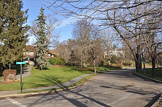
The Old Chestnut Hill Historic District encompasses the historic residential heart of the Newton portion of Chestnut Hill, Massachusetts. When first listed on the National Register of Historic Places in 1986, the district extended along Hammond Street, between Beacon Street and the MBTA Green Line right-of-way, and along Chestnut Hill Road between Hammond and Essex, including properties along a few adjacent streets. The district was expanded in 1990 to include more of Chestnut Hill Road and Essex Road, Suffolk Road and the roads between it and Hammond, and a small section south of the Green Line including properties on Hammond Street, Longwood Road, and Middlesex Road. A further expansion in 1999 added a single property on Suffolk Road.

The Pine Ridge Road–Plainfield Street Historic District encompasses a residential subdivision in the Waban section of Newton, Massachusetts. It includes 44 properties on Pine Ridge Road and Plainfield Street between Chestnut Street and Upland Road, and includes a few properties on the latter two streets. The area was laid out for development in the 1880s after the arrival of suburban rail service, and was built out by the 1930s. The district was listed on the National Register of Historic Places in 1990.

The Fisher Hill Historic District encompasses a residential area in central Brookline, Massachusetts. The area was subdivided and built out beginning in the 1880s, with landscaping design by Frederick Law Olmsted and John Charles Olmsted. The district is bounded on the west by Chestnut Hill Avenue, Baxter Road, and Channing Road, and on the south by Massachusetts Route 9. Its eastern boundary runs along Buckminster Street to Dean Road, joining the northern boundary of Clinton Road, running between Dean Road and Chestnut Hill Avenue. Prior to its development in the 1880s, Fisher Hill had a relatively small number of landowners. Some of them banded together, hiring the Olmsteds to design a subdivision plan for the entire district. Lots were sold to wealthy individuals, who built fashionable houses, often designed by architects. In 1914 a restrictive covenant was entered into by a significant number of property owners, restricting their properties to strictly single-family residential uses.

Midtown has an area of six square miles in Columbus, Georgia. It possesses residential neighbourhoods, eleven public schools, the Columbus Museum, the Columbus Public Library, the Muscogee County Public Education Center, the Columbus Aquatic Center and the international headquarters for Aflac. The population of Midtown is 22,000 residents living in 8500 households and is 10 kilometres north of Fort Benning on I-185.

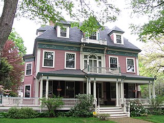
The Chestnut Hill Historic District encompasses the historic portion of the village of Chestnut Hill that lies in Brookline, Massachusetts, with only slight overlap into adjacent Newton. The 70-acre (28 ha) district is bounded on the north by Middlesex Road, on the east by Reservoir Lane, on the south by Crafts Road and Massachusetts Route 9, and on the west by Dunster Road. A small portion of the district extends south of Route 9, including a few houses and the Baldwin School on Heath Street. The district was listed on the National Register of Historic Places on October 17, 1985.


