Green Harbor-Cedar Crest, Massachusetts

Last updated
Green Harbor-Cedar Crest
Bay Avenue, Green Harbor MA.jpg
Bay Avenue in Green Harbor
USA Massachusetts location map.svg
Red pog.svg
Usa edcp location map.svg
Red pog.svg
Coordinates: 42°4′29″N70°39′30″W / 42.07472°N 70.65833°W / 42.07472; -70.65833
Country United States
State Massachusetts
County Plymouth
Towns Duxbury
Marshfield
Area
  Total1.9 sq mi (5.0 km2)
  Land1.8 sq mi (4.6 km2)
  Water0.2 sq mi (0.4 km2)
Population
 (2010)
  Total2,609
  Density1,400/sq mi (520/km2)
Time zone UTC-5 (Eastern (EST))
  Summer (DST) UTC-4 (EDT)
ZIP code
[1]
Area code 339 / 781
FIPS code 25-27147

Green Harbor-Cedar Crest was a census-designated place (CDP) in the towns of Duxbury and Marshfield in Plymouth County, United States. It included the village of Green Harbor, on the shore of Massachusetts Bay, and the community of Cedar Crest, occupying a hill on the north side of Careswell Street. The population of the CDP was 2,609 at the 2010 census. [2] Prior to the 2020 census the area was split into two CDPs, Green Harbor and Cedar Crest.

Contents

Geography

The Green Harbor-Cedar Crest CDP was located at 42°4′25″N70°39′22″W / 42.07361°N 70.65611°W / 42.07361; -70.65611 (42.073624, -70.656161). [3]

According to the United States Census Bureau, the CDP had a total area of 5.0 km2 (1.9 mi2), of which 4.6 km2 (1.8 mi2) was land and 0.4 km2 (0.2 mi2) (8.29%) was water.

Demographics

As of the census [4] of 2000, there were 2,397 people, 869 households, and 662 families residing in the CDP. The population density was 519.9/km2 (1,349.3/mi2). There were 1,117 housing units at an average density of 242.3/km2 (628.8/mi2). The racial makeup of the CDP was 98.50% White, 0.38% African American, 0.08% Native American, 0.21% Asian, 0.04% Pacific Islander, 0.54% from other races, and 0.25% from two or more races. Hispanic or Latino of any race were 1.21% of the population.

There were 869 households, out of which 37.5% had children under the age of 18 living with them, 62.0% were married couples living together, 10.5% had a female householder with no husband present, and 23.8% were non-families. 18.4% of all households were made up of individuals, and 5.6% had someone living alone who was 65 years of age or older. The average household size was 2.76 and the average family size was 3.18.

In the CDP, the population was spread out, with 27.0% under the age of 18, 5.7% from 18 to 24, 31.6% from 25 to 44, 26.5% from 45 to 64, and 9.2% who were 65 years of age or older. The median age was 38 years. For every 100 females, there were 92.8 males. For every 100 females age 18 and over, there were 89.4 males.

The median income for a household in the CDP was $74,375, and the median income for a family was $81,275. Males had a median income of $43,750 versus $38,913 for females. The per capita income for the CDP was $29,200. About 1.8% of families and 2.6% of the population were below the poverty line, including 2.4% of those under age 18 and none of those age 65 or over.

Related Research Articles

<span class="mw-page-title-main">Taylorsville, California</span> Census-designated place in California, United States

Taylorsville is a census-designated place (CDP) in Plumas County, California, United States. The population was 150 at the 2010 census, down from 154 at the 2000 census. The annual Stone Ranch Reunion is held in Taylorsville.

<span class="mw-page-title-main">Crest, California</span> Census-designated place in California, United States

Crest is an unincorporated community in the East County region of San Diego County, California. The Crest census-designated place (CDP) had a population of 2,828 at the 2020 census, down from 2,593 at the 2010 census.

<span class="mw-page-title-main">East Falmouth, Massachusetts</span> Census-designated place in Massachusetts, United States

East Falmouth is a census-designated place (CDP) in the town of Falmouth in Barnstable County, Massachusetts, United States. It is located at the base of Massachusetts' "fishhook" peninsula. The population was 6,038 at the 2010 census, making East Falmouth the most populous of the six CDPs in Falmouth.

<span class="mw-page-title-main">Harwich Port, Massachusetts</span> Census-designated place in Massachusetts, United States

Harwich Port is a small seaside community and census-designated place (CDP) situated along Nantucket Sound in the town of Harwich in Barnstable County, Massachusetts, United States. It is named after the port of Harwich in Essex, England. As of the 2010 census, the CDP had a population of 1,644. It is a popular vacation spot on Cape Cod and is home to the Wychmere Beach Club and the Allen Harbor Yacht Club. Also, one of its popular mottos is "Three Harbors, One Port", referencing to Saquatucket, Wychmere, and Allen Harbor, which are all located in Harwich Port. Well known residents include Bill O'Brien, head coach and general manager of the Houston Texans.

<span class="mw-page-title-main">North Falmouth, Massachusetts</span> Census-designated place in Massachusetts, United States

North Falmouth is a census-designated place (CDP) in the town of Falmouth in Barnstable County, Massachusetts, United States. The population was 3,084 at the 2010 census.

<span class="mw-page-title-main">West Falmouth, Massachusetts</span> Census-designated place in Massachusetts, United States

West Falmouth is a census-designated place (CDP) in the town of Falmouth in Barnstable County, Massachusetts, United States. The population was 1,738 at the 2010 census.

<span class="mw-page-title-main">Marshfield Hills, Massachusetts</span> Census-designated place in Massachusetts, United States

Marshfield Hills is a census-designated place (CDP) in the town of Marshfield in Plymouth County, Massachusetts, United States. The population was 2,356 at the 2010 census. The historic center of the village has been designated a historic district and listed on the National Register of Historic Places.

<span class="mw-page-title-main">North Scituate, Massachusetts</span> Census-designated place in Massachusetts, United States

North Scituate is a census-designated place (CDP) in the town of Scituate in Plymouth County, Massachusetts, United States. The population was 5,077 at the 2010 census. It was formerly known as Gannet Corner.

<span class="mw-page-title-main">Ocean Bluff-Brant Rock, Massachusetts</span> Census-designated place in Massachusetts, United States

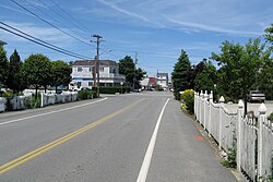
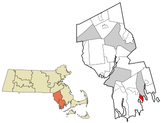
Ocean Bluff-Brant Rock is a census-designated place (CDP) in Plymouth County, Massachusetts, United States, composed of the neighborhoods of Ocean Bluff, Brant Rock, Fieldston, and Rexhame in the town of Marshfield. The population of the CDP was 4,970 at the 2010 census.

<span class="mw-page-title-main">Cedar Crest, New Mexico</span> Census-designated place in New Mexico, United States

Cedar Crest is a census-designated place (CDP) in Bernalillo County, New Mexico, United States. The population was 958 at the 2010 census. It is part of the Albuquerque Metropolitan Statistical Area.

<span class="mw-page-title-main">Cedar Crest, Oklahoma</span> CDP in Oklahoma, United States

Cedar Crest is a census-designated place (CDP) in Mayes County, Oklahoma, United States. The population was 312 at the 2010 census, almost unchanged from the figure of 308 recorded in 2000.

<span class="mw-page-title-main">La Plant, South Dakota</span> Census-designated place in South Dakota, United States

La Plant is a census-designated place (CDP) in Dewey County, South Dakota, United States. The population was 167 at the 2020 census. It is within the Cheyenne River Indian Reservation.

<span class="mw-page-title-main">Neilton, Washington</span> Census-designated place in Washington, United States

Neilton is an unincorporated community and census-designated place (CDP) in Grays Harbor County, Washington, United States. The population was 315 at the 2010 census.

<span class="mw-page-title-main">Rowley (CDP), Massachusetts</span> Census-designated place in Massachusetts, United States

Rowley is a census-designated place (CDP) in the town of Rowley in Essex County, Massachusetts, United States. The population was 1,416 at the 2010 census.

<span class="mw-page-title-main">Salisbury (CDP), Massachusetts</span> Census-designated place in Massachusetts, United States

Salisbury is a census-designated place (CDP) in the town of Salisbury in Essex County, Massachusetts, United States. The population was 4,869 at the 2010 census.

<span class="mw-page-title-main">Duxbury (CDP), Massachusetts</span> Census-designated place in Massachusetts, United States

Duxbury is a census-designated place (CDP) in the town of Duxbury in Plymouth County, Massachusetts, United States. The population was 1,802 at the 2010 census.

<span class="mw-page-title-main">Hingham (CDP), Massachusetts</span> Census-designated place in Massachusetts, United States

Hingham is a census-designated place (CDP) in the town of Hingham in Plymouth County, Massachusetts, United States. The population was 5,650 at the 2010 census.

<span class="mw-page-title-main">Marshfield (CDP), Massachusetts</span> Census-designated place in Massachusetts, United States

Marshfield is a census-designated place (CDP) in the town of Marshfield in Plymouth County, Massachusetts, United States. The population was 4,335 at the 2010 census.

<span class="mw-page-title-main">Plymouth Center, Massachusetts</span> Census-designated place in Massachusetts, United States

Plymouth is a census-designated place (CDP) in the town of Plymouth in Plymouth County, Massachusetts, United States. It is often referred to as Downtown Plymouth or Plymouth Center. The population was 7,494 at the 2010 census.

<span class="mw-page-title-main">Webster (CDP), Massachusetts</span> CDP in Massachusetts, United States

Webster is a census-designated place (CDP) in the town of Webster in Worcester County, Massachusetts, United States. The population was 11,412 at the 2010 census.

References

  1. "Zipcode 02041 Map" . Retrieved 2019-01-25.
  2. "Profile of General Population and Housing Characteristics: 2010 Demographic Profile Data (DP-1): Green Harbor-Cedar Crest CDP, Massachusetts". United States Census Bureau . Retrieved March 22, 2012.
  3. "US Gazetteer files: 2010, 2000, and 1990". United States Census Bureau. 2011-02-12. Retrieved 2011-04-23.
  4. "U.S. Census website". United States Census Bureau . Retrieved 2008-01-31.