Farmington is a town in Kent County, Delaware, United States. It is part of the Dover, Delaware Metropolitan Statistical Area. The population was 110 at the 2010 census.
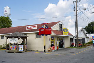
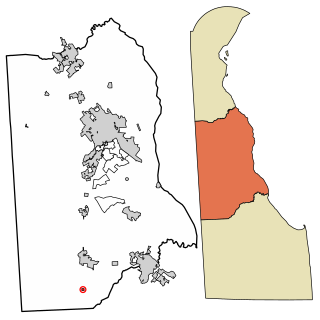
Harrington is a city in Kent County, Delaware, United States. It is part of the Dover, Delaware Metropolitan Statistical Area. Harrington hosts the annual Delaware State Fair each July. The population was 3,562 at the 2010 census.

Viola is a town in Kent County, Delaware, United States. It is part of the Dover, Delaware Metropolitan Statistical Area. The population was 157 at the 2010 census.

Woodside is a town in Kent County, Delaware, United States. It is part of the Dover, Delaware Metropolitan Statistical Area. The population was 181 at the 2010 census.
Claymont is a census-designated place (CDP) in New Castle County, Delaware, United States. The estimated 2017 population of the 19703 ZIP code, which Claymont encompasses, was 15,292.

Elsmere is a town in New Castle County, Delaware, United States, bordering the city of Wilmington along Wilmington's western border. According to the 2010 Census, the population of the town is 6,131.

Townsend is a town in New Castle County, Delaware, United States. The population was 2,049 at the 2010 census, an increase of 492.2% from 2000. The center of population of Delaware is located in Townsend.

Powell is a city in the U.S. state of Ohio, located 14 miles (21.5 km) north of the state capital of Columbus. The city is located in Delaware County; a frequent placeholder on the List of highest-income counties in the United States, and 35th wealthiest county in the United States in 2020. Powell had an estimated population of 13,375 in 2019, up from 11,500 at the 2010 census. Founded in the early 1800s, it is now a growing suburb of Columbus. Per the U.S. Census Bureau, 73.5% of Powell residents over the age of 25 are college graduates, the median home value is $372,700, and the median household income is $157,149. In 2018, the median list price of a home within the City of Powell was $411,173.
Brandywine Hundred is an unincorporated subdivision of New Castle County, Delaware, United States. It is located to the north and northeast of the city of Wilmington. Hundreds were once used as a basis for representation in the Delaware General Assembly. Brandywine Hundred and North Wilmington are commonly used colloquial names for this area. However, while their names still appear on all real estate transactions, all other hundreds in Delaware presently have no meaningful use or purpose except as a geographical point of reference. In the 2010 census, Brandywine had 77,182 people.

The Harrisburg Subdivision is a railroad line owned by CSX Transportation in the U.S. state of Pennsylvania. The line is located in the city of Philadelphia, connecting Greenwich Yard and the Philadelphia Subdivision with the Trenton Subdivision along a former Pennsylvania Railroad line. Much of the Harrisburg Subdivision is the High Line or West Philadelphia Elevated along 31st Street over the 30th Street Station area.

Gwinhurst is an unincorporated community in New Castle County, Delaware, United States. Its altitude is 98 feet (30 m), and it is located at 39°47′30″N75°28′44″W. It was established in 1919.

Delaware Route 12 (DE 12) is a state highway in Kent County, Delaware, United States. It runs from Maryland Route 314 (MD 314) at the Maryland border in Whiteleysburg east to an interchange with DE 1 near Frederica. The route follows a mostly rural alignment, passing through the towns of Felton and Frederica. DE 12 intersects U.S. Route 13 (US 13) in Felton and DE 15 east of Felton. What would become DE 12 was built as a state highway during the 1920s. DE 12 was designated between Felton and Frederica by 1936 and extended west to the Maryland border by 1938. The eastern terminus was moved to its current location in 1965 when US 113 was routed to bypass Frederica to the east. The DE 1 intersection became an interchange in 2011.

Delaware Route 62 (DE 62) is a state highway in New Castle County, Delaware in the United States. The route runs from DE 2 and the southern terminus of DE 41 in Prices Corner east to a dead end near Newport; however, DE 62 signage ends at the DE 4 intersection. The road runs through suburban areas along Newport Gap Pike and Boxwood Road, meeting DE 141 at an interchange. The Newport Gap Pike portion of road was built as a state highway by 1925 and became part of DE 41 by 1936. Boxwood Road was improved in 1946. DE 62 was assigned to its current alignment by 1981.

Delaware Township is one of twelve townships in Delaware County, Indiana. According to the 2010 census, its population was 3,603 and it contained 1,648 housing units.

Hamilton Township is one of twelve townships in Delaware County, Indiana. According to the 2010 census, its population was 7,206 and it contained 2,950 housing units.
Talleyville is an unincorporated community in New Castle County, Delaware, United States. Talleyville is located at the intersection of U.S. Route 202, Mt. Lebanon Road, and Silverside Road to the north of Wilmington. Its ZIP code is 19803.
Edenridge is an unincorporated community in New Castle County, Delaware, United States, west of Concord Pike and east of Brandywine Creek State Park. Edenridge is located east of the intersection of Mt. Lebanon Road and Sharpley Road southwest of Talleyville. It, like neighboring Sharpley, Woodbrook and Tavistock, was developed by Woodlawn Trustees. Husbands Run, a tributary of Brandywine Creek, rises in the park between them. When originally conceived in the mid-1960s the neighborhood was 11 streets laid out on 52 acres. It is part of the ZIP Code Tabulation Area for 19803.

Woodbrook is a suburban community in New Castle County, Delaware, United States.
Jimtown is an unincorporated community in Sussex County, Delaware, United States.
Hillcrest is an unincorporated community in New Castle County, Delaware, United States. Hillcrest is located east of Marsh Road between Delaware Route 3 and U.S. Route 13 Business north of Edgemoor. It was established in 1903.


