Alaska is a U.S. state in the northwest extremity of North America, just across the Bering Strait from Asia. The Canadian province of British Columbia and territory of Yukon border the state to the east, its most extreme western part is Attu Island, and it has a maritime border with Russia to the west across the Bering Strait. To the north are the Chukchi and Beaufort seas—southern parts of the Arctic Ocean. The Pacific Ocean lies to the south and southwest. It is the largest state in the United States by area and the seventh largest subnational division in the world. In addition, it is the 3rd least populous and the most sparsely populated of the 50 United States; nevertheless, it is by far the most populous territory located mostly north of the 60th parallel in North America: its population—estimated at 738,432 by the United States Census Bureau in 2015— is more than quadruple the combined populations of Northern Canada and Greenland. Approximately half of Alaska's residents live within the Anchorage metropolitan area. Alaska's economy is dominated by the fishing, natural gas, and oil industries, resources which it has in abundance. Military bases and tourism are also a significant part of the economy.

Traffic on roads consists of road users including pedestrians, ridden or herded animals, vehicles, streetcars, buses and other conveyances, either singly or together, while using the public way for purposes of travel. Traffic laws are the laws which govern traffic and regulate vehicles, while rules of the road are both the laws and the informal rules that may have developed over time to facilitate the orderly and timely flow of traffic.

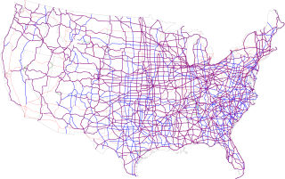
The Dwight D. Eisenhower National System of Interstate and Defense Highways, commonly known as the Interstate Highway System, is a network of controlled-access highways that forms part of the National Highway System in the United States. The system is named for President Dwight D. Eisenhower, who championed its formation. Construction was authorized by the Federal Aid Highway Act of 1956, and the original portion was completed 35 years later, although some urban routes were cancelled and never built. The network has since been extended. In 2016, it had a total length of 48,181 miles (77,540 km). As of 2016, about one-quarter of all vehicle miles driven in the country use the Interstate system. In 2006, the cost of construction was estimated at about $425 billion.

The United States Numbered Highway System is an integrated network of roads and highways numbered within a nationwide grid in the contiguous United States. As the designation and numbering of these highways were coordinated among the states, they are sometimes called Federal Highways, but the roadways were built and have always been maintained by state or local governments since their initial designation in 1926.

A toll road, also known as a turnpike or tollway, is a public or private road for which a fee is assessed for passage. It is a form of road pricing typically implemented to help recoup the cost of road construction and maintenance.

The contiguous United States or officially the conterminous United States consists of the 48 adjoining U.S. states on the continent of North America. The terms exclude the non-contiguous states of Alaska and Hawaii, and all other off-shore insular areas. These differ from the related term continental United States which includes Alaska but excludes Hawaii and insular territories.

Hampton is an independent city in the Commonwealth of Virginia in the United States. As of the 2010 census, the population was 137,436.

Chesapeake is an independent city in the Commonwealth of Virginia. As of the 2010 census, the population was 222,209; in 2013, the population was estimated to be 232,977, making it the third-most populous city in Virginia.

Hidalgo County is a county in the U.S. state of Texas. As of the 2017 census, the population was 860,661, making it the eighth-most populous county in Texas. The county seat is Edinburg and the largest city is McAllen. The county is named for Miguel Hidalgo y Costilla, the priest who raised the call for Mexico's independence from Spain.

Perry County is a county located in the southwestern part of the U.S. state of Indiana. As of 2010, the population was 19,338. The county seat is Tell City. It is the hilliest county as well as one of the most forested counties in Indiana as it features more than 60,000 acres (240 km2) of Hoosier National Forest. The Ohio River Scenic Byway along Indiana State Road 66 runs along the southern border of the county while Interstate 64 traverses the northern portion of the county. Connecting the two is Indiana State Road 37.

Madison County is a county located in the U.S. state of Indiana. As of 2015, the population was 129,723. The county seat is Anderson.

Pickens County is a county located in the north central portion of the U.S. state of Georgia. As of the 2010 census, the population was 29,431. The county seat is Jasper.

The Twenty-sixth United States Congress was a meeting of the legislative branch of the United States federal government, consisting of the United States Senate and the United States House of Representatives. It met in Washington, D.C. from March 4, 1839, to March 4, 1841, during the third and fourth years of Martin Van Buren's presidency. The apportionment of seats in the House of Representatives was based on the Fifth Census of the United States in 1830. Both chambers had a Democratic majority.
A state highway, state road, or state route is usually a road that is either numbered or maintained by a sub-national state or province. A road numbered by a state or province falls below numbered national highways in the hierarchy. Roads maintained by a state or province include both nationally numbered highways and un-numbered state highways. Depending on the state, "state highway" may be used for one meaning and "state road" or "state route" for the other.

The Federal Highway Administration (FHWA) is a division of the United States Department of Transportation that specializes in highway transportation. The agency's major activities are grouped into two programs, the Federal-aid Highway Program and the Federal Lands Highway Program. Its role had previously been performed by the Office of Road Inquiry, Office of Public Roads and the Bureau of Public Roads.

The National Highway System (NHS) is a network of strategic highways within the United States, including the Interstate Highway System and other roads serving major airports, ports, rail or truck terminals, railway stations, pipeline terminals and other strategic transport facilities. Altogether, it constitutes the largest highway system in the world.

The United States competed at the 1928 Summer Olympics in Amsterdam, Netherlands. 280 competitors, 236 men and 44 women, took part in 96 events in 15 sports.

A street circuit is a motorsport racing circuit composed of temporarily closed-off public roads of a city, town or village, used in motor races. Facilities such as the paddock, pit boxes, fences and grandstands are usually placed temporarily and removed soon after the race is over but in modern times the pits, race control and main grandstands are sometimes permanently constructed in the area. Since the track surface is originally planned for normal speeds, race drivers often find street circuits bumpy and lacking grip. Run-off areas may be non-existent, which makes driving mistakes more expensive than in purpose-built circuits with wider run-off areas. Racing on a street circuit is also called "legal street racing".
Highways in the United States are split into at least four different types of systems: Interstate Highways, U.S. Highways, state highways, and county highways. Highways are generally organized by a route number or letter. These designations are generally displayed along the route by means of a highway shield. Each system has its own unique shield design that will allow quick identification to which system the route belongs. Below is a list of the different highway shields used throughout the United States.

Ross William Ulbricht is a convicted American darknet market operator and narcotics trafficker, best known for creating and running the Silk Road website from 2011 until his arrest in 2013. He was known under the pseudonym "Dread Pirate Roberts," after the fictional character in the novel The Princess Bride (1973) and its 1987 film adaptation.


