
Delaware is a state in the Mid-Atlantic region of the United States, bordering Maryland to its south and west; Pennsylvania to its north; and New Jersey and the Atlantic Ocean to its east. The state takes its name from the nearby Delaware River named after Thomas West, 3rd Baron De La Warr, an English nobleman and Virginia's first colonial governor.

The Delaware River is a major river on the Atlantic coast of the United States. It drains an area of 13,539 square miles (35,070 km2) in four U.S. states: Delaware, New Jersey, New York and Pennsylvania. Rising in two branches in New York state's Catskill Mountains, the river flows 419 miles (674 km) into Delaware Bay where its waters enter the Atlantic Ocean near Cape May in New Jersey and Cape Henlopen in Delaware. Not including Delaware Bay, the river's length including its two branches is 388 miles (624 km). The Delaware River is one of nineteen "Great Waters" recognized by the America's Great Waters Coalition.
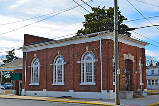
Frederica is a town in Kent County, Delaware, United States. It is part of the Dover, Delaware Metropolitan Statistical Area. The population was 774 at the 2010 census. ILC Dover, the company which manufactured the spacesuits for the Apollo and Skylab astronauts of the 1960s and 1970s, along with fabricating the suit component of the Space Shuttle's Extravehicular Mobility Unit (EMU), is located nearby.

Viola is a town in Kent County, Delaware, United States. It is part of the Dover, Delaware Metropolitan Statistical Area. The population was 157 at the 2010 census.

Delaware City is a city in New Castle County, Delaware, United States. The population was 1,695 at the 2010 census. It is a small port town on the eastern terminus of the Chesapeake and Delaware Canal and is the location of the Forts Ferry Crossing to Fort Delaware on Pea Patch Island.

Newark is a city in New Castle County, Delaware, United States. It is located 12 miles (19 km) west-southwest of Wilmington. According to the 2010 Census, the population of the city is 31,454. Newark is home to the University of Delaware.
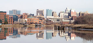
Wilmington is the largest and most populous city in the U.S. state of Delaware. The city was built on the site of Fort Christina, the first Swedish settlement in North America. It lies at the confluence of the Christina River and Brandywine River, near where the Christina flows into the Delaware River. It is the county seat of New Castle County and one of the major cities in the Delaware Valley metropolitan area. Wilmington was named by Proprietor Thomas Penn after his friend Spencer Compton, Earl of Wilmington, who was prime minister during the reign of George II of Great Britain.

Bridgeville is a town in Sussex County, Delaware, United States. According to the 2010 census, the population is 2,048, an increase of 42.6% from the previous decade. It is part of the Salisbury, Maryland-Delaware Metropolitan Statistical Area.

Delmar is a town in Sussex County, Delaware, United States, on the Maryland border along the Transpeninsular Line. Its motto is "The Little Town Too Big for One State." The population was 1,597 at the 2010 census, an increase of 13.5% over the previous decade. It is part of the Salisbury, Maryland-Delaware Metropolitan Statistical Area and a suburb of Salisbury, MD. When added with Delmar, Maryland, the total population of the town was 4,600 at the 2010 Census.
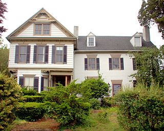
Laurel is a town in Sussex County, Delaware. The population was 3,708 at the time of the 2010 census. Laurel is part of the Salisbury, Maryland-Delaware Metropolitan Statistical Area. It once hosted the Laurel Blue Hens of the Eastern Shore Baseball League.

South Bethany is an incorporated town in Sussex County, Delaware, United States. According to the 2010 census, the population of the town is 449, a decrease of 8.7% over the previous decade. It is part of the Salisbury, Maryland-Delaware Metropolitan Statistical Area.
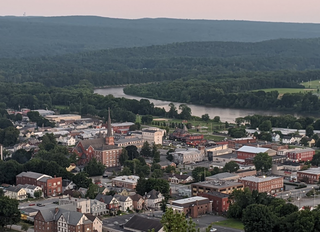
Port Jervis is a city located at the confluence of the Neversink and Delaware rivers in western Orange County, New York, north of the Delaware Water Gap. Its population was 8,828 at the 2010 census. The communities of Deerpark, Huguenot, Sparrowbush, and Greenville are adjacent to Port Jervis. Matamoras, Pennsylvania, is across the river and connected by bridge. Montague Township, New Jersey, borders here.

Delaware is a city in and the county seat of Delaware County, Ohio, United States. Delaware was founded in 1808 and was incorporated in 1816. It is located near the center of Ohio, is about 30 miles (48 km) north of Columbus, and is part of the Columbus, Ohio metropolitan area. The population was 34,753 at the 2010 census, while the Columbus-Marion-Chillicothe, OH Combined Statistical Area has 2,002,604 people.

The Delaware Valley is the valley through which the Delaware River flows. By extension, this toponym is commonly used to refer to Greater Philadelphia or the Philadelphia metropolitan area. The Delaware Valley is coterminous with a metropolitan statistical area (MSA) and broader combined statistical area (CSA), and is composed of counties located in Southeastern Pennsylvania, South Jersey, Delaware, and the Eastern Shore of Maryland. As of the 2010 Census, the MSA has a population of over 6 million, while the CSA has a population of over 7.1 million.

Gebhart v. Belton, 33 Del. Ch. 144, 87 A.2d 862, aff'd, 91 A.2d 137, was a case decided by the Delaware Court of Chancery in 1952 and affirmed by the Delaware Supreme Court in the same year. Gebhart was one of the five cases combined into Brown v. Board of Education, the 1954 decision of the United States Supreme Court which found unconstitutional racial segregation in United States public schools.

Bridesburg, the northernmost of Philadelphia's River Wards, is a river-front neighborhood in the Northeast section of Philadelphia, Pennsylvania, United States. Bridesburg is an historically German and Irish community, with a significant community of Polish immigrants who arrived mostly in the early- to mid-twentieth century. The community is home to two Catholic churches: All Saints Church, designed by Edwin Forrest Durang, built in 1889; and Saint John Cantius Church, built some time after 1892 in Polish Cathedral style.

Bearpen Mountain is a mountain located in the Catskill Mountains of New York. The mountain's highest peak is in Greene County, but its northwest subpeak at 42°16.42′N74°29.05′W is the highest point in Delaware County at 3,520 ft. Bearpen Mountain is flanked to the north by Roundtop, and to the southeast by Vly Mountain.
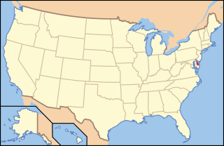
The following is an alphabetical list of articles related to the U.S. state of Delaware.


