
Kingston upon Thames is a town in Royal Borough of Kingston Upon Thames, Greater London, England. It is situated on the River Thames and 10 miles (16 km) southwest of Charing Cross. It is notable as the ancient market town in which Saxon kings were crowned and today is the administrative centre of the Royal Borough.

Guildford is the county town of Surrey, England. It lies 28 miles (45 km) southwest of London on the A3 trunk road between the capital and Portsmouth. As of the 2011 census, the town has a population of about 80,000 and is the seat of the wider Borough of Guildford which had an estimated 147,889 inhabitants in 2018.

Chessington is an area in the Royal Borough of Kingston upon Thames within Greater London. Historically part of Surrey, today it is the largest salient of Greater London into that county. As of the 2011 Census it had a population of 18,973. The Bonesgate Stream, a tributary of the Hogsmill River, runs through it. The popular theme park resort Chessington World of Adventures, which incorporates Chessington Zoo, is located in the south-west of the area.

Coulsdon is a town in south London, England, within the London Borough of Croydon and the historic county of Surrey.
Tolworth is a suburban area in the Surbiton district, Royal Borough of Kingston upon Thames, Greater London. It is 11 miles (17.7 km) southwest of Charing Cross. Neighbouring places include Long Ditton, New Malden, Kingston, Surbiton, Berrylands, Hinchley Wood, Chessington, Ewell and Worcester Park. Surbiton is the nearest, about a mile to the northwest. Tolworth is divided in two by the A3 Kingston Bypass and is situated slightly north of the Greater London-Surrey border.
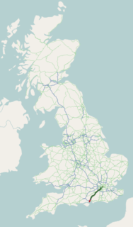
The A3, known as the Portsmouth Road or London Road in sections, is a major road connecting the City of London and Portsmouth passing close to Kingston upon Thames, Guildford, Haslemere and Petersfield. For much of its 67-mile (108 km) length, it is classified as a trunk road and therefore managed by Highways England. Almost all of the road has been built to dual carriageway standards or wider. Apart from bypass sections in London, the road travels in a southwest direction and, after Liss, south-southwest.

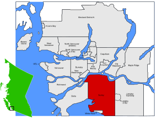
Surrey is a city in the province of British Columbia, Canada, located south of the Fraser River and north of the Canada–United States border. It is a member municipality of the Metro Vancouver regional district and metropolitan area. Mainly a suburban city, Surrey is the province's second-largest by population after Vancouver and the third-largest by area after Abbotsford and Prince George. Seven neighbourhoods in Surrey are designated town centres: Cloverdale, Fleetwood, Guildford, Newton, South Surrey, and City Centre encompassed by Whalley.

Oatlands is a village in the north of the English county of Surrey on low, verdant ridges partially overlooking the River Thames. Oatlands acquired its name from the Royal Tudor and Stuart Oatlands Palace, the site of which is now a luxury hotel. Before acquiring its first place of worship it was part of Walton on Thames, and shortly after thereby becoming a village did not qualify for post town status and instead its post town became Weybridge. The towns it adjoins have their centres 1 mile (1.6 km) away. Oatlands has a park, parade of shops, one pub, one Working Men's Club, and three schools.

Egham is a university town in the Borough of Runnymede in Surrey, England, approximately 19 miles (31 km) west of central London. First settled in the Bronze Age, the town was under the control of Chertsey Abbey for much of the Middle Ages. In 1215, Magna Carta was sealed by King John at Runnymede, to the north of Egham, having been chosen for its proximity to the King’s residence at Windsor. Under the Dissolution of the Monasteries in the early 16th Century, the major, formerly eccesiastical, manorial freehold interests in the town and various market revenues passed to the Crown.

Surrey Hills is a suburb of Melbourne, Victoria, Australia, 11 km east of Melbourne's Central Business District. Its local government area are the Cities of Boroondara and Whitehorse. At the 2016 census, Surrey Hills had a population of 13,605. The median age was 40 years old.

White Rock is a city in British Columbia, Canada, and a member municipality of the Metro Vancouver Regional District. It borders Semiahmoo Bay to the south and is surrounded on three sides by Surrey. To the southeast across a footbridge lies the Semiahmoo First Nation, which is within the borders of Surrey. Semiahmoo Bay and the Southern Gulf Islands in the Strait of Georgia are also to the south.
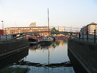
The Grand Surrey Canal was a canal constructed in south London, England during the early 19th century. It opened to the Old Kent Road in 1807, to Camberwell in 1810, and to Peckham in 1826. Its main purpose was to transport cargo, primarily timber from the Surrey Commercial Docks.

Artington is a village and civil parish in the borough of Guildford, Surrey, England. It covers the area from the southern edge of the built-up centre of Guildford and steep Guildown, the start of the Hog's Back and part of the North Downs AONB, to New Pond Farm by Godalming and the edge of Peasmarsh. It contains Loseley Park, a country estate with dairy, and the hamlet of Littleton.

Camberley Town Football Club is a semi-professional football based in Camberley, Surrey, England. They are currently members of the Combined Counties League Premier Division South and play at Krooner Park.
Stoneleigh is a suburb of southwest London, occupying most of the northern part of the borough of Epsom and Ewell in Surrey, England, approximately 11 miles (18 km) from central London. In the 2011 Census, the population was 8741.

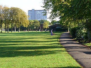
Old Deer Park is an area of open space within Richmond, owned by the Crown Estate, in the London Borough of Richmond upon Thames, England. It covers 147 hectares of which 90.4 hectares are leased as sports grounds for sports, particularly rugby and golf. Despite the name, there are now no deer in the park.
Sunnyside is a neighbourhood of South Surrey, which in turn is a region of Surrey, British Columbia, Canada.
Sutton Common is the name of former common land and a district and neighbourhood located in Sutton, London. The area is mostly located within the London Borough of Sutton, with some of the streets to the north and west of Sutton Common Park adjoining Lower Morden and Morden within the London Borough of Merton. Much of the area is taken up by the large Kimpton Park commercial and industrial estate, adjoining the A217. It is served by Sutton Common railway station. The area to the south and east of Oldfields Road uses an SM1 postcode and the area to the north and west uses SM3.
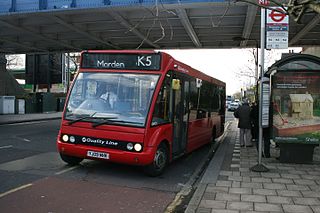
London Buses route K5 is a Transport for London contracted bus route in London, England. Running between Morden station and Ham, it is operated by London United.


