
Pietà is a small harbour town in the Eastern Region of Malta, located near the outskirts of the capital city Valletta.

Rabat is a town in the Western Region of Malta, with a population of 11,497 as of March 2014. It adjoins the ancient capital city of Mdina, and a north-western area formed part of the Roman city of Melite until its medieval retrenchment.

Żurrieq is a town in the Southern Region of Malta. It is one of the oldest towns in the country, and has a population of 11,823 inhabitants as of March 2014. Żurrieq is one of the 10 parishes to be documented in 1436 and is dedicated to Saint Catherine. The island of Filfla is administratively a part of the town. The town stretches from Nigret to Ħal Far. In old times the town had a border with Żejtun. The village of Qrendi used to be part of the parish of Żurrieq until 1618 when it was made into its own parish.

Żebbuġ is a village and an administrative unit of Malta, in the northwest coast of the island of Gozo. It is located close to Għarb and Għasri and is built on two hilltop plateaus, Ta' Abram and Ix-Xagħra taż-Żebbuġ. The fishing port and tourist resort of Marsalforn lies within the Żebbuġ Council. The village has a population of 2,956, which makes it the fifth largest in Gozo, after Xewkija.

Safi is a village in the Southern Region of Malta, bordering Żurrieq and Kirkop. It has a population of 2,126 people as of March 2014.

San Ġwann is a town in the Northern Region of Malta, with a population of 14,244 as of 2021. Prior to its establishment as a distinct municipality, it was a fragmented community comprising parts of Birkirkara and St. Julian's. San Ġwann emerged as a new parish in 1965 and was officially recognised as a town in 1968. The Local Councils Act of 1993 identified San Gwann as a separate district with its own statutory local government authority, marking its transition from being part of the neighbouring localities. With the first San Gwann Council was elected on 16 April 1994.

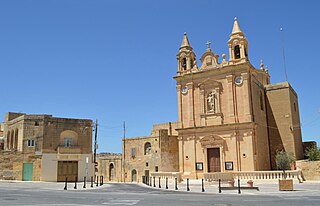
Għajnsielem, meaning "Spring of Sielem", is a municipality on the southeastern coast of the island of Gozo in Malta, including the entire island of Comino. It has a population of 3,200 residents, and is the first Gozitan village that greets the visitor on leaving Mġarr Harbour towards the Gozitan heartland. Its name originated from the water spring, around which in 1700, Grandmaster Perellos built an arcade containing public wash basins and fresh water spouts. Attractions include Lourdes Chapel with its sharp steeple and underlying niche of Our Lady of Lourdes, Fort Chambray and the towering of Ghajnsielem Parish Church.
Munxar is an administrative unit of Malta, which lies on the southern side of the island of Gozo. As of March 2014, its population was 1,454 people.

Qala is an administrative unit of Malta, on the island of Gozo, with a population of 1,929 as of September 2019. Nearby is Ħondoq ir-Rummien, a coastline with salt pans and caves.

San Lawrenz is an administrative unit of Malta, on the island of Gozo. Its name is derived from Lawrence of Rome who is the patron saint for the locality. It has a population of 748, as of March 2014.
Sannat is an administrative unit of Malta, on the island of Gozo, with a population of 2,117 people. Ta' Sannat is in the south of Gozo, popular for its very high cliffs, ancient cart ruts, temples and dolmens, and rich fauna and flora. In 1951 The Duchess of Edinburgh of the United Kingdom visited a house called "The Lace house" located in a small square in Ta' Sannat called "Pjazza Tax-Xelina".

Bidnija is a rural hamlet between Mosta, St. Paul's Bay and Mġarr. It is located in the northern region of Malta and is home to roughly 308 people as of 2008, the second least populated habitable zone on the Maltese islands after Mdina. It is located between two main valleys then extends into other small valleys surrounding the area. It is largely a rural village surrounded by fields mainly belong to the inhabitants, although over the years other Maltese and foreigners have settled in the area generally for its countryside views.

Baħrija is a village in Rabat, Malta, with a low population density. The name Baħrija means moth in Maltese. It is also known in English as Baħria, of which the Counts Moscati had owned the fiefdom that was granted by the Grand Master of Malta.

Malta is for non-local government purposes divided into districts as opposed to the local government regions at the same level. The three main types of such districts – statistical, electoral at national level, and policing – have no mainstream administrative effect as the regions and local councils function as the only administrative divisions of the country.

The coastline of Malta consists of bays, sandy beaches, creeks, harbours, small villages, cities, cliffs, valleys, and other interesting sites. Here, there is a list of these different natural features that are found around the coast of Malta.

In Malta, most of the main roads are in the outskirts of the localities to connect one urban area with another urban area. The most important roads are those that connect the south of the island with the northern part, like Tal-Barrani Road, Aldo Moro Street in Marsa and Birkirkara Bypass.

Gozo Region is one of five regions of Malta. The region includes the islands of Gozo, Comino and several little islets such as Cominotto. The region does not border any other regions, but it is close to the Northern Region.


