Mġarr

Last updated • 6 min readFrom Wikipedia, The Free Encyclopedia

Mġarr
L-Imġarr
Mgarr Malta.jpg
View of Mġarr
Flag of Mgarr.svg
Mgarr Malta COA.jpg
Motto(s): 
Raħal żgħir b'qalb kbira
(A small town with a caring heart)
Mgarr in Malta.svg
Coordinates: 35°55′11″N14°21′59″E / 35.91972°N 14.36639°E / 35.91972; 14.36639
Country Flag of Malta.svg  Malta
Region Northern Region
District Northern District
Borders Mellieħa, Mosta, Rabat, St. Paul's Bay
Government
   Mayor Paul Vella (PN)
Area
  Total
16.1 km2 (6.2 sq mi)
Population
 (2021)
  Total
4,840
  Density300/km2 (780/sq mi)
Demonym(s) Mġarri (m), Mġarrija (f), Mġarrin (pl)
Time zone UTC+1 (CET)
  Summer (DST) UTC+2 (CEST)
Postal code
MGR
Dialing code 356
ISO 3166 code MT-31
Patron saint Santa Marija
Day of festa 1st Sunday after 15 August
Website Old Official website
Local Council Website

Mġarr (Maltese : L-Imġarr), formerly known as Mgiarro, is a village in the Northern Region of Malta. Mġarr is a rural village, isolated from nearby towns and cities. Mġarr lies west of Mosta and is surrounded by farmland and vineyards. Many of the 4,840 [1] Imġarrin are farmers or otherwise engaged in agricultural activity.

Contents

History

Prehistory

The Ta' Skorba Temples are the earliest remains of human occupation in Mġarr, dating back to the Neolithic Għar Dalam phase of Maltese Prehistory. It is believed that they settled in Mġarr because of the fields, hills and water streams. [2] Skorba was excavated in the early 1960s. [3]

The Ta' Ħaġrat Temples was built in two phases. The minor Saflieni Phase temple can be entered from the major temple, and was built by smaller rocks. The Ġgantija Phase temple consisted of the rest of the temple, including the majestic entrance. [4] These temples were discovered in 1917 and excavated between 1923 and 1926 by Sir Temi Zammit. The site was again excavated in 1954 and in 1961. [5]

Punic and Roman Rule

Punic Tombs are found scattered around Mġarr, including in Abbatija and near Skorba. These prove that human occupation in Mġarr lasted till around the last century BC. [6] Around 33 Punic Tombs have been found in Mġarr. [7]

The Binġemma Tombs, known as Għerien il-Lhud (English: Jewish Caves) are dug into the Dwejra Hill. These have suffered considerable damage since the cave was used as a dwelling, to house animals and as a war shelter. There are various speculations about what these tombs were for. The Catacombs in Tar-Ragħad show the standing of early Roman Catholics in Malta.

The Roman Villa in Ras ir-Raħeb was apparently used as a site for sacred rites. The Għajn Tuffieħa Roman Baths nearby were erected approximately during the 1st or 2nd century AD. Various rooms including for hot baths, cold baths and relaxation were found. Rooms seem to have been added to be used for recreation.

From the 4th century onwards, there is no concrete proof of what happened in the Mġarr area. During the Arab period, it can only be assumed that small settlements might have persisted in areas like tan-Nadur, ta' Binġemma and tas-Santi, since they were concealed by the hills. [8]

Norman and Hospitaller Rule

Once the Normans conquered Malta and gradually gained full control of it, commerce in the Fomm ir-Riħ, Ġnejna, and Għajn Tuffieħa ports rose. Cotton, cumin and vineyards were also grown to generate income. Ever since 1419, watchmen were assigned to ensure that products were not stolen or looted. Parts of Binġemma and Santi during these times were sold as feudal lands. [9]

Mġarr also played a role in the Great Siege of Malta. The Ottoman invading army, led by Mustafa Pasha anchored their ships in Mġarr. [10] Men from Mġarr also formed part of the Naxxar Dejma Company. [11]

Churches

Assumption of the Blessed Virgin Mary Parish Church

One of the earliest mentions of the chapel predating the Parish Church that is standing today was in the Rollo of 1436. [12] The Church used to fall under various parishes, including Mdina, Naxxar and Mellieħa. It is understood that the chapel had been standing since the 1400s, and had major renovations in the 1600s to avoid it collapsing. However in 1918 the chapel was demolished and the Parish Church still standing today was built in its place. [13]

Mġarr and its surrounding zones became an autonomus Parish in 1898, when the population was around 581 and was rising steadily. [14] This led to the Parish Priest and the parishioners wishing to erect a larger church than the one currently present. Work on the new Parish Church started in 1905. Its construction depended heavily on voluntary work and the generous contributions obtained by parishioners from the sale of agricultural products. Despite efforts to speed up the work, the church was not completed until 1946. The Church was completely finished and consecrated in 1948, due to interruptions because of the Second World War, amongst others. [15]

The church is situated on elevated ground, offering a panoramic view of the surrounding fields and hills. Numerous houses still encompass the narrow streets surrounding the church, keeping the traditional feel of the church being the most imposing building of the town centre. This can especially be seen from the Binġemma area, where the church can be easily seen as the largest building in central Mġarr.

St Anne Church, Żebbiegħ

Chapel of Our Lady of Itria, Binġemma

Defunct Chapels

Education

Saint Nicholas College, Mġarr Primary School

The Mġarr Primary School was opened on 19 September 1923. Prior to its opening, only 1% of the population were literate in English and/or Italian, and only 4% were literate in Maltese. Fr Edgar Salomone worked hard and managed to influence the members of the newly elected Self Government in favour of the primary school. In 1946, Mġarr had the highest rate of school attendance nationally. [16]

Eventually, the school expanded and built new classes to accommodate the growth in the student population. It also joined the Saint Nicholas College network of schools.

San Andrea School

San Andrea School is a private school located in Mġarr. [17] The school was founded in 1992 in Naxxar. It was founded by the Parents Foundation of Education, who also founded San Anton School.

San Anton School

San Anton School is a private school located in Mġarr. [18] The school was founded in 1988 in the village of Attard, close to the President's San Anton Palace, giving the school its name. [19]

Local Groups

Mġarr United Football Club

Mġarr United F.C. was founded in 1967 after the disillusion of Mġarr Eagles F.C. The Club has had its fair share of successes, and is active in both training its club members and playing matches. [20]

Soċjetà Filarmonika Marija Mtellgħa s-Sema' L-Imġarr

The Santa Marija Mtellgħa s-Sema' Philharmonic Society was founded in October 2011. Preparations for the foundation of the band started before the 2011 Festa.

Apart from the Village Festa, the band also played during the possession ceremony of Mons Kalċidon Vassallo and Fr George Schembri as parish priest. The band also played in various local feasts outside of Imġarr. The band was also invited by the Italian Comune of Mathi in 2018, as the band's first service abroad. [21]

Soċjetà Spettaklu Marija Assunta Mġarr

The Society is responsible for the fireworks and spectacle events during the Village Festa and other events of local importance.

Government

The Mġarr Local Council was established by the Local Government Act of 1993, along with the other local councils of Malta. [22] The first election was held on 22 January 1994. Other elections were held in 1997, 2000, 2003, 2006, 2009, 2013, 2019 and 2024. The present local council was elected in 2024. The local council is housed in a building in Triq Sir Harry Luke.

The current Mġarr Local Council as elected by the residents in the 2024 Maltese local elections [23]

The following have served as Mayors of Mġarr: [24]

Transport

Malta Public Transport operates 3 bus routes that either depart from/ arrive to/ pass through Mġarr.

Routes that pass through Mġarr
Route NumberFromViaToFrequency
44Valletta Floriana, Pietá, Msida, Swatar, Birkirkara, Lija, Mosta, Żebbiegħ, Mġarr, Manikata Għajn TuffieħaEvery 30 minutes
101ĊirkewwaMarfa, Mellieħa, Manikata, Għajn Tuffieħa, Iż-ŻebbiegħMġarr [a] Every 1 hour
238Valletta [b]
Mater Dei [c]
Floriana, Pietá, Msida, Mater Dei, San Ġwann, Naxxar, Mosta, ŻebbiegħMġarrEvery 1 hour

Zones in Mġarr

Mġarr is not split into official zones, however the following zones are widely accepted as the main subdivisions of the town. [25]

Notable people

Twin towns – sister cities

Mġarr is twinned with: [26]

Notes

  1. In Summer, the route gets extended and stops at Ġnejna Bay.
  2. During weekdays, the route departs from Valletta.
  3. During weekends, the route departs from Mater Dei Hospital.

Related Research Articles

<span class="mw-page-title-main">Mellieħa</span> Local council in Northern Region, Malta

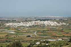
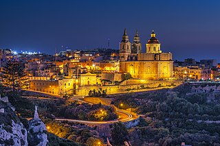
Mellieħa is a large village in the Northern Region of Malta. It has a population of 10,087 as of March 2014. Mellieħa is also a tourist resort, popular for its sandy beaches, natural environment, and Popeye Village nearby.

<span class="mw-page-title-main">Rabat, Malta</span> Local council in Western Region, Malta

Rabat is a town in the Western Region of Malta, with a population of 11,497 as of March 2014. It adjoins the ancient capital city of Mdina, and a north-western area formed part of the Roman city of Melite until its medieval retrenchment.

<span class="mw-page-title-main">San Ġwann</span> Local council in Northern Region, Malta

San Ġwann is a town in the Northern Region of Malta, with a population of 14,244 as of 2021. Prior to its establishment as a distinct municipality, it was a fragmented community comprising parts of Birkirkara and St. Julian's. San Ġwann emerged as a new parish in 1965 and was officially recognised as a town in 1968. The Local Councils Act of 1993 identified San Gwann as a separate district with its own statutory local government authority, marking its transition from being part of the neighbouring localities. With the first San Gwann Council was elected on 16 April 1994.

<span class="mw-page-title-main">Għajn Tuffieħa Tower</span>

Għajn Tuffieħa Tower is a small watchtower in Għajn Tuffieħa, limits of Mġarr, Malta. It was completed in 1637 as the second of the Lascaris towers. The tower is mostly intact although it is threatened by coastal erosion and was damaged during a storm in 2023.

<span class="mw-page-title-main">Iklin</span> Local council in Central Region, Malta

Iklin is a village in the Central Region of Malta, with a population of 3,247 as at 2021. Iklin was established in the mid-20th century; however some archaeological sites and a medieval chapel, named as St. Michael Chapel, are proof to earlier settlements. Until recently, the town was considered to form part of the Three villages of Malta, as part of Lija. With the separation of Iklin from Lija, Iklin is no longer part of the three villages. It is bordered by Għargħur, San Ġwann, Birkirkara, Balzan and Naxxar.

<span class="mw-page-title-main">Għajnsielem</span> Local council in Gozo Region, Malta

Għajnsielem is a municipality on the southeastern coast of the island of Gozo in Malta, including the entire island of Comino. It has a population of 3,200 residents, and is the first Gozitan village that greets the visitor on leaving Mġarr Harbour towards the Gozitan heartland. Its name originated from the water spring, around which in 1700, Grandmaster Perellos built an arcade containing public wash basins and fresh water spouts. Attractions include Lourdes Chapel with its sharp steeple and underlying niche of Our Lady of Lourdes, Fort Chambray and the towering of Ghajnsielem Parish Church.

<span class="mw-page-title-main">Qala, Malta</span> Local council in Gozo Region, Malta

Qala is an administrative unit of Malta, on the island of Gozo, with a population of 1,929 as of September 2019. Nearby is Ħondoq ir-Rummien, a coastline with salt pans and caves.

<span class="mw-page-title-main">Marsaskala</span> Local council in South Eastern Region, Malta

Marsaskala, sometimes written as Marsascala is a seaside town in the South Eastern Region of Malta. Originally a fishing village, it has grown into a tourist destination and a permanent hometown for an ever-growing population.

<span class="mw-page-title-main">Districts of Malta</span>

Malta is for non-local government purposes divided into districts as opposed to the local government regions at the same level. The three main types of such districts – statistical, electoral at national level, and policing – have no mainstream administrative effect as the regions and local councils function as the only administrative divisions of the country.

This page list topics related to Malta.

<span class="mw-page-title-main">Coastline of Malta</span>

The coastline of Malta consists of bays, sandy beaches, creeks, harbours, small villages, cities, cliffs, valleys, and other interesting sites. Here, there is a list of these different natural features that are found around the coast of Malta.

<span class="mw-page-title-main">Ġnejna Bay</span> Bay in Mġarr, Malta

Ġnejna Bay is a popular tourist destination located about 1 kilometer from the village of Mġarr on the western coast of Malta. The beach surrounding the bay is mostly sandy. A secluded strip of shore under the steep cliff on the northern side of the bay is a popular nudist beach, although the practice is technically illegal in Malta and frowned upon by the conservative Catholic population.

The Lascaris Towers are a series of mostly small coastal watchtowers built in Malta by the Order of Saint John between 1637 and 1652. The first seven towers were built around the coast of mainland Malta in 1637 and 1638. Between 1647 and 1652, a large tower was also built on mainland Malta, and two smaller ones were built on Gozo.

Post codes in Malta are seven-character strings that form part of a postal address in Malta. Post codes were first introduced in 1991 by the mail operator MaltaPost. Like those in the United Kingdom and Canada, they are alphanumeric.

<span class="mw-page-title-main">Roads in Malta</span>

In Malta, most of the main roads are in the outskirts of the localities to connect one urban area with another urban area. The most important roads are those that connect the south of the island with the northern part, like Tal-Barrani Road, Aldo Moro Street in Marsa and Birkirkara Bypass.

<span class="mw-page-title-main">Northern Region, Malta</span> Region of Malta

The Northern Region is one of six regions of Malta. The region includes the northwestern part of the main island of Malta. The region borders the Eastern, Southern and Western Regions, and is also close to Gozo Region.

<span class="mw-page-title-main">Parish Church of the Assumption, Mġarr</span> Church in Mġarr, Malta

The Parish Church of the Assumption of the Blessed Virgin Mary into Heaven is a Roman Catholic parish church in Mġarr, Malta, dedicated to the Assumption of Mary. It was constructed between 1912 and 1946 on the site of an earlier church which had existed since around 1400. The building has a large dome with an elliptical plan; this shape is said to have been chosen because of its similarity to an egg, so as to encourage residents to sell eggs to raise funds for its construction.

<span class="mw-page-title-main">Protected areas of Malta</span>

There are over 300 protected areas in Malta which have a wide range of national and international protection statuses.

References

  1. "Census of Population and Housing 2021: Preliminary Report". nso.gov.mt. Retrieved 7 December 2022.
  2. Deguara, Alwiġ (1999). L-Imġarr - Il-Ħajja u l-Ħidma ta' Niesu mill-Qedem sa llum. pp. 35–36. ISBN   99909-84-09-3.
  3. "Skorba Prehistoric Site". Heritage Malta.
  4. Deguara, Alwiġ (1999). L-Imġarr - Il-Ħajja u l-Ħidma ta' Niesu mill-Qedem sa llum. pp. 44–45. ISBN   99909-84-09-3.
  5. "Ta' Ħaġrat Megalithic Site". Heritage Malta.
  6. Deguara, Alwiġ (1999). L-Imġarr - Il-Ħajja u l-Ħidma ta' Niesu mill-Qedem sa llum. p. 53. ISBN   99909-84-09-3.
  7. Said-Zammit, George A. (1993). "The Punic tombs of the Maltese islands".
  8. Deguara, Alwiġ (1999). L-Imġarr - Il-Ħajja u l-Ħidma ta' Niesu mill-Qedem sa llum. ISBN   99909-84-09-3.
  9. Deguara, Alwiġ (1999). L-Imġarr - Il-Ħajja u l-Ħidma ta' Niesu mill-Qedem sa llum. ISBN   99909-84-09-3.
  10. "The first days of the Great Siege of Malta". Times of Malta. 15 May 2022.
  11. Cassar, George (2005). "The role of the Maltese inhabitants during the Great Siege". Sacra Militia Foundation.
  12. "Ir-Rollo 1436". Kappelli Maltin.
  13. "Mgarr Local Council - Churches & Chapels". mgarrlc.com.
  14. "After many difficulties, Mġarr parish church was completed 75 years ago". Times of Malta. 11 April 2023.
  15. Deguara, Alwiġ (1999). L-Imġarr - Il-Ħajja u l-Ħidma ta' Niesu mill-Qedem sa llum. pp. 127–142. ISBN   99909-84-09-3.
  16. "100 years of Mġarr primary school". Times of Malta. 19 September 2023.
  17. "Contact". San Andrea School.
  18. "Contact Us | San Anton School". www.sananton.edu.mt. Retrieved 7 April 2024.
  19. "San Anton School". www.sananton.edu.mt.
  20. "Mgarr United FC – founded in 1967".
  21. "Storja – Il-Banda tal-Imġarr". Soċjetà Filarmonika Marija Mtellgħa s-Sema'.
  22. "Att dwar Gvern Lokali". LEĠIŻLAZZJONI MALTA.
  23. "2024 Local Election - Mġarr". Electoral Commission Malta.
  24. "Mgarr Local Council - Council members". mgarrlc.com.
  25. Deguara, Alwiġ (1999). L-Imġarr - Il-Ħajja u l-Ħidma ta' Niesu mill-Qedem sa llum. pp. 1–34. ISBN   99909-84-09-3.
  26. "Town twinning". mgarrlc.com. Mġarr. Retrieved 18 September 2019.

Commons-logo.svg Media related to Mġarr at Wikimedia Commons