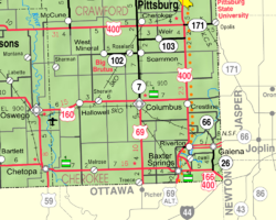
Hallowell, Kansas

Last updated

Hallowell, Kansas
Map of Cherokee Co, Ks, USA.png
USA Kansas location map.svg
Red pog.svg
Hallowell
Usa edcp location map.svg
Red pog.svg
Hallowell
Coordinates: 37°10′25″N94°59′52″W / 37.17361°N 94.99778°W / 37.17361; -94.99778 [1]
Country United States
State Kansas
County Cherokee
Elevation
[1]
843 ft (257 m)
Population
 (2020) [2]
  Total101
Time zone UTC-6 (CST)
  Summer (DST) UTC-5 (CDT)
Area code 620
FIPS code 20-29550
GNIS ID 2806493 [1]

Hallowell is an unincorporated community in Cherokee County, Kansas, United States. [1] As of the 2020 census, the population of the community and nearby areas was 101. [2]

Contents

History

Hallowell was a station on the St. Louis–San Francisco Railway. [3]

Demographics

Historical population
CensusPop.Note
2020 101
U.S. Decennial Census

For statistical purposes, the United States Census Bureau has defined Hallowell as a census-designated place (CDP).

See also

Related Research Articles

<span class="mw-page-title-main">Labette County, Kansas</span> County in Kansas, United States

Labette County is a county located in Southeast Kansas. Its county seat is Oswego, and its most populous city is Parsons. As of the 2020 census, the county population was 20,184. The county was named after LaBette creek, the second-largest creek in the county, which runs roughly NNW-SSE from near Parsons to Chetopa. The creek in turn was named after French-Canadian fur trapper Pierre LaBette who had moved to the area, living along the Neosho River, and marrying into the Osage tribe in the 1830s and 1840s.

<span class="mw-page-title-main">Crawford County, Kansas</span> County in Kansas, United States

Crawford County is a county located in Southeast Kansas. Its county seat is Girard, and its most populous city is Pittsburg. As of the 2020 census, the county population was 38,972. The county was named in honor of Samuel Crawford, the 3rd governor of Kansas. Pittsburg State University is located in Crawford County.

<span class="mw-page-title-main">Cherokee County, Kansas</span> County in Kansas, United States

Cherokee County is a U.S. county located in Southeast Kansas. Its county seat is Columbus, and its most populous city is Baxter Springs. As of the 2020 census, the county population was 19,362. The county was named for the Cherokee tribe.

<span class="mw-page-title-main">Columbus, Kansas</span> City in Cherokee County, Kansas

Columbus is the second largest city and county seat of Cherokee County, Kansas, United States. As of the 2020 census, the population of the city was 2,929. It is located approximately 15 miles south-southwest of Pittsburg.

<span class="mw-page-title-main">Park Hill, Oklahoma</span> Census-designated place in Oklahoma, United States

Park Hill is an unincorporated community and census-designated place (CDP) in southwestern Cherokee County, Oklahoma, United States. The population was 3,909 at the 2010 census. It lies near Tahlequah, east of the junction of U.S. Route 62 and State Highway 82.

Rocky Ford is a census-designated place (CDP) in Delaware and Cherokee counties, Oklahoma, United States. The population was 61 at the 2010 census.

<span class="mw-page-title-main">Riverton, Kansas</span> Unincorporated community in Cherokee County, Kansas

Riverton is an unincorporated community in Cherokee County, Kansas, United States. As of the 2020 census, the population of the community and nearby areas was 771. It is located at the junction of K-66 and U.S. Route 69 Alternate and U.S. Route 400, near the Spring River. It is one of only three communities in Kansas along former U.S. Route 66.

<span class="mw-page-title-main">Linville, North Carolina</span> Census-designated place in North Carolina, United States

Linville is an unincorporated community and census-designated place (CDP) in Avery County, North Carolina, United States. It was first listed as a CDP in the 2020 census with a population of 283. Centered just south of US 221 and NC 105, the community is known as a summer mountain resort and host of the Grandfather Mountain Highland Games, the largest modern Highland games events in North Carolina.

<span class="mw-page-title-main">Sparrowhawk, Oklahoma</span> Census-designated place in Oklahoma, United States

Sparrowhawk is an unincorporated community and census-designated place (CDP) in Cherokee County, Oklahoma, United States. The population was 191 as of the 2010 census, at which time the CDP was known as Scraper. The older name of the community was given for Captain Archibald Scraper of the 2nd Regiment, Indian Home Guard. Sparrowhawk takes its name from Sparrow Hawk Mountain, which occupies most of the CDP.

<span class="mw-page-title-main">Cherokee City, Arkansas</span> Census-designated place in Arkansas, United States

Cherokee City is an unincorporated census-designated place (CDP) in Benton County, Arkansas, United States. Per the 2020 census, the population was 73. It is the location of Coon Creek Bridge, which is located on Cty Rd. 24 and is listed on the National Register of Historic Places. The community was named for the Cherokee, since the Trail of Tears crossed the landscape when the Cherokee migrated west to Indian territory, now Oklahoma in the late 1830s. The town is within the Northwest Arkansas region, located about 5 miles east of Oklahoma and 4 miles south of the Missouri state line.

<span class="mw-page-title-main">Crestline, Kansas</span> Unincorporated community in Cherokee County, Kansas

Crestline is an unincorporated community in Cherokee County, Kansas, United States. As of the 2020 census, the population of the community and nearby areas was 116. Crestline is located on U.S. Route 400 7.5 miles (12.1 km) east of Columbus. Crestline has a post office with ZIP code 66728.

<span class="mw-page-title-main">Kickapoo Site 1, Kansas</span> Unincorporated community in Brown County, Kansas

Kickapoo Site 1 is a unincorporated community on the Kickapoo Reservation in Brown County, Kansas, United States. As of the 2020 census, the population of the community and nearby areas was 110.

<span class="mw-page-title-main">Kickapoo Site 2, Kansas</span> Unincorporated community in Brown County, Kansas

Kickapoo Site 2 is a unincorporated community on the Kickapoo Reservation in Brown County, Kansas, United States. As of the 2020 census, the population of the community and nearby areas was 27.

<span class="mw-page-title-main">Kickapoo Site 5, Kansas</span> Unincorporated community in Brown County, Kansas

Kickapoo Site 5 is a unincorporated community on the Kickapoo Reservation in Brown County, Kansas, United States. As of the 2020 census, the population of the community and nearby areas was 59.

<span class="mw-page-title-main">Kickapoo Site 6, Kansas</span> Unincorporated community in Brown County, Kansas

Kickapoo Site 6 is a unincorporated community on the Kickapoo Reservation in Brown County, Kansas, United States. As of the 2020 census, the population of the community and nearby areas was 13.

<span class="mw-page-title-main">Kickapoo Site 7, Kansas</span> Unincorporated community in Brown County, Kansas

Kickapoo Site 7 is a unincorporated community on the Kickapoo Reservation in Brown County, Kansas, United States. As of the 2020 census, the population of the community and nearby areas was 104.

<span class="mw-page-title-main">Kickapoo Tribal Center, Kansas</span> Unincorporated community in Brown County, Kansas

Kickapoo Tribal Center is a unincorporated community on the Kickapoo Reservation in Brown County, Kansas, United States. As of the 2020 census, the population of the community and nearby areas was 177, making it the most populous location within the reservation.

<span class="mw-page-title-main">Lowell, Kansas</span> Unincorporated community in Cherokee County, Kansas

Lowell is an unincorporated community in Cherokee County, Kansas, United States. As of the 2020 census, the population of the community and nearby areas was 244.

Lake Cherokee is an unincorporated community and census-designated place (CDP) in Gregg and Rusk counties, Texas, United States. Its population was 2,980 as of the 2020 census. Lake Cherokee is located 12 miles southeast of Gregg and northeastern Rusk counties on Cherokee Bayou. The lake is owned by the Cherokee Water Company to supply water for municipal, industrial, and recreational purposes. It has a capacity of 68,700 acre-feet. The lake impounds Cherokee Bayou. The top of the dam is at the elevation of 295 feet above the average sea level, but it has a max design of 291 feet above the average sea level. Lake Cherokee is located 12 miles southeast of Gregg and northeastern Rusk counties on Cherokee Bayou. The lake is owned by the Cherokee Water Company to supply water for municipal, industrial, and recreational purposes.

Pumpkin Hollow is a census-designated place (CDP) in Cherokee County, Oklahoma, United States, within the Cherokee Nation. It was first listed as a CDP prior to the 2020 census.

References

  1. 1 2 3 4 U.S. Geological Survey Geographic Names Information System: Hallowell, Kansas
  2. 1 2 "Profile of Hallowell, Kansas (CDP) in 2020". United States Census Bureau. Archived from the original on November 9, 2022. Retrieved November 9, 2022.
  3. Blackmar, Frank Wilson (1912). Kansas: A Cyclopedia of State History, Embracing Events, Institutions, Industries, Counties, Cities, Towns, Prominent Persons, Etc. Standard Publishing Company. pp.  802.

Further reading