Grant County is a county located on the northern border of the U.S. state of Oklahoma. As of the 2020 census, the population was 4,169. Its county seat is Medford. Originally designated as part of the Cherokee Outlet, it was named County L in Oklahoma Territory at the time of its opening to non-Indian settlement. A county election renamed it for U.S. President Ulysses S. Grant.

Cherokee County is a U.S. county located in Southeast Kansas. Its county seat is Columbus, and its most populous city is Baxter Springs. As of the 2020 census, the county population was 19,362. The county was named for the Cherokee tribe.

Cherokee is a city in Crawford County, Kansas, United States. As of the 2020 census, the population of the city was 590.
Riverton is an unincorporated community in Cherokee County, Kansas, United States. As of the 2020 census, the population of the community and nearby areas was 771. It is located at the junction of K-66 and U.S. Route 69 Alternate and U.S. Route 400, near the Spring River. It is one of only three communities in Kansas along former U.S. Route 66.
Crestline is an unincorporated community in Cherokee County, Kansas, United States. As of the 2020 census, the population of the community and nearby areas was 116. Crestline is located on U.S. Route 400 7.5 miles (12.1 km) east of Columbus. Crestline has a post office with ZIP code 66728.
Turck is a unincorporated community in Cherokee County, Kansas, United States. Its elevation is 932 feet.
Craft is a small unincorporated community in central Cherokee County, Texas (USA). According to the Handbook of Texas, the community had a population of 21 in 2000. It is located within the Tyler-Jacksonville combined statistical area.
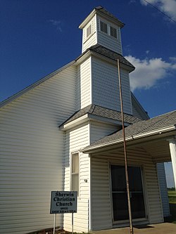
Melrose is an unincorporated community in Neosho Township of Cherokee County, Kansas, United States, and has an elevation of 889 feet (271 m). It contains one church, the Melrose United Methodist Church.
Carona is an unincorporated community in Cherokee County, Kansas, United States.
Lawton is an unincorporated community in Cherokee County, Kansas, United States, and located at 37°13′19″N94°38′10″W.
Empire City is an unincorporated community in Cherokee County, Kansas, United States, and located at 37°05′21″N94°38′31″W.
Neutral is an unincorporated community in Cherokee County, Kansas, United States. It is located approximately five miles northwest of Baxter Springs along the St. Louis and San Francisco Railway. Brush Creek flows past the northeast side of the community and flows into the Spring River near Riverton five miles to the east.
Sherman is an unincorporated community in Cherokee County, Kansas, United States.
Skidmore is an unincorporated community in Cherokee County, Kansas, United States.
Lowell is an unincorporated community in Cherokee County, Kansas, United States. As of the 2020 census, the population of the community and nearby areas was 244.
Cherokee is an unincorporated community in Cherokee County, Kansas, United States. Cokedale is located at 37°14′48″N94°53′34″W.
Keelville is an unincorporated community in Cherokee County, Kansas, United States.
Kniveton is an unincorporated community in Cherokee and Crawford counties of Kansas in the United States.
Stippville is an unincorporated community in Cherokee County, Kansas, United States. It is located 4 miles north of Columbus.