
Clay County is a county located in the far western part of U.S. state North Carolina. As of the 2020 census, the county population was 11,089. The county seat is Hayesville.

Jackson County is a county located in the western part of the U.S. state of North Carolina. As of the 2020 census, the population was 43,109. Since 1913, its county seat has been Sylva, which replaced Webster. Cullowhee is the site of Western Carolina University (WCU). In the early 21st century, the university has more than 12,000 students, nearly twice the number of permanent residents of Cullowhee. The university has a strong influence in the region and county. More than 10 percent of the county residents identify as Native American, mostly Cherokee. The federally recognized Eastern Band of Cherokee Indians is based at Qualla Boundary, land that consists of territory in both Jackson and neighboring Swain County. This is the only federally recognized tribe in North Carolina, and one among three federally recognized Cherokee tribes nationally. The other two are based in what is now the state of Oklahoma, a former Indian Territory.
Sheridan County is a county in the U.S. state of Nebraska. As of the 2020 United States Census, the population was 5,127. Its county seat is Rushville. The county was formed in 1885, and was named for General Philip H. Sheridan.

Sharp County is a county located in the U.S. state of Arkansas. As of the 2020 census, the population was 17,271. The county seat is Ash Flat. The county was formed on July 18, 1868, and named for Ephraim Sharp, a state legislator from the area.

Crawford County is a county located in the Ozarks region of the U.S. state of Arkansas. As of the 2020 census, the population was 60,133. The county seat and largest city is Van Buren. Crawford County was formed on October 18, 1820, from the former Lovely County and Indian Territory, and was named for William H. Crawford, the United States Secretary of War in 1815.
Sheridan Township may refer to:

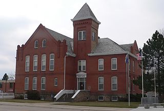
Adams Township is one of nine townships in Hamilton County, Indiana, United States. At the 2010 census, its population was 4,858 and it contained 2,056 housing units.

Cherokee Township is one of sixteen townships in Cherokee County, Iowa, United States. As of the 2000 census, its population was 6,073.

Sheridan Township is one of sixteen townships in Cherokee County, Iowa, United States. As of the 2000 census, its population was 716.

Garden Township is a township in Cherokee County, Kansas, United States. As of the 2000 census, its population was 3,039.

Lola Township is a township in Cherokee County, Kansas, United States. As of the 2000 census, its population was 382.

Lowell Township is a township in Cherokee County, Kansas, United States. As of the 2020 census, its population was 663, down from 675 in 2010.

Neosho Township is a township in Cherokee County, Kansas, United States. As of the 2000 census, its population was 306.

Pleasant View Township is a township in Cherokee County, Kansas, United States. As of the 2000 census, its population was 658.

Shawnee Township is a township in Cherokee County, Kansas, United States. As of the 2000 census, its population was 505.

Spring Valley Township is a township in Cherokee County, Kansas, United States. As of the 2000 census, its population was 1,007.

Sheridan Township is a township in Cowley County, Kansas, USA. As of the 2000 census, its population was 159.

Sheridan Township is a township in Crawford County, Kansas, USA. As of the 2010 census, its population was 1,451.
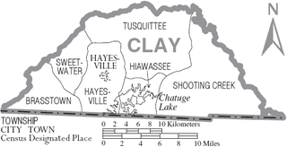
Tusquittee Township is one of the six townships of Clay County, North Carolina, United States and is the northernmost of the six. The other five are Brasstown; Hayesville, which contains the county seat of the same name; Sweetwater, Hiawassee, and Shooting Creek. The name is derived from the Cherokee people, who occupied this area as part of their homeland.
Mary Hill is an unincorporated community in Rock and Sheridan townships, Cherokee County, Iowa, United States. Mary Hill is located along County Highway L48, 7 miles (11 km) west of Cherokee.

