Riverton, Kansas | |
|---|---|
 | |
 Riverton  Riverton | |
| Coordinates: 37°04′24″N94°42′22″W / 37.07333°N 94.70611°W [1] | |
| Country | United States |
| State | Kansas |
| County | Cherokee |
| Area | |
• Total | 2.30 sq mi (5.95 km2) |
| • Land | 2.24 sq mi (5.81 km2) |
| • Water | 0.05 sq mi (0.14 km2) |
| Elevation | 827 ft (252 m) |
| Population | |
• Total | 771 |
| • Density | 340/sq mi (130/km2) |
| Time zone | UTC-6 (CST) |
| • Summer (DST) | UTC-5 (CDT) |
| ZIP code | 66770 [3] |
| Area code | 620 |
| FIPS code | 20-60200 |
| GNIS ID | 2629169 [1] |
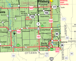
Riverton is a census-designated place (CDP) in Cherokee County, Kansas, United States. [1] As of the 2020 census, the population was 771. [2] It is located at the junction of K-66 (former U.S. Route 66) and U.S. Route 69 Alternate and U.S. Route 400, near the Spring River. It is one of only three communities in Kansas along former U.S. Route 66.


