Lowell, Kansas

Last updated

Lowell, Kansas
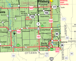
Map of Cherokee Co, Ks, USA.png
USA Kansas location map.svg
Red pog.svg
Lowell
Usa edcp location map.svg
Red pog.svg
Lowell
Coordinates: 37°03′03″N94°42′11″W / 37.05083°N 94.70306°W / 37.05083; -94.70306 [1]
Country United States
State Kansas
County Cherokee
Elevation
[1]
827 ft (252 m)
Population
 (2020) [2]
  Total244
Time zone UTC-6 (CST)
  Summer (DST) UTC-5 (CDT)
ZIP code
66713, 66739
Area code 620
FIPS code 20-43050
GNIS ID 2630053 [1]

Lowell is an unincorporated community in Cherokee County, Kansas, United States. [1] As of the 2020 census, the population of the community and nearby areas was 244. [2]

Contents

History

A post office was opened in Lowell in 1868, and remained in operation until it was discontinued in 1905. [3]

Geography

Lowell is located in southeastern Cherokee County near the southeastern corner of Kansas. It is bordered to the north by the Spring River, a tributary of the Neosho River. Across the river is the community of Riverton. Baxter Springs is 4 miles (6 km) by road to the southwest.

Demographics

Historical population
CensusPop.Note
2010 283
2020 244−13.8%
U.S. Decennial Census

For statistical purposes, the United States Census Bureau has defined Lowell as a census-designated place (CDP).

Related Research Articles

<span class="mw-page-title-main">Cherokee County, Kansas</span> County in Kansas, United States

Cherokee County is a U.S. county located in Southeast Kansas. Its county seat is Columbus, and its most populous city is Baxter Springs. As of the 2020 census, the county population was 19,362. The county was named for the Cherokee tribe.

<span class="mw-page-title-main">Adelphi, Maryland</span> Census-designated place in Maryland

Adelphi is an unincorporated area and census-designated place in Prince George's County, Maryland, United States. Per the 2020 Census, the population was 16,823. Adelphi includes the following subdivisions; Adelphi, Adelphi Park, Adelphi Hills, Adelphi Terrace, Adelphi Village, Buck Lodge, Chatham, Cool Spring Terrace, Hillandale Forest, Holly Hill Manor, Knollwood, Lewisdale, and White Oak Manor.

<span class="mw-page-title-main">Cullowhee, North Carolina</span> Census-designated place in North Carolina, United States

Cullowhee is a census-designated place (CDP) in Jackson County, North Carolina, United States. It is located on the Tuckasegee River, and the permanent population was 7,682 at the 2020 census up from 6,228 at the 2010 census.

<span class="mw-page-title-main">Dry Creek, Oklahoma</span> Census-designated place in Oklahoma, United States

Dry Creek is an unincorporated community and census-designated place (CDP) in Cherokee County, Oklahoma, United States. The population was 227 at the 2010 census.

<span class="mw-page-title-main">Park Hill, Oklahoma</span> Census-designated place in Oklahoma, United States

Park Hill is an unincorporated community and census-designated place (CDP) in southwestern Cherokee County, Oklahoma, United States. The population was 3,909 at the 2010 census. It lies near Tahlequah, east of the junction of U.S. Route 62 and State Highway 82.

<span class="mw-page-title-main">Riverton, Kansas</span> Unincorporated community in Cherokee County, Kansas

Riverton is an unincorporated community in Cherokee County, Kansas, United States. As of the 2020 census, the population of the community and nearby areas was 771. It is located at the junction of K-66 and U.S. Route 69 Alternate and U.S. Route 400, near the Spring River. It is one of only three communities in Kansas along former U.S. Route 66.

<span class="mw-page-title-main">Linville, North Carolina</span> Census-designated place in North Carolina, United States

Linville is an unincorporated community and census-designated place (CDP) in Avery County, North Carolina, United States. It was first listed as a CDP in the 2020 census with a population of 283. Centered just south of US 221 and NC 105, the community is known as a summer mountain resort and host of the Grandfather Mountain Highland Games, the largest modern Highland games events in North Carolina.

<span class="mw-page-title-main">Sparrowhawk, Oklahoma</span> Census-designated place in Oklahoma, United States

Sparrowhawk is an unincorporated community and census-designated place (CDP) in Cherokee County, Oklahoma, United States. The population was 191 as of the 2010 census, at which time the CDP was known as Scraper. The older name of the community was given for Captain Archibald Scraper of the 2nd Regiment, Indian Home Guard. Sparrowhawk takes its name from Sparrow Hawk Mountain, which occupies most of the CDP.

<span class="mw-page-title-main">Grantville, Kansas</span> Unincorporated community in Kansas, United States

Grantville is an unincorporated community in Jefferson County, Kansas, United States. As of the 2020 census, the population of the community and nearby areas was 182. It is located east of Topeka on the south side of US-24 highway between Barton Rd and KOA/Wilson Rd.

<span class="mw-page-title-main">Piney, Oklahoma</span> Census-designated place in Oklahoma, United States

Piney is a census-designated place (CDP) in Adair County, Oklahoma, United States. The population was 115 at the 2010 census. Piney was the "head town" of the first wave of relocated Cherokee people who relocated there from their ancestral homelands in the southeastern United States.

<span class="mw-page-title-main">Bucyrus, Kansas</span> Unincorporated community in Kansas, United States

Bucyrus is an unincorporated community in Miami County, Kansas, United States. As of the 2020 census, the population of the community and nearby areas was 171. It is located 6 miles (9.7 km) east-southeast of Spring Hill, and named after Bucyrus, Ohio. It is part of the Kansas City metropolitan area.

<span class="mw-page-title-main">Crestline, Kansas</span> Unincorporated community in Cherokee County, Kansas

Crestline is an unincorporated community in Cherokee County, Kansas, United States. As of the 2020 census, the population of the community and nearby areas was 116. Crestline is located on U.S. Route 400 7.5 miles (12.1 km) east of Columbus. Crestline has a post office with ZIP code 66728.

<span class="mw-page-title-main">Weskan, Kansas</span> Unincorporated community in Wallace County, Kansas

Weskan is an unincorporated community in Wallace County, Kansas, United States. As of the 2020 census, the population of the community and nearby areas was 158. It is located along U.S. Route 40, 11.5 miles (18.5 km) west-southwest of Sharon Springs. It is the closest community to Mount Sunflower, the highest point in Kanas.

<span class="mw-page-title-main">Hallowell, Kansas</span> Unincorporated community in Cherokee County, Kansas

Hallowell is an unincorporated community in Cherokee County, Kansas, United States. As of the 2020 census, the population of the community and nearby areas was 101.

<span class="mw-page-title-main">Kickapoo Tribal Center, Kansas</span> Unincorporated community in Brown County, Kansas

Kickapoo Tribal Center is a unincorporated community on the Kickapoo Reservation in Brown County, Kansas, United States. As of the 2020 census, the population of the community and nearby areas was 177, making it the most populous location within the reservation.

<span class="mw-page-title-main">Croweburg, Kansas</span> Unincorporated community in Crawford County, Kansas

Croweburg is an unincorporated community in Crawford County, Kansas, United States. As of the 2020 census, the population of the community and nearby areas was 92.

<span class="mw-page-title-main">New Salem, Kansas</span> Unincorporated community in Cowley County, Kansas

New Salem is an unincorporated community in Cowley County, Kansas, United States. As of the 2020 census, the population of the community and nearby areas was 58.

Teresita is an unincorporated community and census-designated place (CDP) in Cherokee County, Oklahoma, United States. The population was 159 at the 2010 census.

Caney Ridge is an unincorporated community and census-designated place (CDP) in Cherokee County, Oklahoma, United States, within the Cherokee Nation. It was first listed as a CDP prior to the 2020 census.

Little Rock is an unincorporated community and census-designated place (CDP) in Mayes County, Oklahoma, United States. It was first listed as a CDP prior to the 2020 census.

References

  1. 1 2 3 4 U.S. Geological Survey Geographic Names Information System: Lowell, Kansas
  2. 1 2 "Profile of Lowell, Kansas (CDP) in 2020". United States Census Bureau. Archived from the original on November 9, 2022. Retrieved November 9, 2022.
  3. "Kansas Post Offices, 1828-1961 (archived)". Kansas Historical Society. Archived from the original on October 9, 2013. Retrieved June 6, 2014.

Further reading