Crawford County is a county located in Southeast Kansas. Its county seat is Girard, and its most populous city is Pittsburg. As of the 2020 census, the county population was 38,972. The county was named in honor of Samuel Crawford, the 3rd governor of Kansas. Pittsburg State University is located in Crawford County.

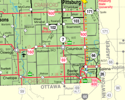
Cherokee County is a U.S. county located in Southeast Kansas. Its county seat is Columbus, and its most populous city is Baxter Springs. As of the 2020 census, the county population was 19,362. The county was named for the Cherokee tribe.

Cherokee is a city in Crawford County, Kansas, United States. As of the 2020 census, the population of the city was 590.
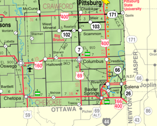
Riverton is an unincorporated community in Cherokee County, Kansas, United States. As of the 2020 census, the population of the community and nearby areas was 771. It is located at the junction of K-66 and U.S. Route 69 Alternate and U.S. Route 400, near the Spring River. It is one of only three communities in Kansas along former U.S. Route 66.

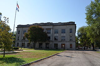
This is a list of the National Register of Historic Places listings in Cherokee County, Kansas.
Crestline is an unincorporated community in Cherokee County, Kansas, United States. As of the 2020 census, the population of the community and nearby areas was 116. Crestline is located on U.S. Route 400 7.5 miles (12.1 km) east of Columbus. Crestline has a post office with ZIP code 66728.
Melrose is an unincorporated community in Neosho Township of Cherokee County, Kansas, United States, and has an elevation of 889 feet (271 m). It contains one church, the Melrose United Methodist Church.
Carona is an unincorporated community in Cherokee County, Kansas, United States.
Lawton is an unincorporated community in Cherokee County, Kansas, United States, and located at 37°13′19″N94°38′10″W.
Empire City is an unincorporated community in Cherokee County, Kansas, United States, and located at 37°05′21″N94°38′31″W.
Neutral is an unincorporated community in Cherokee County, Kansas, United States. It is located approximately five miles northwest of Baxter Springs along the St. Louis and San Francisco Railway. Brush Creek flows past the northeast side of the community and flows into the Spring River near Riverton five miles to the east.
Sherman is an unincorporated community in Cherokee County, Kansas, United States.

Sherwin is an unincorporated community in Cherokee County, Kansas, United States.
Skidmore is an unincorporated community in Cherokee County, Kansas, United States.
Lowell is an unincorporated community in Cherokee County, Kansas, United States. As of the 2020 census, the population of the community and nearby areas was 244.
Cherokee is an unincorporated community in Cherokee County, Kansas, United States. Cokedale is located at 37°14′48″N94°53′34″W.
Keelville is an unincorporated community in Cherokee County, Kansas, United States.
Kniveton is an unincorporated community in Cherokee and Crawford counties of Kansas in the United States.
Stippville is an unincorporated community in Cherokee County, Kansas, United States. It is located 4 miles north of Columbus.