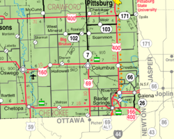
Scammon, Kansas | |
---|---|
Coordinates: 37°16′41″N94°49′23″W / 37.27806°N 94.82306°W [1] | |
Country | United States |
State | Kansas |
County | Cherokee |
Founded | 1884 |
Platted | 1884 |
Incorporated | 1888 |
Named for | Scammon brothers |
Government | |
• Mayor | Jerry Grant [ citation needed ] |
Area | |
• Total | 0.63 sq mi (1.63 km2) |
• Land | 0.63 sq mi (1.62 km2) |
• Water | 0.00 sq mi (0.01 km2) |
Elevation | 906 ft (276 m) |
Population | |
• Total | 376 |
• Density | 600/sq mi (230/km2) |
Time zone | UTC-6 (CST) |
• Summer (DST) | UTC-5 (CDT) |
ZIP code | 66773 |
Area code | 620 |
FIPS code | 20-63325 |
GNIS ID | 485650 [1] |
Website | City website |
Scammon is a city in Cherokee County, Kansas, United States. [1] As of the 2020 census, the population of the city was 376. [3]
Scammon was laid out in 1884. [4] It was named for the four Scammon brothers, who operated the first mine there. [5] David Mackie (1836–1910) was a founder and builder of Scammon, and the first President of the Scammon State Bank. [6] The community was known as Stilson when it was first settled. The town was known as Scammonville for a short time before adopting the current name. [7]
The first post office at Scammonville, established in 1879, was renamed Scammon in 1890. [8]
The local railroad history group Heart of the Heartlands, based in Scammon and nearby unincorporated Carona, has restored the old Carona depot as a museum. [9]
According to the United States Census Bureau, the city has a total area of 0.64 square miles (1.66 km2), all of it land. [10]
Census | Pop. | Note | %± |
---|---|---|---|
1890 | 748 | — | |
1900 | 1,549 | 107.1% | |
1910 | 2,233 | 44.2% | |
1920 | 1,694 | −24.1% | |
1930 | 1,093 | −35.5% | |
1940 | 737 | −32.6% | |
1950 | 561 | −23.9% | |
1960 | 429 | −23.5% | |
1970 | 457 | 6.5% | |
1980 | 501 | 9.6% | |
1990 | 466 | −7.0% | |
2000 | 496 | 6.4% | |
2010 | 482 | −2.8% | |
2020 | 376 | −22.0% | |
U.S. Decennial Census |
As of the census [11] of 2010, there were 482 people, 192 households, and 128 families living in the city. The population density was 753.1 inhabitants per square mile (290.8/km2). There were 219 housing units at an average density of 342.2 per square mile (132.1/km2). The racial makeup of the city was 94.8% White, 0.8% Native American, 0.8% Asian, 1.0% from other races, and 2.5% from two or more races. Hispanic or Latino of any race were 1.5% of the population.
There were 192 households, of which 37.5% had children under the age of 18 living with them, 51.6% were married couples living together, 11.5% had a female householder with no husband present, 3.6% had a male householder with no wife present, and 33.3% were non-families. 26.6% of all households were made up of individuals, and 8.8% had someone living alone who was 65 years of age or older. The average household size was 2.51 and the average family size was 3.09.
The median age in the city was 39.6 years. 27.2% of residents were under the age of 18; 8.6% were between the ages of 18 and 24; 23.6% were from 25 to 44; 27.5% were from 45 to 64; and 12.9% were 65 years of age or older. The gender makeup of the city was 48.8% male and 51.2% female.
As of the census [12] of 2000, there were 496 people, 192 households, and 139 families living in the city. The population density was 782.4 inhabitants per square mile (302.1/km2). There were 222 housing units at an average density of 350.2 per square mile (135.2/km2). The racial makeup of the city was 93.75% White, 0.60% African American, 2.42% Native American, 0.60% Asian, and 2.62% from two or more races. Hispanic or Latino of any race were 0.60% of the population.
There were 192 households, out of which 36.5% had children under the age of 18 living with them, 55.2% were married couples living together, 15.1% had a female householder with no husband present, and 27.6% were non-families. 26.6% of all households were made up of individuals, and 12.0% had someone living alone who was 65 years of age or older. The average household size was 2.58 and the average family size was 3.12.
In the city, the population was spread out, with 29.0% under the age of 18, 8.7% from 18 to 24, 29.4% from 25 to 44, 19.4% from 45 to 64, and 13.5% who were 65 years of age or older. The median age was 34 years. For every 100 females, there were 98.4 males. For every 100 females age 18 and over, there were 85.3 males.
The median income for a household in the city was $35,268, and the median income for a family was $37,708. Males had a median income of $29,219 versus $21,477 for females. The per capita income for the city was $15,926. About 11.3% of families and 12.8% of the population were below the poverty line, including 27.8% of those under age 18 and 4.1% of those age 65 or over.
Cherokee County is a U.S. county located in Southeast Kansas. Its county seat is Columbus, and its most populous city is Baxter Springs. As of the 2020 census, the county population was 19,362. The county was named for the Cherokee tribe.
Scammon Bay is a city in Kusilvak Census Area, Alaska, United States. At the 2010 census the population was 474, up from 465 in 2000.
Colony is a city in Anderson County, Kansas, United States. As of the 2020 census, the population of the city was 381.
Kiowa is a city in Barber County, Kansas, United States. As of the 2020 census, the population of the city was 902. It is located 1 mile north of the Kansas / Oklahoma state border.
Bird City is a city in Cheyenne County, Kansas, United States. As of the 2020 census, the population of the city was 437.
Morganville is a city in Clay County, Kansas, United States. As of the 2020 census, the population of the city was 180.
Cherokee is a city in Crawford County, Kansas, United States. As of the 2020 census, the population of the city was 590.
Richmond is a city in Franklin County, Kansas, United States. As of the 2020 census, the population of the city was 459.
Wellsville is a city in Franklin County, Kansas, United States. As of the 2020 census, the population of the city was 1,953.
Williamsburg is a city in Franklin County, Kansas, United States. As of the 2020 census, the population of the city was 390.
Nashville is a city in Kingman County, Kansas, United States. As of the 2020 census, the population of the city was 54.
Waterville is a city in Marshall County, Kansas, United States. As of the 2020 census, the population of the city was 658.
Ness City is a city in and the county seat of Ness County, Kansas, United States. As of the 2020 census, the population of the city was 1,329. Ness City is famous for its four-story Old Ness County Bank Building located downtown and nicknamed Skyscraper of the Plains.
Lyndon is a city in, and the county seat of Osage County, Kansas, United States. As of the 2020 census, the population of the city was 1,037.
Olsburg is a city in Pottawatomie County, Kansas, United States. As of the 2020 census, the population of the city was 218.
Agenda is a city in Republic County, Kansas, United States. As of the 2020 census, the population of the city was 47.
Viola is a city in Sedgwick County, Kansas, United States. As of the 2020 census, the population of the city was 115.
Mayfield is a city in Sumner County, Kansas, United States. As of the 2020 census, the population of the city was 75.
Clifton is a city in Clay and Washington counties in the U.S. state of Kansas. As of the 2020 census, the population of the city was 454.
Osborn is a city in northern Clinton and southern DeKalb counties in the U.S. state of Missouri. The population was 374 at the 2020 census.