
Jackson County is a county located in the western part of the U.S. state of North Carolina. As of the 2020 census, the population was 43,109. Since 1913, its county seat has been Sylva, which replaced Webster. Cullowhee is the site of Western Carolina University (WCU). In the early 21st century, the university has more than 12,000 students, nearly twice the number of permanent residents of Cullowhee. The university has a strong influence in the region and county. More than 10 percent of the county residents identify as Native American, mostly Cherokee. The federally recognized Eastern Band of Cherokee Indians is based at Qualla Boundary, land that consists of territory in both Jackson and neighboring Swain County. This is the only federally recognized tribe in North Carolina, and one among three federally recognized Cherokee tribes nationally. The other two are based in what is now the state of Oklahoma, a former Indian Territory.

Cherokee County is a U.S. county located in Southeast Kansas. Its county seat is Columbus, and its most populous city is Baxter Springs. As of the 2020 census, the county population was 19,362. The county was named for the Cherokee tribe.
Chatata, meaning "clear water", is the original Cherokee name of an area located in Bradley County, Tennessee. Today the name survives in references to a number of locations in Bradley County, most notably Chatata Valley in the northeastern part of the county. Chatata was also the original name of an unincorporated community in this region now known as Tasso.

U.S. Route 66, the historic east–west US highway between Chicago, Illinois and Santa Monica, California, passed through one brief segment in the southeastern corner of Kansas. It entered the state south of Baxter Springs and continued north until it crossed Brush Creek, from where it turned east and left the state in Galena. After the decertification of the highway in 1985, this road segment was numbered as US-69 (alternate) from Quapaw, Oklahoma north to Riverton, Kansas and as K-66 from Riverton east to Route 66 in Missouri.

Penns Valley is an eroded anticlinal valley of the Pennsylvania ridge and valley geologic region of the Appalachian Mountain range. The valley is located in southern Centre County, Pennsylvania. Along with the Nittany Valley to the north and east, it is part of the larger Nittany Anticlinorium. It is bordered by Mount Nittany to the north, the Seven Mountains range to the south, and connects to the larger Nittany Valley to the west. There are two smaller subordinate valleys typically associated with the greater valley: Georges Valley in the south, separated by Egg Hill, and Brush Valley in the north, separated by Brush Mountain.

The Rainbow Bridge is an old bridge over Brush Creek approximately two miles west of Riverton, Kansas on former U.S. Route 66 (US-66), now a county road. The bridge is a single-span concrete Marsh arch bridge and is the sole surviving bridge of this type on the entire length of the former highway. Two other Marsh arch bridges were also located on US-66 in Kansas, both over the Spring River. It was built in 1923.

The Oconaluftee is the valley of the Oconaluftee River in the Great Smoky Mountains of North Carolina. Formerly the site of a Cherokee village and an Appalachian community, the valley is now North Carolina's main entrance to Great Smoky Mountains National Park.

Madison Township is one of ten townships in Jefferson County, Indiana, United States. As of the 2020 census, its population was 18,007 and it contained 8,264 housing units.
Nineveh Township is one of ten townships in Adair County, Missouri, United States. As of the 2010 census, its population was 1,289. The township is named from the town of Nineveh, a German communistic colony that was established in the area in about 1850.
Adair Township is one of eleven townships in Camden County, Missouri, US. At the 2010 census, its population was 5,062.

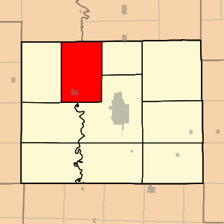
Garden Township is a township in Cherokee County, Kansas, United States. As of the 2000 census, its population was 3,039.

Lola Township is a township in Cherokee County, Kansas, United States. As of the 2000 census, its population was 382.

Lowell Township is a township in Cherokee County, Kansas, United States. As of the 2020 census, its population was 663, down from 675 in 2010.

Pleasant View Township is a township in Cherokee County, Kansas, United States. As of the 2000 census, its population was 658.

Sheridan Township is a township in Crawford County, Kansas, USA. As of the 2010 census, its population was 1,451.

Brush Creek Township is one of 37 townships in Washington County, Arkansas, USA. As of the 2010 census, its unincorporated population was 2,877.
Spring Valley is an unincorporated community in Brush Creek Township, Washington County, Arkansas, United States.

Goshen Township is one of thirty-seven townships in Washington County, Arkansas. As of the 2000 census, its total population was 1,656. The township contains the Town of Goshen and some surrounding unincorporated areas. Goshen Township was established in 1878.
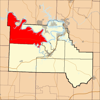
Neutral is an unincorporated community in Cherokee County, Kansas, United States. It is located approximately five miles northwest of Baxter Springs along the St. Louis and San Francisco Railway. Brush Creek flows past the northeast side of the community and flows into the Spring River near Riverton five miles to the east.

