
Hardwick is a town in Worcester County, Massachusetts, United States, about 20 miles (32 km) west of the city of Worcester. It had a population of 2,667 at the 2020 census. It includes the villages of Hardwick, Gilbertville, Wheelwright and Old Furnace.
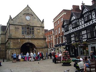
A market town is a settlement most common in Europe that obtained by custom or royal charter, in the Middle Ages, a market right, which allowed it to host a regular market; this distinguished it from a village or city. In Britain, small rural towns with a hinterland of villages are still commonly called market towns, as sometimes reflected in their names.

Sedgefield is a market town and civil parish in County Durham, England. It had a population of 5,211 as at the 2011 census. It has the only operating racecourse in County Durham.
Dana was a town located in Worcester County, Massachusetts. Dana was lost as a result of the formation of the Quabbin Reservoir.

Stokesley is a market town and civil parish in North Yorkshire, England. It lies within the historic county boundaries of the North Riding of Yorkshire, on the River Leven. An electoral ward, of the same name, stretches north to Newby and had a population at the 2011 Census of 5,537.

This is a list of properties and districts in Massachusetts listed on the National Register of Historic Places. There are over 4,300 listings in the state, representing about 5% of all NRHP listings nationwide and the second-most of any U.S. state, behind only New York. Listings appear in all 14 Massachusetts counties.
Linwood is a village with its own post office in the towns of Northbridge and Uxbridge, Massachusetts.
Ironstone is an historic village,, in the township of Uxbridge, Massachusetts, United States. It derived its name from plentiful bog iron found here which helped Uxbridge to become a center for three iron forges in the town's earliest settlement. South Uxbridge has historic sites, picturesque weddings, hospitality, industrial and distribution centers, and the new Uxbridge High School. This community borders North Smithfield, and Burrillville, Rhode Island, and Millville, Massachusetts. South Uxbridge receives municipal services from Uxbridge, for fire, police, EMS, School district, public works, and other services. There is a South Uxbridge fire station of the Uxbridge fire department. Worcester's Judicial District includes Uxbridge District Court. Ironstone appears on the Blackstone U.S. Geological Survey Map. Worcester County is in the Eastern time zone and observes DST.

Ware–Hardwick Covered Bridge is a historic covered bridge spanning the Ware River on Old Gilbertville Road and Bridge Street in Ware and Hardwick, Massachusetts. It is one of a small number of surviving 19th-century covered bridges in the state. The bridge was built in 1886, extensively rebuilt in 1986–1987, and was closed in 2002 due to structural issues and a limited carrying capacity. The bridge reopened in October 2010 and no longer has a weight limit according to MassDOT. It was listed on the National Register of Historic Places in 1986.

The Taunton Green Historic District encompasses the core area of the historic 19th-century commercial downtown business district of Taunton, Massachusetts. It is centered on the town green, laid out in the 1740s, and now stands at the intersection of U.S. Route 44 and State routes 140 and 138. The district was listed on the National Register of Historic Places in 1985.
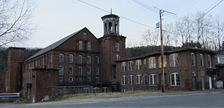
Gilbertville Historic District is a historic district roughly on Main, Church, High, North, Broad and Bridge Streets Gilbertville, Massachusetts within Hardwick, Massachusetts. The district was added to the National Register of Historic Places in 1991. The nearby Ware-Hardwick Covered Bridge is also on the National Register of Historic Places.

11 Beach Street in Reading, Massachusetts is a modest Queen Anne cottage, built c. 1875-1889 based on a published design. Its first documented owner was Emily Ruggles, a prominent local businesswoman and real estate developer. The house was listed on the National Register of Historic Places in 1984.

The Draper Ruggles House is a historic house at 21 Catharine Street in Worcester, Massachusetts. Built about 1848, it is an important local example of Greek Revival architecture. It is further notable as the home of Draper Ruggles, owner of one of the city's major industrial firms, a plow manufacturer. The house was listed on the National Register of Historic Places in 1980.

Flanley's Block is a historic commercial building at 349–353 Main Street in Wakefield, Massachusetts, US. Built about 1895, it is a well-preserved local example of late 19th-century Italianate commercial architecture. The building was listed on the National Register of Historic Places in 1989.

Wakefield Park Historic District is a residential historic district encompassing a portion of a late-19th/early-20th century planned development in western Wakefield, Massachusetts. The district encompasses sixteen properties on 8 acres (3.2 ha) of land out of the approximately 100 acres (40 ha) that comprised the original development. Most of the properties in the district are on Park Avenue, with a few located on immediately adjacent streets.

The Hardwick House is a historic house at 59–61 Spear Street in Quincy, Massachusetts. The 2+1⁄2-story wood-frame house was built in 1850s, and is one of the city's largest Greek Revival houses. Its massing, with side-gable roof, is more typical of the Federal period, but it has corner pilasters, a full entablature, and pedimented gables. The main entry has full-length side lights and is topped by an entablature. The house was built by Franklin Hardwick, owner of a local granite business.

The West Main Street Historic District of Westborough, Massachusetts is an expansive historic district that encompasses a large residential portion of the historic center of the town, as well as part of its commercial center.

The Downtown Hardwick Village Historic District encompasses a significant portion of the downtown area of Hardwick, Vermont. The town developed in the 19th century first as a small industrial center, and later became one of the world's leading processors of granite. The district was listed on the National Register of Historic Places in 1982.

The Hardwick Street Historic District encompasses the earliest settlement area of Hardwick, Vermont. Extending along Hardwick Street and Bayley-Hazen Road in a rural area of eastern Hardwick, it includes eight farm properties dating to the early 19th century. It was listed on the National Register of Historic Places in 1979.


