Harrell, Arkansas

Last updated

Harrell, Arkansas
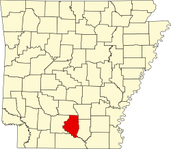
Calhoun County Arkansas Incorporated and Unincorporated areas Harrell Highlighted 0530310.svg
Location of Harrell in Calhoun County, Arkansas.
Coordinates: 33°30′36″N92°24′00″W / 33.51000°N 92.40000°W / 33.51000; -92.40000
Country United States
State Arkansas
County Calhoun
Named for Jedediah Harrell
Area
[1]
  Total0.55 sq mi (1.43 km2)
  Land0.55 sq mi (1.43 km2)
  Water0.00 sq mi (0.00 km2)
Elevation
[2]
203 ft (62 m)
Population
 (2020)
  Total210
  Density380.43/sq mi (147.00/km2)
Time zone UTC-6 (Central (CST))
  Summer (DST) UTC-5 (CDT)
ZIP code
71745
Area code 870
FIPS code 05-30310
GNIS feature ID2406646 [2]

Harrell is a town [3] in Calhoun County, Arkansas, United States. The population was 254 at the 2010 census. It is part of the Camden Micropolitan Statistical Area.

Contents

Geography

According to the United States Census Bureau, the city has a total area of 0.6 square miles (1.6 km2), all land.

Demographics

Historical population
CensusPop.Note
1940 273
1950 34225.3%
1960 267−21.9%
1970 2690.7%
1980 30212.3%
1990 258−14.6%
2000 29313.6%
2010 254−13.3%
2020 210−17.3%
U.S. Decennial Census [4]

2020 Census

Harrell town, Arkansas – Racial and ethnic composition
Note: the US Census treats Hispanic/Latino as an ethnic category. This table excludes Latinos from the racial categories and assigns them to a separate category. Hispanics/Latinos may be of any race.
Race / Ethnicity (NH = Non-Hispanic)Pop 2000 [5] Pop 2010 [6] Pop 2020 [7] % 2000% 2010% 2020
White alone (NH)12612912043.00%50.79%57.14%
Black or African American alone (NH)1651238156.31%48.43%38.57%
Native American or Alaska Native alone (NH)0000.00%0.00%0.00%
Asian alone (NH)0000.00%0.00%0.00%
Pacific Islander alone (NH)0000.00%0.00%0.00%
Some Other Race alone (NH)0000.00%0.00%0.00%
Mixed Race or Multi-Racial (NH)2240.68%0.79%1.90%
Hispanic or Latino (any race)0050.00%0.00%2.38%
Total293254210100.00%100.00%100.00%

As of the census [8] of 2000, there were 293 people, 120 households, and 81 families residing in the city. The population density was 472.0 inhabitants per square mile (182.2/km2). There were 139 housing units at an average density of 223.9 per square mile (86.4/km2). The racial makeup of the city was 43.00% White, 56.31% Black or African American, and 0.68% from two or more races.

There were 120 households, out of which 32.5% had children under the age of 18 living with them, 43.3% were married couples living together, 20.8% had a female householder with no husband present, and 32.5% were non-families. 28.3% of all households were made up of individuals, and 13.3% had someone living alone who was 65 years of age or older. The average household size was 2.44 and the average family size was 2.94.

In the city the population was spread out, with 28.3% under the age of 18, 9.2% from 18 to 24, 27.3% from 25 to 44, 19.8% from 45 to 64, and 15.4% who were 65 years of age or older. The median age was 34 years. For every 100 females, there were 83.1 males. For every 100 females age 18 and over, there were 75.0 males.

The median income for a household in the city was $21,875, and the median income for a family was $33,333. Males had a median income of $30,500 versus $14,500 for females. The per capita income for the city was $12,539. About 15.0% of families and 23.5% of the population were below the poverty line, including 25.3% of those under the age of eighteen and 20.0% of those 65 or over.

Education

Public education is available via the Hampton School District based in Hampton, with students graduating from Hampton High School. The school district encompasses 479.67 square miles (1,242.3 km2) of land including all of Hampton and portions of several Calhoun County communities including Camden, Harrell, and Tinsman.

Related Research Articles

<span class="mw-page-title-main">Calhoun County, Alabama</span> County in Alabama, United States

Calhoun County is a county in the east central part of the U.S. state of Alabama. As of the 2020 census, the population was 116,441. Its county seat is Anniston. It is named in honor of John C. Calhoun, a US Senator from South Carolina.

<span class="mw-page-title-main">Cherokee County, Alabama</span> County in Alabama, United States

Cherokee County, Alabama is a county located in the northeastern part of the U.S. state of Alabama. As of the 2020 census, the population was 24,971. Its county seat is Centre. The county is named for the Cherokee tribe.

<span class="mw-page-title-main">Etowah County, Alabama</span> County in Alabama, United States

Etowah County is a county located in the northeastern part of the U.S. state of Alabama. As of the 2020 census the population was 103,436. Its county seat is Gadsden. Its name is from a Cherokee word meaning "edible tree". In total area, it is the smallest county in Alabama, but one of the most densely populated. Etowah County comprises the Gadsden Metropolitan Statistical Area.

<span class="mw-page-title-main">Cleburne County, Alabama</span> County in Alabama, United States

Cleburne County is a county located in the east central portion of the U.S. state of Alabama. As of the 2020 census, the population was 15,056. Its county seat is Heflin. Its name is in honor of Patrick R. Cleburne of Arkansas who rose to the rank of major general in the Confederate States Army. The eastern side of the county borders the state of Georgia.

<span class="mw-page-title-main">Calhoun County, Arkansas</span> County in Arkansas, United States

Calhoun County is a county located in the south central part of the U.S. state of Arkansas. As of the 2020 census, the population was 4,739, making it the least populous county in Arkansas. The county seat is Hampton. Calhoun County is Arkansas's 55th county, formed on December 6, 1850, and named for John C. Calhoun, a Vice President of the United States.

<span class="mw-page-title-main">North Crossett, Arkansas</span> CDP in Arkansas, United States

North Crossett is a census-designated place (CDP) in Ashley County, Arkansas, United States. Per the 2020 census, the population was 2,756.

<span class="mw-page-title-main">West Crossett, Arkansas</span> CDP in Arkansas, United States

West Crossett is a census-designated place (CDP) in Ashley County, Arkansas, United States. Per the 2020 census, the population was 1,144.

<span class="mw-page-title-main">Hampton, Arkansas</span> Town in Arkansas, United States

Hampton is a town in Calhoun County, Arkansas, United States. The population was 1,181 according to the 2020 United States Census. The town is the county seat of Calhoun County.

<span class="mw-page-title-main">Tinsman, Arkansas</span> Town in Arkansas, United States

Tinsman is a town in Calhoun County, Arkansas, United States. The population was 54 at the 2010 census. It is part of the Camden Micropolitan Statistical Area.

<span class="mw-page-title-main">Anthonyville, Arkansas</span> Town in Arkansas, United States

Anthonyville is a town in Crittenden County, Arkansas, United States. The population was 161 at the 2010 census, down from 250 in 2000.

<span class="mw-page-title-main">Edmondson, Arkansas</span> Town in Arkansas, United States

Edmondson is a town in Crittenden County, Arkansas, United States. The population was 427 at the 2010 census.

<span class="mw-page-title-main">Turrell, Arkansas</span> City in Arkansas, United States

Turrell is a city in Crittenden County, Arkansas, United States. Per the 2020 census, the population was 517.

<span class="mw-page-title-main">Carthage, Arkansas</span> Town in Arkansas, United States

Carthage is a town in Dallas County, Arkansas, United States. The population was 343 at the 2010 census.

<span class="mw-page-title-main">Jerome, Arkansas</span> Census designated place in Arkansas, United States

Jerome is an unincorporated community and former town in Drew County, Arkansas, United States. On October 14, 2021, the Jerome City Council elected to surrender the town's charter and officially declared Jerome no longer in existence as an incorporated entity. It is now listed as a census designated place.

<span class="mw-page-title-main">Bradley, Arkansas</span> City in Arkansas, United States

Bradley is a city in Lafayette County, Arkansas, United States. The population was 628 at the 2010 census.

<span class="mw-page-title-main">Bluff City, Arkansas</span> Town in Arkansas, United States

Bluff City is an unincorporated town in Nevada County, Arkansas, United States. The population was 158 at the 2000 census. It is part of the Hope Micropolitan Statistical Area.

<span class="mw-page-title-main">Landmark, Arkansas</span> CDP in Arkansas, United States

Landmark is a census-designated place (CDP) in Pulaski County, Arkansas, United States. Per the 2020 census, the population was 3,585. It is part of the Little Rock–North Little Rock–Conway Metropolitan Statistical Area.

<span class="mw-page-title-main">Salem, Saline County, Arkansas</span> CDP in Arkansas, United States

Salem is a census-designated place (CDP) in Saline County, Arkansas, United States. Per the 2020 census, the population was 2,544. It is part of the Little Rock–North Little Rock–Conway Metropolitan Statistical Area.

<span class="mw-page-title-main">Hughes, Arkansas</span> Town in Arkansas, United States

Hughes is a city in St. Francis County, Arkansas, United States. As of the 2020 census, it had a population of 1,056.

<span class="mw-page-title-main">Bonita, Louisiana</span> Village in Louisiana, United States

Bonita is a village in Morehouse Parish, Louisiana, United States. The population was 170 at the 2020 census, down from 284 in 2010.

References

  1. "2020 U.S. Gazetteer Files". United States Census Bureau. Retrieved October 29, 2021.
  2. 1 2 U.S. Geological Survey Geographic Names Information System: Harrell, Arkansas
  3. Local.Arkansas.gov - Harrell , retrieved September 3, 2012
  4. "Census of Population and Housing". Census.gov. Retrieved June 4, 2015.
  5. "P004 Hispanic or Latino, and Not Hispanic or Latino by Race – 2000: DEC Summary File 1 – Harrell town, Arkansas". United States Census Bureau .
  6. "P2 Hispanic or Latino, and Not Hispanic or Latino by Race – 2010: DEC Redistricting Data (PL 94-171) – Harrell town, Arkansas". United States Census Bureau .
  7. "P2 Hispanic or Latino, and Not Hispanic or Latino by Race – 2020: DEC Redistricting Data (PL 94-171) – Harrell town, Arkansas". United States Census Bureau .
  8. "U.S. Census website". United States Census Bureau . Retrieved January 31, 2008.