The Hawaiian–Emperor seamount chain is a mostly undersea mountain range in the Pacific Ocean that reaches above sea level in Hawaii. It is composed of the Hawaiian ridge, consisting of the islands of the Hawaiian chain northwest to Kure Atoll, and the Emperor Seamounts: together they form a vast underwater mountain region of islands and intervening seamounts, atolls, shallows, banks and reefs along a line trending southeast to northwest beneath the northern Pacific Ocean. The seamount chain, containing over 80 identified undersea volcanoes, stretches about 6,200 km (3,900 mi) from the Aleutian Trench off the coast of the Kamchatka peninsula in the far northwest Pacific to the Kamaʻehuakanaloa Seamount (formerly Lōʻihi), the youngest volcano in the chain, which lies about 35 kilometres (22 mi) southeast of the Island of Hawaiʻi.
The chain can be divided into three subsections. The first, the Hawaiian archipelago (also known as the Windward isles), consists of the islands comprising the U.S. state of Hawaii. As it is the closest to the hotspot, this volcanically active region is the youngest part of the chain, with ages ranging from 400,000 years [1] to 5.1 million years. [2] The island of Hawaiʻi is composed of five volcanoes, of which four (Kilauea, Mauna Loa, Hualalai, and Mauna Kea) are active. The island of Maui has one active volcano, Haleakalā. Kamaʻehuakanaloa Seamount continues to grow offshore of Hawaiʻi island, and is the only known volcano in the chain in the submarine pre-shield stage. [3]
The second part of the chain is composed of the Northwestern Hawaiian Islands, collectively referred to as the Leeward isles, the constituents of which are between 7.2 and 27.7 million years old. [2] Erosion has long since overtaken volcanic activity at these islands, and most of them are atolls, atoll islands, and extinct islands. They contain many of the most northerly atolls in the world; Kure Atoll, in this group, is the northernmost atoll on Earth. [4] On June 15, 2006, U.S. President George W. Bush issued a proclamation creating Papahānaumokuākea Marine National Monument under the Antiquities Act of 1906. The national monument, meant to protect the biodiversity of the Hawaiian isles, [n 1] encompasses all of the northern isles, and is one of the largest such protected areas in the world. The proclamation limits tourism to the area, and called for a phase-out of fishing by 2011. [5]
The oldest and most heavily eroded part of the chain are the Emperor seamounts, which are 39 [6] to 85 million years old. [7] The Emperor and Hawaiian chains form an angle of about 120°. This bend was long attributed to a relatively sudden change of 60° in the direction of plate motion, but research conducted in 2003 suggests that it was the movement of the hotspot itself that caused the bend. [8] The issue continues to remain under academic debate. [9] All of the volcanoes in this part of the chain have long since subsided below sea level, becoming seamounts and guyots. Many of the volcanoes are named after former emperors of Japan. The seamount chain extends to the West Pacific, and terminates at the Kuril–Kamchatka Trench, a subduction zone at the border of Russia. [10]
The oldest confirmed age for one of the Emperor Seamounts is 81 million years, for Detroit Seamount. However, Meiji Seamount, located to the north of Detroit Seamount, is likely somewhat older.
In 1963, geologist John Tuzo Wilson hypothesized the origins of the Hawaiian–Emperor seamount chain, explaining that they were created by a hotspot of volcanic activity that was essentially stationary as the Pacific tectonic plate drifted in a northwesterly direction, leaving a trail of increasingly eroded volcanic islands and seamounts in its wake. An otherwise inexplicable kink in the chain marks a shift in the movement of the Pacific plate some 47 million years ago, from a northward to a more northwesterly direction, and the kink has been presented in geology texts as an example of how a tectonic plate can shift direction comparatively suddenly. A look at the USGS map on the origin of the Hawaiian Islands [11] clearly shows this "spearpoint".
In a more recent study, Sharp and Clague interpret the bend as starting at about 50 million years ago. They also conclude that the bend formed from a "traditional" cause—a change in the direction of motion of the Pacific plate. [12]
However, recent research shows that the hotspot itself may have moved with time. Some evidence comes from analysis of the orientation of the ancient magnetic field preserved by magnetite in ancient lava flows sampled at four seamounts: [13] this evidence from paleomagnetism shows a more complex history than the commonly accepted view of a stationary hotspot. If the hotspot had remained above a fixed mantle plume during the past 80 million years, the latitude as recorded by the orientation of the ancient magnetic field preserved by magnetite (paleolatitude) should be constant for each sample; this should also signify original cooling at the same latitude as the current location of the Hawaiian hotspot. Instead of remaining constant, the paleolatitudes of the Emperor Seamounts show a change from north to south, with decreasing age. The paleomagnetic data from the seamounts of the Emperor chain suggest motion of the Hawaiian hotspot in Earth's mantle. Tarduno et al. have interpreted that the bend in the seamount chain may be caused by circulation patterns in the flowing solid mantle (mantle "wind") rather than a change in plate motion. [14]
There are two distinct interpretations for the cause of the bend in the seamounts of the Emperor chain as previously mentioned. First, that the bend was caused only by a change in the Pacific plate motion. Second, that the bend was caused by hotspot movement only. In 2004 geologist Yaoling Niu proposed a model that attributed the bend largely to a change in plate motion along with some motion in the hotspot. [15] Niu proposes that the bend starts at 43 Ma which is caused by a "trench jam". This "trench jam" is caused by the arrival of the Emperor chain seamounts at the northern subduction zone. These thick, buoyant seamounts resisted subduction and caused a reorientation of plate motion. Thus explains the sudden change in plate motion and is supported by the orientation of nearby island chains which also have a sudden bend which mirror the Emperor chain. As shown by Tarduno et al., [14] the hotspot does show some north-south motion, but Yaoling's model shows that for the bend to be attributed completely to hotspot motion, the pacific plate would have to remain stationary from 81 Ma to 43 Ma. Thus, is not true as magnetic anomalies on the pacific plate indicate motion of around 60 mm per year during that period. This model consisting of a change in plate motion combined with small north-south motions of the hotspot seems to be the best supported theory concerning the bend in the Emperor chain to date.
In addition to previous interpretations of the cause of the bend in the seamount chain, Hu et al. have proposed a close relationship between mantle plume migration and change in plate tectonic motion. Expanding on previous models, it has been interpreted that the Pacific Plate's motion was predominantly in the northern direction prior to 47 million years ago. Traditionally, the force pulling the Pacific Plate to the north was attributed to the Izanagi - Pacific Ridge subduction zone. However, in a 2021 study, Hu et al. proposed that this subduction zone was not a strong enough force to have been pulling the Pacific Plate on its own. [16] Instead, they introduced the concept that there was an intra-oceanic subduction zone involving the Kronotsky and Olyutorsky arcs. According to their findings, this subduction zone played a significant role in northern directional pull on the Pacific Plate. Around 47 million years ago, these northern forces came to an end. Near the same time, there were notable changes in the movement of the Hawaiian hotspot. Approximately 50 Ma, the Hawaiian hotspot started to drift to the south. However, there is not a widely accepted theory as to the mechanism that caused the hotspot to drift. The combination of these events along with new subduction zones in the west, could explain the large bend present in the Hawaiian - Emperor Seamount Chain.
The chain has been produced by the movement of the ocean crust over the Hawaiʻi hotspot, an upwelling of hot rock from the Earth's mantle. As the oceanic crust moves the volcanoes farther away from their source of magma, their eruptions become less frequent and less powerful until they eventually cease altogether. At that point erosion of the volcano and subsidence of the seafloor cause the volcano to gradually diminish. As the volcano sinks and erodes, it first becomes an atoll island and then an atoll. Further subsidence causes the volcano to sink below the sea surface, becoming a seamount and/or a guyot. [3]
From the 1960s to the 1980s, the seamounts were intensively bottom trawled. Trawling has continued since then at lower rates, particularly by Japanese ships seeking Pentaceros wheeleri . The North Pacific Fisheries Commission regulates fishing in the area. [17]
The Samoan archipelago is a chain of 16 islands and numerous seamounts covering 3,123 km2 (1,206 sq mi) in the central South Pacific, south of the equator, about halfway between Hawaii and New Zealand, forming part of Polynesia and of the wider region of Oceania. The islands are Savaiʻi, Upolu, Tutuila, ’Uvea, Taʻū, Ofu, Olosega, Apolima, Manono, Nuʻutele, Niulakita, Nuʻulua, Namua, Fanuatapu, Rose Atoll, Nu'ulopa, as well as the submerged Vailuluʻu, Pasco banks, and Alexa Bank.
A mantle plume is a proposed mechanism of convection within the Earth's mantle, hypothesized to explain anomalous volcanism. Because the plume head partially melts on reaching shallow depths, a plume is often invoked as the cause of volcanic hotspots, such as Hawaii or Iceland, and large igneous provinces such as the Deccan and Siberian Traps. Some such volcanic regions lie far from tectonic plate boundaries, while others represent unusually large-volume volcanism near plate boundaries.
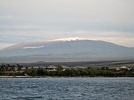
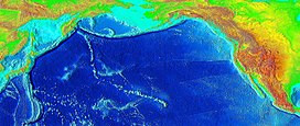
The evolution of Hawaiian volcanoes occurs in several stages of growth and decline. The fifteen volcanoes that make up the eight principal islands of Hawaii are the youngest in a chain of more than 129 volcanoes that stretch 5,800 kilometers (3,600 mi) across the North Pacific Ocean, called the Hawaiian–Emperor seamount chain. Hawaiʻi's volcanoes rise an average of 4,600 meters (15,000 ft) to reach sea level from their base. The largest, Mauna Loa, is 4,169 meters (13,678 ft) high. As shield volcanoes, they are built by accumulated lava flows, growing a few meters or feet at a time to form a broad and gently sloping shape.
In geology, hotspots are volcanic locales thought to be fed by underlying mantle that is anomalously hot compared with the surrounding mantle. Examples include the Hawaii, Iceland, and Yellowstone hotspots. A hotspot's position on the Earth's surface is independent of tectonic plate boundaries, and so hotspots may create a chain of volcanoes as the plates move above them.
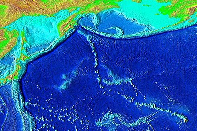
Meiji Seamount, named after Emperor Meiji, the 122nd Emperor of Japan, is the oldest seamount in the Hawaiian-Emperor seamount chain, with an estimated age of 82 million years. It lies at the northernmost end of the chain, lies off the coast of the Kamchatka Peninsula, and is perched at the outer slope of the Kuril–Kamchatka Trench. Like the rest of the Emperor seamounts, it was formed by the Hawaii hotspot volcanism, grew to become an island, and has since subsided to below sea level, all while being carried first north and now northwest by the motion of the Pacific Plate. Meiji Seamount is thus an example of a particular type of seamount known as a guyot, and some publications refer to it as Meiji Guyot.
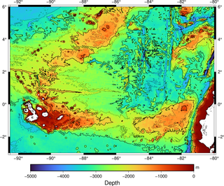
The Galápagos hotspot is a volcanic hotspot in the East Pacific Ocean responsible for the creation of the Galápagos Islands as well as three major aseismic ridge systems, Carnegie, Cocos and Malpelo which are on two tectonic plates. The hotspot is located near the Equator on the Nazca Plate not far from the divergent plate boundary with the Cocos Plate. The tectonic setting of the hotspot is complicated by the Galápagos triple junction of the Nazca and Cocos plates with the Pacific plate. The movement of the plates over the hotspot is determined not solely by the spreading along the ridge but also by the relative motion between the Pacific plate and the Cocos and Nazca plates.
The Hawaiʻi hotspot is a volcanic hotspot located near the namesake Hawaiian Islands, in the northern Pacific Ocean. One of the best known and intensively studied hotspots in the world, the Hawaii plume is responsible for the creation of the Hawaiian–Emperor seamount chain, a 6,200-kilometer (3,900 mi) mostly undersea volcanic mountain range. Four of these volcanoes are active, two are dormant; more than 123 are extinct, most now preserved as atolls or seamounts. The chain extends from south of the island of Hawaiʻi to the edge of the Aleutian Trench, near the eastern coast of Russia.
The Louisville Ridge, often now referred to as the Louisville Seamount Chain, is an underwater chain of over 70 seamounts located in the Southwest portion of the Pacific Ocean. As one of the longest seamount chains on Earth it stretches some 4,300 km (2,700 mi) from the Pacific-Antarctic Ridge northwest to the Tonga-Kermadec Trench, where it subducts under the Indo-Australian Plate as part of the Pacific Plate. The chains formation is best explained by movement of the Pacific Plate over the Louisville hotspot although others had suggested by leakage of magma from the shallow mantle up through the Eltanin fracture zone, which it follows closely for some of its course.
The Louisville hotspot is a volcanic hotspot responsible for the volcanic activity that has formed the Louisville Ridge in the southern Pacific Ocean.
The Osbourn Seamount is a seamount in the south-west Pacific Ocean. It is the westernmost and oldest unsubducted seamount of the Louisville Ridge, with an estimated age of 78.8 ± 1.3 Ma. Like other seamounts comprising the Louisville Ridge, it was formed by the Louisville hotspot which is currently located 4,300 km (2,700 mi) away near the Pacific-Antarctic Ridge.
The Samoa hotspot is a volcanic hotspot located in the south Pacific Ocean. The hotspot model describes a hot upwelling plume of magma through the Earth's crust as an explanation of how volcanic islands are formed. The hotspot idea came from J. Tuzo Wilson in 1963 based on the Hawaiian Islands volcanic chain.
The Macdonald hotspot is a volcanic hotspot in the southern Pacific Ocean. The hotspot was responsible for the formation of the Macdonald Seamount, and possibly the Austral-Cook Islands chain. It probably did not generate all of the volcanism in the Austral and Cook Islands as age data imply that several additional hotspots were needed to generate some volcanoes.
Ocean island basalt (OIB) is a volcanic rock, usually basaltic in composition, erupted in oceans away from tectonic plate boundaries. Although ocean island basaltic magma is mainly erupted as basalt lava, the basaltic magma is sometimes modified by igneous differentiation to produce a range of other volcanic rock types, for example, rhyolite in Iceland, and phonolite and trachyte at the intraplate volcano Fernando de Noronha. Unlike mid-ocean ridge basalts (MORBs), which erupt at spreading centers (divergent plate boundaries), and volcanic arc lavas, which erupt at subduction zones (convergent plate boundaries), ocean island basalts are the result of intraplate volcanism. However, some ocean island basalt locations coincide with plate boundaries like Iceland, which sits on top of a mid-ocean ridge, and Samoa, which is located near a subduction zone.
The Pacific Ocean evolved in the Mesozoic from the Panthalassic Ocean, which had formed when Rodinia rifted apart around 750 Ma. The first ocean floor which is part of the current Pacific plate began 160 Ma to the west of the central Pacific and subsequently developed into the largest oceanic plate on Earth.
Arago hotspot is a hotspot in the Pacific Ocean, presently located below the Arago seamount close to the island of Rurutu, French Polynesia.
Musicians Seamounts are a chain of seamounts in the Pacific Ocean, north of the Hawaiian Ridge. There are about 65 seamounts, some of which are named after musicians. These seamounts exist in two chains, one of which has been attributed to a probably now-extinct hotspot called the Euterpe hotspot. Others may have formed in response to plate tectonics associated with the boundary between the Pacific plate and the former Farallon plate.
The Rarotonga hotspot is a volcanic hotspot in the southern Pacific Ocean. The hotspot is claimed to be responsible for the formation of Rarotonga and some volcanics of Aitutaki but an alternative explanation for these islands most recent volcanics has not been ruled out. Recently alternatives to hotspot activity have been offered for several other intra-plate volcanoes that may have been associated with the Rarotonga hotspot hypothesis.
The plate theory is a model of volcanism that attributes all volcanic activity on Earth, even that which appears superficially to be anomalous, to the operation of plate tectonics. According to the plate theory, the principal cause of volcanism is extension of the lithosphere. Extension of the lithosphere is a function of the lithospheric stress field. The global distribution of volcanic activity at a given time reflects the contemporaneous lithospheric stress field, and changes in the spatial and temporal distribution of volcanoes reflect changes in the stress field. The main factors governing the evolution of the stress field are:
Intraplate volcanism is volcanism that takes place away from the margins of tectonic plates. Most volcanic activity takes place on plate margins, and there is broad consensus among geologists that this activity is explained well by the theory of plate tectonics. However, the origins of volcanic activity within plates remains controversial.
Informational notes
Citations
Further reading