Helsinki is the capital, primate, and most populous city of Finland. Located on the shore of the Gulf of Finland, it is the seat of the region of Uusimaa in southern Finland, and has a population of 658,864. The city's urban area has a population of 1,268,296, making it by far the most populous urban area in Finland as well as the country's most important center for politics, education, finance, culture, and research; while Tampere in the Pirkanmaa region, located 179 kilometres (111 mi) to the north from Helsinki, is the second largest urban area in Finland. Helsinki is located 80 kilometres (50 mi) north of Tallinn, Estonia, 400 km (250 mi) east of Stockholm, Sweden, and 300 km (190 mi) west of Saint Petersburg, Russia. It has close historical ties with these three cities.

Vantaa is a city and municipality in Finland. It is part of the inner core of the Finnish Capital Region along with Helsinki, Espoo, and Kauniainen. With a population of 239,216, Vantaa is the fourth most populated city in Finland after Helsinki, Espoo and Tampere. Its administrative center is the Tikkurila district. Vantaa is bordered by Helsinki, the Finnish capital, to the south; Espoo to the southwest; Nurmijärvi to the northwest; Kerava and Tuusula to the north; and Sipoo to the east. The city encompasses 240.35 square kilometres (92.80 sq mi), of which 1.97 km2 (0.76 sq mi) is water.

Espoo is a city and municipality in the region of Uusimaa in the Republic of Finland. It is located on the northern shore of the Gulf of Finland, bordering the cities of Helsinki, Vantaa, Kirkkonummi, Vihti and Nurmijärvi while surrounding the enclaved town of Kauniainen. The city covers 528.03 square kilometres (203.9 sq mi) with a population of about 300,000 residents in 2022, making it the 2nd-most populous city in Finland. Espoo forms a major part of a substantially larger metropolitan area known as Greater Helsinki, home to over 1.5 million people in 2020.

Kauniainen is a small town and a municipality of 10,401 inhabitants in the Helsinki Metropolitan Area, Finland. It is surrounded and enclaved by the City of Espoo, in the Capital Region of Greater Helsinki. Kauniainen was founded by a corporation in 1906, AB Grankulla, that parcelled land and created a suburb for villas; Kauniainen received the status of a market town in 1920, the Finnish name in 1949 and the title of kaupunki in 1972.

Turku is a city and former capital on the southwest coast of Finland at the mouth of the Aura River, in the region of Finland Proper (Varsinais-Suomi) and the former Turku and Pori Province. The region was originally called Suomi (Finland), which later became the name for the whole country. As of 31 March 2021, the population of Turku was 194,244 making it the sixth largest city in Finland after Helsinki, Espoo, Tampere, Vantaa and Oulu. There were 281,108 inhabitants living in the Turku Central Locality, ranking it as the third largest urban area in Finland after the Capital Region area and Tampere Central Locality. The city is officially bilingual as 5.2 percent of its population identify Swedish as a mother-tongue.

Porvoo is a city and a municipality in the Uusimaa region of Finland, situated on the southern coast about 35 kilometres (22 mi) east of the city border of Helsinki and about 50 kilometres (30 mi) from the city centre. Porvoo was one of the six medieval towns of Finland, along with Turku, Ulvila, Rauma, Naantali and Vyborg. It is first mentioned as a city in texts from the 14th century. Porvoo is the seat of the Swedish-speaking Diocese of Borgå of the Evangelical Lutheran Church of Finland. Porvoo was briefly the capital of the former Eastern Uusimaa region.
Between 1634 and 2009, Finland was administered as several provinces. Finland had always been a unitary state: the provincial authorities were part of the central government's executive branch and apart from Åland, the provinces had little autonomy. There were never any elected provincial parliaments in continental Finland. The system was initially created in 1634. Its makeup was changed drastically on 1 September 1997, when the number of the provinces was reduced from twelve to six. This effectively made them purely administrative units, as linguistic and cultural boundaries no longer followed the borders of the provinces. The provinces were eventually abolished at the end of 2009. Consequently, different ministries may subdivide their areal organization differently. Besides the former provinces, the municipalities of Finland form the fundamental subdivisions of the country. In current use are the regions of Finland, a smaller subdivision where some pre-1997 läänis are split into multiple regions. Åland retains its special autonomous status and its own regional parliament.

The University of Helsinki is a public research university located in Helsinki, Finland since 1829, but founded in the city of Turku in 1640 as the Royal Academy of Åbo, at that time part of the Swedish Empire. It is the oldest and largest university in Finland with the widest range of disciplines available. In 2020, around 31,600 students were enrolled in the degree programs of the university spread across 11 faculties and 11 research institutes.

Vuosaari is a neighbourhood in the City of Helsinki, Finland. It is located by the sea in East Helsinki and with its area of 15.38 km2 (5.94 sq mi) is geographically the largest district in the city. It also has two Helsinki Metro stations, Rastila and Vuosaari

Loviisa is a municipality and town of 14,644 inhabitants on the southern coast of Finland. It is located 90 kilometres (56 mi) from Helsinki and 38 kilometres (24 mi) from Porvoo. About 43 per cent of the population is Swedish-speaking.
Sipoo is a municipality of Finland. It is part of the Helsinki metropolitan area. The municipality has a population of 22,186 (31 December 2021) and covers an area of 698.60 square kilometres (269.73 sq mi) of which 358.97 km2 (138.60 sq mi) is water. The population density is 65.33 inhabitants per square kilometre (169.2/sq mi). The administrative center of the municipality is Nikkilä, which is located 34 kilometres (21 mi) northeast of the center of Helsinki. Another significant urban area is Söderkulla, located in the southern part of the municipality.

Järvenpää is a town and municipality in Finland. It is located on the Helsinki–Riihimäki railway track in Uusimaa region, some 37 kilometres (23 mi) north of Helsinki. Neighbouring municipalities are Tuusula, Sipoo and Mäntsälä. People also refer to Kerava as Järvenpää's neighbour, even though they do not technically share a border, thanks to the one kilometre-wide land area that belongs to Tuusula.

Lauttasaari is an island in Helsinki, Finland, about 3 kilometres (1.9 mi) west of the city centre. Together with some surrounding unpopulated small islands, Lauttasaari is also a district of Helsinki. With 23,226 residents as of 2017, the island is Finland's second largest by population, after Fasta Åland. Its land area is 3.85 km2.

Kamppi is a neighbourhood in the centre of Helsinki, the capital of Finland. The name originally referred to a small area known as the "Kamppi field", but according to the current official designation, "Kamppi" encompasses a much larger area with a population of 10,000 in 2004.
Kallio is a district and a neighbourhood in Helsinki, the capital of Finland, located on the eastern side of the Helsinki peninsula about one kilometre north from the city centre. It is one of the most densely populated areas in Finland. Kallio is separated from the city centre by the Siltasaarensalmi strait, over which is a bridge called Pitkäsilta. Traditionally, the bridge symbolizes the divide between the affluent centre and the more working class areas around Kallio.

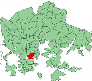
East Helsinki is an area in Helsinki, Finland, usually thought to comprise the city's eastern and south-eastern major districts, including the districts of Vartiokylä, Myllypuro, Mellunkylä, Vuosaari, Herttoniemi, Laajasalo and Kulosaari. With the exception of Kulosaari, the buildings in the area are relatively new – most have been built in the 1960s or later – and constitute relatively densely inhabited suburbs, except for the southern part of Laajasalo and most of Kulosaari. On the other side of the bridge to the west of Kulosaari is Helsinki Downtown, the so-called "South Helsinki". The most important road connection to the city central from East Helsinki with car or bus runs along Itäväylä.

Jätkäsaari is a peninsula and a quarter in Helsinki, the capital city of Finland. It is part to the Kampinmalmi district and Länsisatama neighbourhood. It was the location of the main container harbour in Helsinki until late 2008, when the harbour moved to the new facilities in Vuosaari. The terminal for passenger ferries to Tallinn, Estonia, remains in Länsisatama.
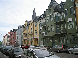
Ullanlinna is a city district of Helsinki, in Finland. The name Ullanlinna refers to the fortification line that was built at the southern edge of the area during the 18th century, as part of the town fortifications, which also included the fortress of Suomenlinna. The name Ulla refers to the Swedish Queen Ulrika Eleonora (1688–1741). During the 19th century the area was dominated by summer pavilions owned by the wealthy Helsinki middle-classes. The appearance of the area changed gradually at the end of the 19th century as the wooden houses were replaced with much higher stone buildings, designed in the prevailing Jugendstil architectural style synonymous with National Romanticism.

Vyborg is a town in, and the administrative center of, Vyborgsky District in Leningrad Oblast, Russia. It lies on the Karelian Isthmus near the head of the Vyborg Bay, 130 km to the northwest of St. Petersburg, 245 km east of the Finnish capital Helsinki, and 38 km south of Russia's border with Finland, where the Saimaa Canal enters the Gulf of Finland. The population of Vyborg is as follows: 79,962 (2010 Census); 79,224 (2002 Census); 80,924 (1989 Census).

The Helsinki Central Library Oodi, commonly referred to as Oodi, is a public library in Helsinki, Finland. The library is situated in the Kluuvi district, close to Helsinki Central Station and next to Helsinki Music Centre and Kiasma Museum of Contemporary Art. Despite its name, the library is not the main library in the Helsinki City Library system, which is located in Pasila instead.