Last updated • 2 min readFrom Wikipedia, The Free Encyclopedia
This article may be expanded with text translated from the corresponding article in Finnish. (December 2009)Click [show] for important translation instructions.
View a machine-translated version of the Finnish article.
Machine translation like DeepL or Google Translate is a useful starting point for translations, but translators must revise errors as necessary and confirm that the translation is accurate, rather than simply copy-pasting machine-translated text into the English Wikipedia.
Do not translate text that appears unreliable or low-quality. If possible, verify the text with references provided in the foreign-language article.
You must provide copyright attribution in the edit summary accompanying your translation by providing an interlanguage link to the source of your translation. A model attribution edit summary is Content in this edit is translated from the existing Finnish Wikipedia article at [[:fi:Linjat (Helsinki)]]; see its history for attribution.
You should also add the template {{Translated|fi|Linjat (Helsinki)}} to the talk page.
Linjat (Finnish), Linjerna (Swedish) is a neighborhood of the Kallio district of Helsinki, Finland. Its name literally means "The Lines" and comes from the five parallel streets named 1st, 2nd, 3rd, 4th and 5th Line (Ensi, Toinen, Kolmas, Neljäs and Viides linja (Finnish) / Första, Andra, Tredje, Fjärde, Femte linjen (Swedish)), which start at Hämeentie (Sw.: Tavastvägen) and run north-west, except for the much shorter Ensi linja, which starts at the southern end of Suonionkatu. The district lies to the north of Hakaniemi and Siltasaari and to the south of Alppiharju.
The boundaries of Linjat are the eastern shore of Töölönlähti Bay (west), Helsinginkatu (north), Kaarlenkatu and Viides linja, cutting Karhupuisto Park in half (east) and Hämeentie (from Viides linja to Toinen linja), Toinen linja and Porthaninrinne (south).
The area is served by the following public transport:
Metro Hakaniemi metro station's northern exit is at the junction of Porthaninkatu, Siltasaarenkatu and Toinen linja.
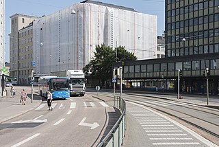
Tram Lines 3 and 9 run along Porthaninkatu, Viides linja and Kaarlenkatu, stopping at Kallion virastotalo (junction of Porthaninkatu and Toinen linja and Hakaniemi metro station northern exit), Karhupuisto (Viides linja) and Kaarlenkatu. In addition, lines 6 and 7 run along Hämeentie, stopping at Haapaniemi (corner of Viides linja). Also, tramlines 1 and 8 run along Helsinginkatu to the north of Linjat.
Tram stops Castreninkatu, Kuntatalo and Ensi linja are located at Ensi linja and Toinen linja. There is no regular traffic for them nowadays, but the tram tracks and the stops still exist. They can be used if the tram lines are on an exceptional route.
Bus Many routes leading to Vantaa, including the 615 to Helsinki-Vantaa Airport, run along Hämeentie, stopping at the Haapaniemi stop (from Helsinki: on the corner of Haapaniemenkatu; from airport: on the corner of Neljäs linja). Route 51 (Hakaniemi - Konala) runs along Porthaninkatu, stopping at Helsingin virastotalo tram stop, before continuing onto Fleminginkatu, Franzéninkatu and Kaarlenkatu. Routes 23 (Helsinki Central Railway Station - Ruskeasuo), 53 (Hakaniemi - Munkkiniemi) and 503 (Merihaka - Matinkylä (Espoo)) run along Toinen linja and Alppikatu, stopping at Kallion virastotalo, Castréninkatu (Toinen linja 25), Kuntatalo (Toinen linja 33) and Wallininkatu (Alppikatu 9).
Culture and education Kallio library is situated at Viides linja 11, just across the boundary in the Torkkelinmäki sub-district. Kallio Primary School (Kallion ala-aste) is at Neljäs linja 11–15. The Helsinki City Theatre (Helsingin kaupunginteatteri) is at Ensimmäinen linja 2.
Vantaa is a city and municipality in Finland. It is part of the inner core of the Finnish Capital Region along with Helsinki, Espoo, and Kauniainen. With a population of 238,033, Vantaa is the fourth most populated city in Finland after Helsinki, Espoo and Tampere. Its administrative center is the Tikkurila district. Vantaa is bordered by Helsinki, the Finnish capital, to the south; Espoo to the southwest; Nurmijärvi to the northwest; Kerava and Tuusula to the north; and Sipoo to the east. The city encompasses 240.35 square kilometres (92.80 sq mi), of which 1.97 km2 (0.76 sq mi) is water.
Hakaniemi is an unofficial district of Helsinki, the Finnish capital. It covers most of the neighbourhood of Siltasaari. It is considered a part of the Helsinki city center. Historically, it was often associated with the working class and workers' associations. However, the cost of living has risen considerably in recent years and is now on par with that of the rest of central Helsinki.
Helsinki commuter rail is the commuter rail system serving Greater Helsinki, Finland. The network is part of the HSL network, and is operated by VR, the Finnish state-owned national railway company. Together with the Helsinki Metro, buses, and trams, the network forms the heart of Helsinki's public transportation infrastructure.
Kallio is a district and a neighbourhood in Helsinki, the capital of Finland, located on the eastern side of the Helsinki peninsula about one kilometre north from the city centre. It is one of the most densely populated areas in Finland. Kallio is separated from the city centre by the Siltasaarensalmi strait, over which is a bridge called Pitkäsilta. Traditionally, the bridge symbolizes the divide between the affluent centre and the more working class areas around Kallio.
Hakaniemi metro station is a station on the Helsinki Metro. It serves the central Helsinki districts of Hakaniemi and Kallio. Both lines M1 and M2 serve Hakaniemi. There are 28 bicycle parking spaces at the station.
Sörnäinen metro station is a station on the Helsinki Metro. It serves the central Helsinki districts of Sörnäinen and Kallio. Sörnäinen is the easternmost station on the system to be located underground.
Sörnäinen is a neighbourhood in the city of Helsinki, Finland.
Public transport in Helsinki consists of bus, tram, metro, local railway and ferry services. The system is managed by Helsinki Region Transport and covers Helsinki, Espoo, Kauniainen, Vantaa and the outlying Kerava, Kirkkonummi, Sipoo and Tuusula.
Hämeentie is the second longest street in Helsinki, Finland, and among its major thoroughfares. Hämeentie is a multi-lane street beginning at the Hakaniemi square in Siltasaari, and ending near Vanhankaupunginkoski on Koskelantie.
Vironniemi is a district of Helsinki, Finland, forming the core part of the city centre, thus also the central location of the Finnish governmental and financial decision making, and the location of Helsinki's most important churches. Vironniemi is the location of the Presidential Palace, the Palace of the Finnish Council of State, the Senate Square, the Helsinki Cathedral, the Uspenski Cathedral and the main office of the Bank of Finland.
Torkkelinmäki (Finnish), Torkelsbacken (Swedish) is a central neighborhood of Kallio, Helsinki, Finland. Its boundaries are Hämeentie on the east, Helsinginkatu on the north, Kaarlenkatu on the west and Viides linja on the south. Like elsewhere in Kallio, the area's apartments are small, for the most part consisting of one or two rooms.
The Helsinki Regional Transport Authority is the inter-municipal authority that maintains the public transportation network of the nine municipalities of Greater Helsinki, Finland.
Ympyrätalo is a circle-shaped office building located in the Hakaniemi district of Helsinki, Finland. The building is a local landmark.
Helsinki is Finland's only remaining city with tram traffic. Two other cities—Turku (see Turku tram) and Vyborg —have had tram systems. Vyborg abandoned its trams in 1957 after it was ceded to the Soviet Union after the end of World War II. Turku withdrew its trams in 1972.
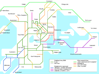
The city of Helsinki has plans for a radical expansion of the tram network within the 2021–2035 time horizon, as laid out in the Helsinki City Plan, approved by the City Council in October 2016. Below is a list of confirmed and proposed future expansions of the network. The largest confirmed projects are the 25-kilometre (16 mi) trunk line 550 ("Jokeri") and the 10-kilometre (6.2 mi) connection in the direction of East Helsinki to the island of Laajasalo, which will include the longest bridge in Finland. Together, these two will effectively double the track length of the network.
The Crown Bridges is the name given to three bridges under construction in the Finnish city of Helsinki, creating a new tram link and cycle path to the island of Laajasalo.
Kalasatama is a neighbourhood in the city of Helsinki, Finland. The area is officially part of the Sörnäinen district; and like Sörnäinen, Kalasatama is located a little more than one kilometre north from the coastal centre of Helsinki, near the district of Hakaniemi, and the east side of Kalasatama borders the sea. Itäväylä, which leads in the direction of East Helsinki, runs next to Kalasatama. The Isoisänsilta pedestrian and cycling bridge, opened in 2016, connects Kalasatama to the nearby islands of Mustikkamaa, Korkeasaari and Kulosaari.
The Sörnäinen curve, also known as Sörkän kurvi or just Kurvi, is an area in the eastern part of the Helsinki city proper in Finland, at the intersection point of the neighbourhoods of Sörnäinen, Kallio and Alppiharju. The area is located around the point where the street Hämeentie curves to the right going north and the street Helsinginkatu branches off it to the west. The curve area covers the whole area on the intersection of Helsinginkatu and Hämeentie. The curve serves as a hub for many public transport connections, including the Sörnäinen metro station. One of the former landmarks of the curve was the building of the insurance company Kansa and the light tower located on top of it.
Helsinginkatu is a two-kilometre-long east-west-running street in Helsinki, Finland. The street runs from Hämeentie to Mannerheimintie. The street separates the districts of Kallio and Alppiharju, however the part west to the railway underpass belongs to Taka-Töölö. The eastern part of the street is a 30-metre-wide avenue, with buildings on both sides. Between the avenue part and the railway underpass there are only buildings on the southern side of the street, except for the Helsinki Sports House. To the west of the railway the street runs along the shore of the Töölönlahti bay and the only buildings on it are the Finnish National Opera and Ballet and restaurant Töölönranta. Helsinginkatu is lit with lights hanging from wires and paved with asphalt throughout its length. There is also a tram track running throughout the street.
This page is based on this Wikipedia article Text is available under the CC BY-SA 4.0 license; additional terms may apply. Images, videos and audio are available under their respective licenses.