Vuosaari is a neighbourhood in the City of Helsinki, Finland. It is located by the sea in East Helsinki and with its area of 15.38 km2 (5.94 sq mi) is geographically the largest district in the city. It also has two Helsinki Metro stations, Rastila and Vuosaari

The Helsinki Metro is a rapid transit system serving the Helsinki capital region, Finland. It is the world's northernmost metro system. It was opened to the general public on 2 August 1982 after 27 years of planning. It is operated by Helsinki City Transport and Metropolitan Area Transport Ltd for Helsinki Regional Transport Authority and carries 92.6 million passengers per year.

Herttoniemi is an East Helsinki neighbourhood and a suburb of Helsinki, the Finnish capital.

Ruoholahti is a quarter in Helsinki, part of the Länsisatama neighbourhood and Kampinmalmi district. It is located in the southwestern part of the central city area of Helsinki, close to the Lauttasaari island, and it functions as the principal connection between the Helsinki city centre and the city of Espoo to the west. As of 2005 Ruoholahti is inhabited by approx. 3300 people. The Länsisatama port is also situated in Ruoholahti.

Arabianranta, sometimes simply Arabia, is a residential part of Helsinki, Finland. It is bound by Vanhankaupunginlahti bay from east, and connects to neighboring boroughs of Vanhakaupunki in north, Hermanni in south and Toukola and Kumpula in west. It is part of the greater Toukola region.

Kontula is a quarter of Helsinki, Finland, part of the Mellunkylä neighbourhood. Kontula was built mostly in the 1960s and 1970s when more housing was required in Helsinki. Many people from the city centre moved to Kontula; due to its little higher than average concentration of government tenant housing complexes, immigrant and refugee population it is regarded as an average eastern Helsinki suburb.

Rastila metro station is a ground-level station on the M1 line of the Helsinki Metro. There are 134 bicycle and 34 car parking spaces at Rastila. It serves the residential areas of Meri-Rastila and Rastila in the district of Vuosaari, in East Helsinki.

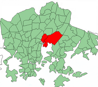
Sörnäinen is a neighbourhood in the city of Helsinki, Finland.

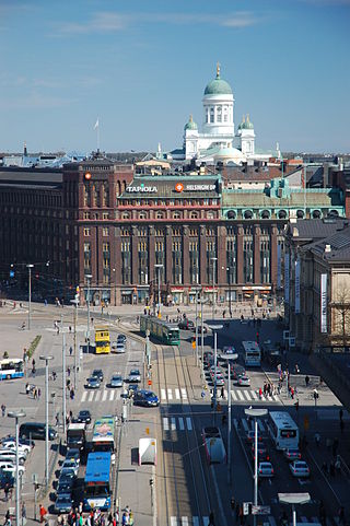
Pasila station is a railway station in Helsinki, Finland, approximately 3.5 kilometres (2.2 mi) north of Helsinki Central. It is the second busiest railway station in Finland, after Helsinki Central, and takes up a large part of the district of Pasila. The station was first opened in 1862 along the Finnish Main Line. The current station building opened in 2019.
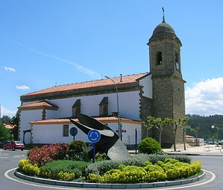
Sopela, formerly known as Sopelana, is a town and municipality located in the province of Biscay, in the autonomous community of Basque Country, northern Spain. The town is roughly 820 hectares in size, located in the comarca Mungialdea on the north east side of Bilbao and due east of the Nervión river estuary. In the municipality, other former towns like Larrabasterra were annexed to make Sopela larger. The population is 13,878 people, as recorded in the 2019 census. The area of Sopela is situated among green hills and beaches. This makes it a very attractive suburb of Greater Bilbao, with a short commute of 35 minutes on the metro.
Viikki is a neighbourhood of about 15,000 inhabitants in Helsinki, Finland. It is located at the bottom of Vanhankaupunginlahti bay, some 7–10 km from the city centre.

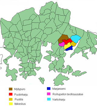
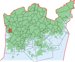
East Helsinki is an area in Helsinki, Finland, usually thought to comprise the city's eastern and south-eastern major districts, including the districts of Vartiokylä, Myllypuro, Mellunkylä, Vuosaari, Herttoniemi, Laajasalo and Kulosaari. With the exception of Kulosaari, the buildings in the area are relatively new – most have been built in the 1960s or later – and constitute relatively densely inhabited suburbs, except for the southern part of Laajasalo and most of Kulosaari. On the other side of the bridge to the west of Kulosaari is Helsinki Downtown, the so-called "South Helsinki". Officially, the name "East Helsinki" is not found in the city's regional nomenclature, but it was a name created by the locals of the area.

Kalasatama metro station is a ground-level station on the Helsinki Metro, in the capital city of Finland. The station was opened on 1 January 2007, and it serves the eastern part of the central Helsinki district of Sörnäinen's quarter Kalasatama. The area is mainly composed of offices and apartments, with new residential and commercial developments being under construction in the area, including the shopping center Redi. The port facilities previously in the area were moved to Vuosaari Harbour in 2008.
Vuosaari Harbour is a seaport facility in Helsinki, Finland, opened in November 2008. Its gatehouse is also currently the 25th tallest building in Finland.
Kluuvi is the commercial centre of Helsinki, Finland, and a neighbourhood in the Vironniemi district of Helsinki. The Helsinki Central railway station, Hotel Kämp and Hotel Arthur, the Helsinki main post office, the Stockmann and Sokos department stores, the Kluuvi shopping centre and the main offices of Finnish banks are located in Kluuvi. Kluuvi includes the central campus of the University of Helsinki, the Ateneum art museum, and the movie theatres Maxim, Kinopalatsi and Bristol. The northeastern part of Kluuvi, which includes the Kaisaniemi park, is commonly called Kaisaniemi, but it is not the official name of any neighbourhood in Helsinki.
Vartiokylä is a neighbourhood in the East Helsinki area of Helsinki, the capital of Finland. Its name is derived from the ruins of an eleventh-century fortress on the Linnanvuori hill in Vartioharju, one of Vartiokylä's subdivisions. The working population of Helsinki started building their houses in the area after the completion of Uusi Porvoontie, a road to the downtown, in the 1930s. Nowadays the area has a few high density apartment areas as well as houses. Vartiokylä became a part of Helsinki in 1946. Most of the services in the district are located in the subdivision of Itäkeskus, in the area around one of the largest shopping centers in the Nordic countries.
Munkkivuori is a quarter of the Munkkiniemi neighbourhood in Helsinki. The buildings and the plan of site are typical of the late 1950s. Most of the residential buildings in Munkkivuori are within a loop formed by Ulvilantie ring road. The automotive traffic to the residential buildings is routed along Ulvilantie whereas Raumantie no through road terminating in the center of the Ulvilantie loop provides access to public services and limits the through-traffic in residential areas. A designed network of crushed stone walkways provides easy accessibility around Munkkivuori for cyclists, pedestrians and other non-automotive traffic.

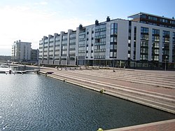
Kalasatama is a neighbourhood in the city of Helsinki, Finland. The area is officially part of the Sörnäinen district; and like Sörnäinen, Kalasatama is located a little more than one kilometre north from the coastal centre of Helsinki, near the district of Hakaniemi, and the east side of Kalasatama borders the sea. Itäväylä, which leads in the direction of East Helsinki, runs next to Kalasatama. The Isoisänsilta pedestrian and cycling bridge, opened in 2016, connects Kalasatama to the nearby islands of Mustikkamaa, Korkeasaari and Kulosaari.

Columbus is a shopping centre in Vuosaari, Helsinki, Finland, right next to the Vuosaari metro station. It is owned by Citycon. The centre was completed in August 1996. The centre has a total surface area of over 20,000 m2 (220,000 sq ft).

Vuotalo is a cultural centre located in Vuosaari, Helsinki, Finland north of the Mosaiikkitori square, near the Columbus shopping centre, the Vuosaari metro station, the Vuosaari sports hall and the Vuosaari high school. The building was designed by Mikko Heikkinen and Markku Komonen and it was completed in 2001.