
Vuosaari is a neighbourhood in the City of Helsinki, Finland. It is located by the sea in East Helsinki and with its area of 15.38 km2 (5.94 sq mi) is geographically the largest district in the city. It also has two Helsinki Metro stations, Rastila and Vuosaari

Katajanokka is a neighbourhood of Helsinki, Finland, with around 4000 inhabitants in 2005. The district is located adjacent to the immediate downtown area, though in the first major town plan for Helsinki from the mid-18th century, the area fell outside the fortifications planned to encircle the city.

Herttoniemi is an East Helsinki neighbourhood and a suburb of Helsinki, the Finnish capital.

Arabianranta, sometimes simply Arabia, is a residential part of Helsinki, Finland. It is bound by Vanhankaupunginlahti bay from east, and connects to neighboring boroughs of Vanhakaupunki in north, Hermanni in south and Toukola and Kumpula in west. It is part of the greater Toukola region.

Lauttasaari is an island in Helsinki, Finland, about 3 kilometres (1.9 mi) west of the city centre. Together with some surrounding unpopulated small islands, Lauttasaari is also a district of Helsinki. With 23,226 residents as of 2017, the island is Finland's second largest by population, after Fasta Åland. Its land area is 3.85 km2.

Sörnäinen is a neighbourhood in the city of Helsinki, Finland.
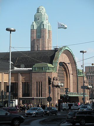
Helsinki Central Station (HEC) is the main station for commuter rail and long-distance trains departing from Helsinki, Finland. About 200,000 people "pass through the station" every day, half of whom are train passengers. The station serves as the terminus for all trains in the Helsinki commuter rail network, as well as for all Helsinki-bound long-distance trains in Finland. The Rautatientori metro station is located in the same building.

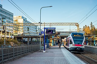
Pasila station is a railway station in Helsinki, Finland, approximately 3.5 kilometres (2.2 mi) north of Helsinki Central. It is the second busiest railway station in Finland, after Helsinki Central, and takes up a large part of the district of Pasila. The station was first opened in 1862 along the Finnish Main Line. The current station building opened in 2019.
Viikki is a neighbourhood of about 15,000 inhabitants in Helsinki, Finland. It is located at the bottom of Vanhankaupunginlahti bay, some 7–10 km from the city centre.
The city of Helsinki, the capital of Finland, can be divided into various sorts of subdivisions. Helsinki is divided into three major areas: Helsinki Downtown, North Helsinki and East Helsinki. The subdivisions include boroughs, districts, major districts and postal code areas. The plethora of different official ways to divide the city is a source of some confusion to the inhabitants, as different kinds of subdivisions often share similar or identical names.

Keilaniemi is a district in the south-eastern part of Espoo, Finland.

Tampere Central Station is a functionalist building in Tampere, Finland, designed by Eero Seppälä and Otto Flodin, completed in 1936. The station is one of the most important railway stations in Finland. In 2015, the Tampere Central Station was the second busiest railway station in Finland in terms of numbers of passengers, after the Helsinki Central Station.

Leppävaara is a district of Espoo, a city in Finland. The Rantarata rail line and the Ring Road I, the busiest road in Finland, cross in Leppävaara, thus making it a major traffic hub in the Greater Helsinki region. The Sello Shopping Centre is also located in Leppävaara.
Käpylä (Finnish) or Kottby (Swedish) is a railway station in the Käpylä district of Helsinki, Finland. It is located between the stations of Pasila and Oulunkylä, along the main railroad track from Helsinki to Riihimäki, about 6 km north from the Helsinki Central railway station.

Oulunkylä railway station is a railway station in the Oulunkylä district of Helsinki, Finland. It is located between the stations of Käpylä and Pukinmäki, along the main railroad track from Helsinki to Riihimäki, about 7 kilometres (4 mi) north of the Helsinki Central railway station.

Käpylä is a neighbourhood of Helsinki with 7,600 inhabitants. Administratively speaking, Käpylä is a part of the Vanhakaupunki district.
Munkkivuori is a quarter of the Munkkiniemi neighbourhood in Helsinki. The buildings and the plan of site are typical of the late 1950s. Most of the residential buildings in Munkkivuori are within a loop formed by Ulvilantie ring road. The automotive traffic to the residential buildings is routed along Ulvilantie whereas Raumantie no through road terminating in the center of the Ulvilantie loop provides access to public services and limits the through-traffic in residential areas. A designed network of crushed stone walkways provides easy accessibility around Munkkivuori for cyclists, pedestrians and other non-automotive traffic.
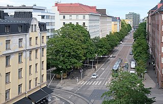
Helsinginkatu is a two-kilometre-long east-west-running street in Helsinki, Finland. The street runs from Hämeentie to Mannerheimintie. The street separates the districts of Kallio and Alppiharju, however the part west to the railway underpass belongs to Taka-Töölö. The eastern part of the street is a 30-metre-wide avenue, with buildings on both sides. Between the avenue part and the railway underpass there are only buildings on the southern side of the street, except for the Helsinki Sports House. To the west of the railway the street runs along the shore of the Töölönlahti bay and the only buildings on it are the Finnish National Opera and Ballet and restaurant Töölönranta. Helsinginkatu is lit with lights hanging from wires and paved with asphalt throughout its length. There is also a tram track running throughout the street.

Hakaniemenranta is a street on the Siltavuorensalmi shore in central Helsinki, Finland. The street belongs to two separate districts: the western part belongs to Hakaniemi in Kallio, while the eastern part belongs to the Merihaka residential area in Sörnäinen.

Sompasaari is an island on the Kruunuvuorenselkä water area in the Sörnäinen district in Helsinki, Finland. On the southern side of the Nihdinkanava channel built in the middle of Sompasaari is the island of Nihti.

