History of Victoria Peak

Last updated

Hong Kong's Peak District was original named the "Hill District". It included Mount Austin (with Victoria Peak), Mount Gough, Mount Kellett and the area around Magazine Gap. [1] Many homes were for summer use only, to escape the heat of Central, and were referred to as "bungalows". Over time, they were given names, especially when the bungalows were rebuilt in brick or stone as substantial mansions, allowing them to better withstand the damage from typhoons.

Contents

The accessible land on the Peak was first divided by Government into plots called Farm Lots (FL). Later, Rural Building Lots (RBL) were introduced. All lots were numbered in the order they were made available to the public. By this we can see how The Peak developed. [2]

1860s - the earliest days

In 1860 Governor Robinson , age 35, had a path cut wide enough for sedan chairs starting at what is now Robinson Road, just above the Botanical Gardens, then climbing to Victoria Gap (today called Old Peak Road) and on to the top of Victoria Peak (today called Mount Austin Road). At the time, the hillside was bare rock.

The Signal Station [3] at the top of Victoria Peak, for the signalmen, was the very first house on the Peak. In 1860, a path was also laid from Victoria Gap down to Pok Fu Lam Village in 1863.

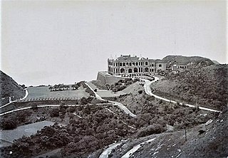
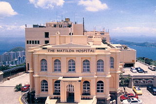
A small Military Hospital called the Sanatorium was built 1860 as an experiment, on a flat area below the signal station and facing toward Mt. Kellett. Unfortunately, the higher elevation did not help the 17 patients recover any faster than elsewhere in Hong Kong, and so the Sanatorium was abandoned. [4] Then, Granville and Matilda Sharp (after whom Matilda International Hospital is named), lived there in the summers of 1866 and 1867, until, as she wrote, "the Governor wanted it". [5] Governor MacDonnell did want it. The Sharps were turfed out and the Sanatorium purchased from the Military. The first Mountain Lodge was built [6] in about 1867, as the summer residence of the Governor.

Police Station No. 6 was built at Victoria Gap, in 1869, two years later, just across the road from what is now the "Peak Lookout" restaurant.

1870 - 1886

55 houses at the Peak by Lai Afong, c1880s No 12 View at Peak Hill by Lai Afong.jpg
55 houses at the Peak by Lai Afong, c1880s

In 1874, more sedan chair paths and wells were provided, and this created a building boom.

Others built. So many, in fact, that there were enough people disinclined to make the trek down the hill and up again a Sunday to the Cathedral, that a wee Anglican chapel of ease, The Peak Church, was built in 1883. It was nicknamed the "Jelly Mould". [15]

With the growth of the district, the Police built a new station on Gough Hill (the same site it is on today).

1888 - Peak Tram Opened

Once the Peak Tram opened, the Peak stopped being only a place for a summer home, it was now easy to live there year-round. Two hotels opened - the Peak Hotel and the Mount Austin Hotel. This is when the Peak began to be the residence of choice for many non-Chinese. All Chinese people were restricted from living on the Peak by the Peak District Reservation Ordinance 1904 which was repealed in 1930. Since the late 1900s, the Peak has become the residence of choice for many wealthy and powerful figures in the city.

See also

Related Research Articles

<span class="mw-page-title-main">Victoria Peak</span> Hill in Hong Kong

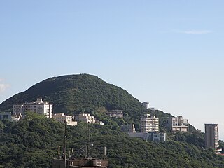
Victoria Peak is a hill on the western half of Hong Kong Island. It is also known as Mount Austin, and locally as The Peak only generally. With an elevation of 552 metres (1,811 ft), it is the tallest hill on Hong Kong Island, and the 29th tallest in the territory of Hong Kong. It is a major tourist attraction offering views of Central, Victoria Harbour, Lamma Island and the surrounding islands.

<span class="mw-page-title-main">Kellett Island</span> Former island of Hong Kong

Kellett Island is a former island of Victoria Harbour, off East Point in Hong Kong. It is now connected to Hong Kong Island at Causeway Bay following land reclamation in 1969.

<span class="mw-page-title-main">Jardine's Lookout</span> Mountain in Wan Chai District, Hong Kong

Jardine's Lookout is a mountain in Wan Chai District, Hong Kong with a height of 433 metres (1,421 ft). It is located east of Happy Valley, south of Causeway Bay, and west of Braemar Hill and north of Tai Tam Country Park.

<span class="mw-page-title-main">Devil's Peak, Hong Kong</span> Peak in Hong Kong

Devil's Peak is a peak in Sai Kung District, Hong Kong. The communities of Tiu Keng Leng, Lei Yue Mun and Yau Tong surround this peak.

<span class="mw-page-title-main">Mount Davis, Hong Kong</span> Mountain in Hong Kong

Mount Davis or Mo Sing Leng is an area surrounding and including the westernmost hill on Hong Kong Island, Hong Kong. It is 269m tall. Home to mostly luxury residences, Mount Davis was originally settled after the construction of Victoria Road, Hong Kong by prominent Hong Kong families who were unable to live on Peak due to the zoning restriction in Peak District Reservation Ordinance, 1904.

<span class="mw-page-title-main">Mount Gough</span>

Mount Gough is a peak on Hong Kong Island, Hong Kong. It lies directly east of Victoria Peak and rises to a height of 479 metres (1,572 ft) above Admiralty. It is named for Hugh Gough, 1st Viscount Gough, Commander-in-Chief of British Forces in China. The summit is now occupied by a housing complex so is inaccessible to the general public.

<span class="mw-page-title-main">Mountain Lodge</span> Hong Kong Governor summer residence

Mountain Lodge was the former summer residence of the Governor of Hong Kong on Victoria Peak on the Hong Kong Island in Hong Kong. The second building was a two-storey Renaissance style home and was demolished in 1946. The site is now the Victoria Peak Garden, a public park. The Gate Lodge, which originally served as living quarters for the keeper of Mountain Lodge, is still extant.

<span class="mw-page-title-main">Mount Nicholson</span>

Mount Nicholson is a 430 m (1,411 ft) tall mountain located in Wan Chai District, on Hong Kong Island, Hong Kong. The hill is believed to be named for Hong Kong Volunteer Corps Adjunct Lieutenant W.C.A. Nicholson.

<span class="mw-page-title-main">The Peak Hotel</span> Building in Victoria Peak, Hong Kong

The Peak Hotel was a hotel located at Victoria Gap, at upper terminus of the Peak Tram, near the summit of Victoria Peak on Hong Kong Island, Hong Kong. It started as a bar and restaurant, and a hotel with twenty bedrooms for summer visitors opening about the same time as the Peak Tram, in 1888.

<span class="mw-page-title-main">Matilda International Hospital</span> Hospital in The Peak, Hong Kong

Matilda International Hospital is a For-profit Community Hospital in Hong Kong located at 41 Mount Kellett Road, The Peak, Hong Kong Island. The hospital was built as a result of the last will and testament of Granville Sharp, the husband of Matilda Lincolne Sharp. Granville Sharp was a successful banker descended from the well-known Sharp family of Romsey, Hampshire, United Kingdom, another member of which was 'Conversation' Sharp.

<span class="mw-page-title-main">Royal Naval Hospital (Hong Kong)</span> Former hospital in Hong Kong Island, Hong Kong

Royal Naval Hospital (Hong Kong) was the Royal Navy's medical facility in the colony.

<span class="mw-page-title-main">Peak Church</span>

The Mt. Gough Peak Protestant Church, also called the Peak Church was a Protestant chapel of ease in the Peak District of Hong Kong Island and held its first service in June 1883. It was "... an unpretending structure in the similitude of a jelly mould ..." which explains its affectionate nickname The Jelly Mould.

<span class="mw-page-title-main">Peak School</span> Private school in Hong Kong

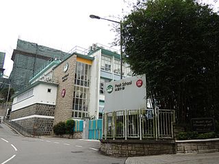
Peak School is a coeducational preparatory school, located on Plunkett's Road on Victoria Peak, Hong Kong Island, Hong Kong. The school is one of around twenty institutions in Hong Kong operated by the English Schools Foundation (ESF).

<span class="mw-page-title-main">Victoria Gap</span> Mountain pass in Hong Kong

Victoria Gap is an area and a mountain pass located between the summits of Victoria Peak and Mount Gough, on Hong Kong Island, in Hong Kong. It is the most touristic place within the area referred to as The Peak, which receives some seven million visitors every year. Its altitude is 396 metres (1,299 ft) - some 150 metres (490 ft) below the summit of The Peak.

<span class="mw-page-title-main">Peak District Reservation Ordinance 1904</span>

The Peak District Reservation Ordinance 1904, originally enacted as the Hill District Reservation Ordinance, is commonly called the Peak Reservation Ordinance and was a zoning law that reserved most of the Victoria Peak as a place of residence to non-Chinese people except with the consent of the Governor-in-Council. The law was in force from 1904 to 1930 where the deadly Third Pandemic of Bubonic plague took place in China, causing 100,000 deaths, and enormous number of Chinese influxed into Hong Kong, causing the 1894 Hong Kong plague. Contemporary historians’ views toward the Ordinance vary, with some attributing the Ordinance to health segregation, whereas others attribute it to social status segregation. The debate on the second reading of the Bill is recorded in the Hong Kong Hansard, which shows that the two Chinese members, Ho Kai and Wei Yuk, did not oppose the Bill but a minority of the "leading Chinese" in the community were against it.

<span class="mw-page-title-main">Lugard Road</span>

Lugard Road is a road located on Victoria Peak, Hong Kong, named after Sir Frederick Lugard, Governor of Hong Kong from 1907 to 1912. Located some 400 metres (1,300 ft) above sea level, the road is a popular walking path that forms part of the Hong Kong Trail, and is known for spectacular vistas over Victoria Harbour.

<span class="mw-page-title-main">Mount Cameron (Hong Kong)</span> Hill in Hong Kong

Mount Cameron is a 439-metre (1,440 ft) high hill in Hong Kong. Located within the Aberdeen Country Park, it was likely named for Major General William Gordon Cameron, British Army officer and former Administrator of Hong Kong.

<span class="mw-page-title-main">Barker Road</span> Road on Victoria Peak, Hong Kong

Barker Road is a road located on Victoria Peak, Hong Kong at an altitude of approximately 350 metres above sea level with a length of about 1,7 km. It starts from the Old Peak Road and ends at Magazine Gap on Peak Road.

<span class="mw-page-title-main">Mount Kellett</span> Mountain on Hong Kong Island

Mount Kellett is a 501-metre-high (1,644 ft) mountain on Hong Kong Island, Hong Kong. It was likely named after British Royal Navy Vice Admiral Henry Kellett, the captain of HMS Starling in the 19th century.

<span class="mw-page-title-main">Peak Road</span> Road in Hong Kong

Peak Road is a road in The Peak on Hong Kong Island, Hong Kong. It is the only road to travel from Victoria Gap to Wan Chai Gap on Hong Kong Island. The Peak Road is a two-lane two-way traffic, which can take buses, minibuses and other vehicles. The highest altitude is about 420 meters.

References

  1. PRO 1888 map
  2. hong Kong Public Records Office "Buildings - Peak"
  3. Signal Station - Hong Kong Public Records Office
  4. The United service magazine, September 1867
  5. Matilda : her life and legacy by Joyce Stevens Smith
  6. Public Records Office - The "first" Mountain Lodge
  7. September 2003, Austins of America, Page 823
  8. Public Records Office
  9. Austins of America
  10. Public Records Office - Photos of The Eyrie.
  11. Hong Kong Police History Archived 2009-04-02 at the Wayback Machine
  12. PRO
  13. Public Records Office - The Eyrie
  14. Travel Industry Council of Hong Kong (TIC): The Voice of TIC No.1 / 2013. p.23
  15. Peak Church - Hong Kong Public Records Office