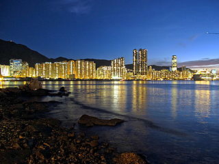
The Eastern District located on northeastern part of Hong Kong Island,being one of the 18 administrative districts of Hong Kong. It had a population of 529,603 in 2021 The district has the second highest population while its residents have the third highest median household income among the 18 districts.

Tuen Mun District is one of the 18 administrative districts of Hong Kong. It is the westernmost continental district of Hong Kong. It had a population of 506,879 in 2021. Of these,64 000 are under the age of 18. Part of the district is the Tuen Mun New Town,which contains one of the largest residential areas in the New Territories.

Hong Kong Island is an island in the southern part of Hong Kong. The island,known originally and on road signs simply as "Hong Kong",had a population of 1,289,500 and a population density of 16,390 per square kilometre (42,400/sq mi),as of 2008. The island had a population of about 3,000 inhabitants scattered in a dozen fishing villages when it was occupied by the United Kingdom in the First Opium War (1839–1842). In 1842,the island was formally ceded in perpetuity to the UK under the Treaty of Nanking and the City of Victoria was then established on the island by the British Force in honour of Queen Victoria. The Central area on the island is the historical,political and economic centre of Hong Kong. The northern coast of the island forms the southern shore of the Victoria Harbour,which is largely responsible for the development of Hong Kong due to its deep waters favoured by large trade ships.

Lantau Island is the largest island in Hong Kong,located west of Hong Kong Island and the Kowloon Peninsula,and is part of the New Territories. Administratively,most of Lantau Island is part of the Islands District of Hong Kong. A small northeastern portion of the island is located in the Tsuen Wan District.

Central is the central business district of Hong Kong. It is located in the northeastern corner of the Central and Western District,on the north shore of Hong Kong Island,across Victoria Harbour from Tsim Sha Tsui,the southernmost point of Kowloon Peninsula. The area was the heart of Victoria City,although that name is rarely used today.

Hong Kong Tramways (HKT) is a 3 ft 6 in narrow-gauge tram system in Hong Kong. Owned and operated by RATP Dev,the tramway runs on Hong Kong Island between Kennedy Town and Shau Kei Wan,with a branch circulating through Happy Valley.

Victoria Peak is a hill on the western half of Hong Kong Island. It is also known as Mount Austin,and locally as The Peak only generally. With an elevation of 552 metres (1,811 ft),it is the tallest hill on Hong Kong Island,and the 29th tallest in the territory of Hong Kong. It is a major tourist attraction offering views of Central,Victoria Harbour,Lamma Island and the surrounding islands.

The Peak Tram is a funicular railway in Hong Kong,which carries both tourists and residents to the upper levels of Hong Kong Island. Running from Garden Road Admiralty to Victoria Peak via the Mid-Levels,it provides the most direct route and offers good views over the harbour and skyscrapers of Hong Kong. Operated since 1888,it was the first funicular railway in Asia.

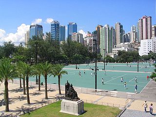
Victoria Park is a public park in Causeway Bay,Wan Chai District,Hong Kong. The park is named after Queen Victoria,who has a statue in the park. It is around 190,000 square metres (19 ha) in size and contains sporting facilities for tennis,association football,basketball,handball,volleyball,swimming,jogging,fitness,roller skating,and bowling.

Mid-Levels is an affluent residential area on Hong Kong Island in Hong Kong. It is located between Victoria Peak and Central. Residents are predominantly more affluent Hong Kong locals and expatriate professionals.

Sheung Wan is an area in Hong Kong,located in the north-west of Hong Kong Island,between Central and Sai Ying Pun. Administratively,it is part of the Central and Western District. The name can be variously interpreted as Upper District,or Gateway District.

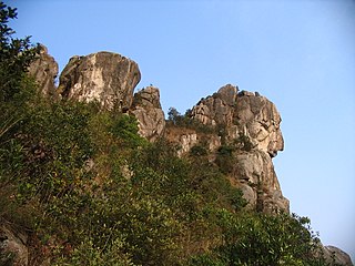
Lion Rock,or less formally Lion Rock Hill,is a mountain in Hong Kong. It is located in Sha Tin District,between Kowloon Tong of Kowloon and Tai Wai of the New Territories,and is 495 metres (1,624 ft) high. The peak consists of granite covered sparsely by shrubs. The Kowloon granite,which includes Lion Rock,is estimated to be around 140 million years old.

Jardine's Lookout is a mountain in Wan Chai District,Hong Kong with a height of 433 metres (1,421 ft). It is located east of Happy Valley,south of Causeway Bay,and west of Braemar Hill and north of Tai Tam Country Park.

Sai Ying Pun is an area in Sai Wan,on Hong Kong Island,in Hong Kong. It is administratively part of the Central and Western District.

Conduit Road is a road in the Mid-Levels on Hong Kong Island in Hong Kong.

MacDonnell Road is a street in the Mid-Levels area of Hong Kong Island,Hong Kong.
Hong Kong's Peak District was original named the "Hill District". It included Mount Austin,Mount Gough,Mount Kellett and the area around Magazine Gap. Many homes were for summer use only,to escape the heat of Central,and were referred to as "bungalows". Over time,they were given names,especially when the bungalows were rebuilt in brick or stone as substantial mansions,allowing them to better withstand the damage from typhoons.

The Central and Western District located on northwestern part of Hong Kong Island is one of the 18 administrative districts of Hong Kong. It had a population of 243,266 in 2016. The district has the most educated residents with the second highest income and the third lowest population due to its relatively small size.

Barker Road is a road located on Victoria Peak,Hong Kong at an altitude of approximately 350 metres above sea level with a length of about 1,7 km. It starts from the Old Peak Road and ends at Magazine Gap on Peak Road.

Peak Road is a road in The Peak on Hong Kong Island,Hong Kong. It is the only road to travel from Victoria Gap to Wan Chai Gap on Hong Kong Island. The Peak Road is a two-lane two-way traffic,which can take buses,minibuses and other vehicles. The highest altitude is about 420 meters.


