Hoehne, Colorado

Last updated

Hoehne, Colorado
Hoehne, Colorado.JPG
County Road 40.6 in Hoehne.
Las Animas County Colorado Incorporated and Unincorporated areas Hoehne Highlighted 0836940.svg
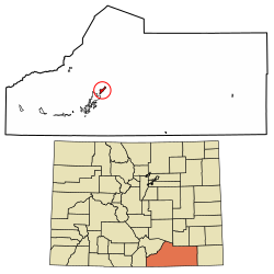
Location of the Hoehne CDP in Las Animas County, Colorado.
Usa edcp location map.svg
Red pog.svg
Hoehne
Location of the Hoehne CDP in the United States.
Coordinates: 37°17′20″N104°22′40″W / 37.28889°N 104.37778°W / 37.28889; -104.37778 (Hoehne CDP, Colorado) [1]
Country Flag of the United States.svg  United States
State Flag of Colorado.svg  Colorado
County Las Animas County
Founded1859
Government
  Type unincorporated town
Area
[1]
  Total3.107 sq mi (8.046 km2)
  Land3.107 sq mi (8.046 km2)
  Water0.000 sq mi (0.000 km2)
Elevation
[2]
5,738 ft (1,749 m)
Population
 (2020) [3]
  Total80
  Density26/sq mi (9.9/km2)
Time zone UTC-7 (MST)
  Summer (DST) UTC-6 (MDT)
ZIP Code [4]
81046
Area code 719
GNIS feature ID 2583247 [2]

Hoehne is an unincorporated town, a post office, and a census-designated place (CDP) located in and governed by Las Animas County, Colorado, United States. At the United States Census 2020, the population of the Hoehne CDP was 80. [3]

Contents

History

Hoehne was founded by German immigrant William Hoehne in 1859 in what was then the Territory of New Mexico. He is credited with founding the Hoehne Ditch Company and introducing the first mill and threshing machine into the area. [5] William Hoehne farmed 1,000 acres (400 ha), planting strawberries, apples, and cherries. Hoehne is still a farming community, but the focus has shifted from fruits to alfalfa and grass hay.

The population of Hoehne today is around 80 people. But during its heyday, the town boasted a hotel, a train depot called "Hoehnes", a blacksmith, a Catholic church, and several stores. The train depot was retired in 1967 and was moved twice - the second time to its current location in Texas Creek, where it was restored to its original condition. [6] The Hoehne train depot sign is still visible today at the original depot location.

Hoehne is located near the Santa Fe Trail, and a historical marker is located approximately one mile north of the town on County Road 42.0.

Geography

Hoehne is located in west-central Las Animas County on high ground north of the Purgatoire River. It is 11 miles (18 km) northeast of Trinidad, the county seat.

The Hoehne CDP has an area of 1,988 acres (8.046 km2), all land. [1]

Demographics

The United States Census Bureau initially defined the Hoehne CDP for the United States Census 2010.

Hoehne CDP, Colorado
YearPop.±%
2010 111    
2020 80−27.9%
Source: United States Census Bureau

Notable residents

See also

Related Research Articles

<span class="mw-page-title-main">Otero County, Colorado</span> County in Colorado, United States

Otero County is a county located in the U.S. state of Colorado. As of the 2020 census, the population was 18,690. The county seat is La Junta. The county was named for Miguel Antonio Otero, one of the founders of the town of La Junta and a member of a prominent Hispanic family.

<span class="mw-page-title-main">Las Animas County, Colorado</span> County in Colorado, United States

Las Animas County is a county located in the U.S. state of Colorado. As of the 2020 census, the population was 14,555. The county seat is Trinidad. The county takes its name from the Mexican Spanish name of the Purgatoire River, originally called El Río de las Ánimas Perdidas en el Purgatorio, which means "River of the Lost Souls in Purgatory."

<span class="mw-page-title-main">Bent County, Colorado</span> County in Colorado, United States

Bent County is a county located in the U.S. state of Colorado. As of the 2020 census, the population was 5,650. The county seat and only incorporated municipality is Las Animas. The county is named in honor of frontier trader William Bent.

<span class="mw-page-title-main">Baca County, Colorado</span> County in Colorado, United States

Baca County is a county located in the U.S. state of Colorado. As of the 2020 census, the population was 3,506. The county seat is Springfield. Located at the southeast corner of Colorado, the county shares state borders with Kansas, New Mexico, and Oklahoma.

<span class="mw-page-title-main">Grand Canyon Village, Arizona</span> Town in Arizona, United States

Grand Canyon Village is a census-designated place (CDP) located on the South Rim of the Grand Canyon, in Coconino County, Arizona, United States. Its population was 2,004 at the 2010 Census. Located in Grand Canyon National Park, it is wholly focused on accommodating tourists visiting the canyon. Its origins trace back to the railroad completed from Williams, to the canyon's South Rim by the Santa Fe Railroad in 1901. Many of the structures in use today date from that period. The village contains numerous landmark buildings, and its historic core is a National Historic Landmark District, designated for its outstanding implementation of town design.

<span class="mw-page-title-main">Las Animas, Colorado</span> City in Colorado, United States

Las Animas is the statutory city that is the county seat, the most populous community, and the only incorporated municipality in Bent County, Colorado, United States. The city population was 2,300 at the 2020 United States Census. Las Animas is located on the Arkansas River, just west of its confluence with the Purgatoire River, in southeast Colorado east of Pueblo, near the historic Bent's Fort.

<span class="mw-page-title-main">Fort Garland, Colorado</span> Census Designated Place in Colorado, United States

Fort Garland is an unincorporated town, a post office, and a census-designated place (CDP) located in and governed by Costilla County, Colorado, United States. The Fort Garland post office has the ZIP Code 81133. At the United States Census 2020, the population of the Fort Garland CDP was 464.

<span class="mw-page-title-main">Lincoln Park, Colorado</span> Census-designated place in Fremont County, Colorado, United States

Lincoln Park is a census-designated place (CDP) located in and governed by Fremont County, Colorado, United States. The CDP is a part of the Cañon City, CO Micropolitan Statistical Area. The population of the Lincoln Park CDP was 3,934 at the United States Census 2020. The Cañon City post office serves the area.

<span class="mw-page-title-main">Branson, Colorado</span> Town in Colorado, United States

Branson is a Statutory Town located in Las Animas County, Colorado, United States. The town population was 57 at the 2020 United States Census. Branson is the southernmost town in the State of Colorado, located just 0.3 miles (0.48 km) from the New Mexico border.

<span class="mw-page-title-main">Glorieta, New Mexico</span> CDP in New Mexico, United States

Glorieta is a census-designated place (CDP) in Santa Fe County, New Mexico, United States. It is part of the Albuquerque–Santa Fe–Las Vegas combined statistical area. The population was 430 at the 2010 census. The community is located in the southern Sangre de Cristo Mountains, along Interstate 25 on the east side of Glorieta Pass.

<span class="mw-page-title-main">Los Cerrillos, New Mexico</span> CDP in New Mexico, United States

Los Cerrillos is a census-designated place (CDP) in Santa Fe County, New Mexico, United States. It is part of the Santa Fe, New Mexico Metropolitan Statistical Area. The population was 229 at the 2000 census. Accessible from State Highway 14 or The Turquoise Trail, Cerrillos is on the road from Santa Fe to Albuquerque, closer to Santa Fe. There are several shops and galleries, a post office, and the Cerrillos Hills State Park, which has five miles of hiking trails. The Cerrillos Turquoise Mining Museum contains hundreds of artifacts from the American Old West and the Cerrillos Mining District. It also displays cardboard cutouts of characters from the film Young Guns and information on other movies which have been filmed in and around Cerrillos.

<span class="mw-page-title-main">Hasty, Colorado</span> Census Designated Place in Colorado, United States

Hasty is an unincorporated town in Bent County, Colorado, United States.

<span class="mw-page-title-main">Weston, Colorado</span> Census Designated Place in Colorado, United States

Weston is an unincorporated town, a post office, and a census-designated place (CDP) located in and governed by Las Animas County, Colorado, United States. The Weston post office has the ZIP Code 81091. At the United States Census 2020, the population of the Weston CDP was 53.

<span class="mw-page-title-main">Jansen, Colorado</span> Census Designated Place in Colorado, United States

Jansen is an unincorporated community and a census-designated place (CDP) located in and governed by Las Animas County, Colorado, United States. The population of the Jansen CDP was 101 at the United States Census 2020. The Trinidad post office serves the Jansen postal addresses.

<span class="mw-page-title-main">Segundo, Colorado</span> Census Designated Place in Colorado, United States

Segundo is an unincorporated community and a census-designated place (CDP) located in and governed by Las Animas County, Colorado, United States. The population of the Segundo CDP was 100 at the United States Census 2020. The Trinidad post office serves the area.

<span class="mw-page-title-main">El Moro, Colorado</span> Census Designated Place in Colorado, United States

El Moro is an unincorporated community and a census-designated place (CDP) located in and governed by Las Animas County, Colorado, United States. The population of the El Moro CDP was 216 at the United States Census 2020. The Trinidad post office serves the area.

<span class="mw-page-title-main">Stonewall Gap, Colorado</span> Census Designated Place in Colorado, United States

Stonewall Gap is an unincorporated community and a census-designated place (CDP) located in and governed by Las Animas County, Colorado, United States. The population of the Stonewall Gap CDP was 66 at the United States Census 2020. The Weston post office serves the area.

<span class="mw-page-title-main">Valdez, Colorado</span> Census Designated Place in Colorado, United States

Valdez is an unincorporated community and a census-designated place (CDP) located in and governed by Las Animas County, Colorado, United States. From 1907 to 1960, Valdez served as a company town for Colorado Fuel & Iron and its Frederick coal mine, the company's most productive and second largest. The population of the Valdez CDP was 46 at the United States Census 2020. The Trinidad post office serves the area.

<span class="mw-page-title-main">Lynn, Colorado</span> Census Designated Place in Colorado, United States

Lynn is an unincorporated community and a census-designated place (CDP) located in and governed by Las Animas County, Colorado, United States. The population of the Lynn CDP was 11 at the United States Census 2020. The Aguilar post office serves the area.

Las Campanas is a golf course community and census-designated place (CDP) in Santa Fe County, New Mexico, United States. It was first listed as a CDP prior to the 2020 census.

References

  1. 1 2 3 "State of Colorado Census Designated Places - BAS20 - Data as of January 1, 2020". United States Census Bureau . Retrieved December 23, 2020.
  2. 1 2 U.S. Geological Survey Geographic Names Information System: Hoehne, Colorado
  3. 1 2 United States Census Bureau. "Hoehne CDP, Colorado" . Retrieved April 14, 2023.
  4. "Look Up a ZIP Code". United States Postal Service . Retrieved December 23, 2020.
  5. MacArthur, Mildred Sherwood. A History of the German element in the state of Colorado. Cornell University, 1914, p.24.
  6. Werkema, Evan. "Santa Fe Surviving Depots: Colorado". Last revised October 4, 2004.