Gulnare, Colorado

Last updated

Gulnare, Colorado
Abeyton [1]
Gulnare, Colorado.JPG
Looking west in Gulnare
Usa edcp location map.svg
Red pog.svg
Gulnare
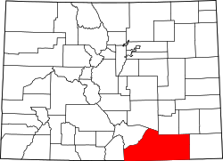
Location of Gulnare, Colorado.
USA Colorado location map.svg
Red pog.svg
Gulnare
Gulnare (Colorado)
Coordinates: 37°19′02″N104°45′07″W / 37.3172°N 104.7519°W / 37.3172; -104.7519 [2]
Country Flag of the United States (23px).png  United States
State Flag of Colorado.svg Colorado
County Las Animas [3]
Elevation
[2]
6,982 ft (2,128 m)
Time zone UTC-7 (MST)
  Summer (DST) UTC-6 (MDT)
GNIS ID 204808

Gulnare (pronounced GUL ner) [1] is an unincorporated community in Las Animas County, Colorado, United States.

Contents

Geography

Gulnare lies southwest of Aguilar and southeast of the Spanish Peaks in the Apishapa River Valley. It is known for The Spanish Peaks Inn, a popular tavern and adjoining RV park. [4]

Name

Originally known as Abeyton, the Abeyton post office operated from March 7, 1884, until August 20, 1890. [5] Residents were promised a new post office, so they sent prospective names in an envelope to the post office's Washington headquarters, but all the names were rejected. The envelope had a drawing of a cow called "Princess of Gulnare". [1]

See also

References

  1. 1 2 3 Bright, William (2004). Colorado place names (3rd ed.). Boulder: Johnson Books. ISBN   1555663338.
  2. 1 2 "Gulnare, Colorado". Geographic Names Information System . United States Geological Survey, United States Department of the Interior . Retrieved December 29, 2024.
  3. "Colorado Counties". Colorado Department of Local Affairs . Retrieved December 29, 2024.
  4. "Gulnare, Colorado". Sangres.com. Retrieved June 16, 2018. There's a couple small businesses in town, the busiest being the Spanish Peaks Inn and RV Park Archived November 13, 2024, at the Wayback Machine
  5. Bauer, William H.; Ozment, James L.; Willard, John H. (1990). Colorado Post Offices 1859–1989. Golden, Colorado: Colorado Railroad Historical Foundation. ISBN   0-918654-42-4.