Starkville, Colorado

Last updated

Starkville, Colorado
Starkville, Colorado.JPG
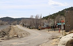
East Railroad Avenue (shown) serves as Starkville's main street.
Las Animas County Colorado Incorporated and Unincorporated areas Starkville Highlighted 0873715.svg
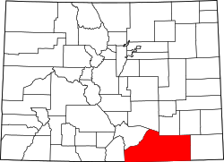
Location of Starkville in Las Animas County, Colorado.
Coordinates: 37°07′01″N104°31′24″W / 37.11694°N 104.52333°W / 37.11694; -104.52333
Country Flag of the United States (23px).png  United States
State Flag of Colorado.svg  Colorado
County [1] Las Animas
Incorporated March 2, 1954 [2]
Named for Albert G. Stark
Government
  Type Statutory Town [1]
Area
[3]
  Total0.07 sq mi (0.19 km2)
  Land0.07 sq mi (0.19 km2)
  Water0.00 sq mi (0.00 km2)
Elevation
[4]
6,355 ft (1,937 m)
Population
 (2020) [5]
  Total62
  Density739.73/sq mi (285.69/km2)
Time zone UTC-7 (Mountain (MST))
  Summer (DST) UTC-6 (MDT)
ZIP code [6]
81082
Area code 719
FIPS code 08-73715
GNIS feature ID2413331 [4]

Starkville is a statutory town in Las Animas County, Colorado, United States. The population was 62 at the 2020 census. [5]

Contents

History

The town was named for Albert G. Stark, a coal mine owner. [7]

The community was formerly a company-owned coal-mining town owned and operated by the Colorado Fuel and Iron Company. On October 8, 1910, an explosion at the Starkville mine killed 56 miners. [8] Exactly a month later, an explosion at the nearby Victor-American Fuel Company mine in Delagua killed 76. Miners from Starkville aided in the recovery efforts. [9]

Geography

According to the United States Census Bureau, the town has a total area of 0.1 square miles (0.26 km2), all of it land. [10] Starkville is 4 mi (6.4 km) south of Trinidad and 8 mi (13 km) from the border with New Mexico at Raton Pass. [11] In the 19th century the Santa Fe Trail passed through the community. Starkville is adjacent to Interstate 25 and the Atchison, Topeka and Santa Fe Railroad.

Demographics

Historical population
CensusPop.Note
1890 928
1960 261
1970 166−36.4%
1980 127−23.5%
1990 104−18.1%
2000 12823.1%
2010 59−53.9%
2020 625.1%
U.S. Decennial Census

2010 census

At the 2010 census, there were 59 people, 26 households, and 30 families living in the town. There were 35 housing units. The racial makeup of the town was 55.9% White, 1.7% Native American, 37.3% from other races, and 3.4% from two or more races. Hispanic or Latino of any race were 72.9% of the population.

Of the 26 households 23.1% had children under the age of 18 living with them, 46.2% were married couples living together, 11.5% had a female householder with no husband present, and 34.6% were non-families. 30.8% of households were one person and 11.5% were one person aged 65 or older. The average household size was 2.27 and the average family size was 2.76.

The age distribution was 22.1% under the age of 19, 6.8% from 20 to 24, 22.1% from 25 to 44, 35.7% from 45 to 64, and 13.6% 65 or older. The median age was 44.5 years.

The median household income was $46,250 and the median family income was $51,250.

2000 census

At the 2000 census there were 128 people, 42 households, and 30 families living in the town. The population density was 1,245.1 inhabitants per square mile (480.7/km2). There were 53 housing units at an average density of 515.6 units per square mile (199.1 units/km2). The racial makeup of the town was 71.88% White, 3.91% Native American, 14.84% from other races, and 9.38% from two or more races. Hispanic or Latino of any race were 64.06%. [12]

Of the 42 households 31.0% had children under the age of 18 living with them, 61.9% were married couples living together, 9.5% had a female householder with no husband present, and 26.2% were non-families. 21.4% of households were one person and 11.9% were one person aged 65 or older. The average household size was 3.05 and the average family size was 3.55.

The age distribution was 27.3% under the age of 18, 10.2% from 18 to 24, 26.6% from 25 to 44, 25.8% from 45 to 64, and 10.2% 65 or older. The median age was 35 years. For every 100 females, there were 96.9 males. For every 100 females age 18 and over, there were 106.7 males.

The median household income was $42,708 and the median family income was $50,000. Males had a median income of $30,417 versus $19,844 for females. The per capita income for the town was $14,297. There were 5.3% of families and 10.1% of the population living below the poverty line, including 18.2% of under eighteens and 22.2% of those over 64.
See also

Related Research Articles

<span class="mw-page-title-main">Otero County, Colorado</span> County in Colorado, United States

Otero County is a county located in the U.S. state of Colorado. As of the 2020 census, the population was 18,690. The county seat is La Junta. The county was named for Miguel Antonio Otero, one of the founders of the town of La Junta and a member of a prominent Hispanic family.

<span class="mw-page-title-main">Las Animas County, Colorado</span> County in Colorado, United States

Las Animas County is a county located in the U.S. state of Colorado. As of the 2020 census, the population was 14,555. The county seat is Trinidad. The county takes its name from the Mexican Spanish name of the Purgatoire River, originally called El Río de las Ánimas Perdidas en el Purgatorio, which means "River of the Lost Souls in Purgatory."

<span class="mw-page-title-main">Brookwood, Alabama</span> City in Alabama, United States

Brookwood is a city in Tuscaloosa County, Alabama, United States. It incorporated in September 1977. As of the 2020 census, the population of the town is 2,504.

<span class="mw-page-title-main">Taylor, Arizona</span> Town in Navaho County, Arizona

Taylor is a town in Navajo County, Arizona, United States. It was founded by Mormon settlers in January 1878, several months before the neighboring community of Snowflake. Taylor straddles Silver Creek, flowing from the nearby White Mountains to the Little Colorado River on Arizona's Colorado Plateau. According to the 2010 census, the population of the town is 4,112. The town was named for John Taylor, the third president of the Church of Jesus Christ of Latter-day Saints.

<span class="mw-page-title-main">Brookside, Colorado</span> Town in Fremont County, Colorado, United States

Brookside is a Statutory Town located in Fremont County, Colorado, United States. The town population was 236 at the 2020 United States Census.

<span class="mw-page-title-main">Aguilar, Colorado</span> Town in Colorado, United States

Aguilar is a Statutory Town located in Las Animas County, Colorado, United States. The town population was 456 at the 2020 United States Census. Cattleman and prominent pioneer José Ramón Aguilar founded the town in 1894.

<span class="mw-page-title-main">Branson, Colorado</span> Town in Colorado, United States

Branson is a Statutory Town located in Las Animas County, Colorado, United States. The town population was 57 at the 2020 United States Census. Branson is the southernmost town in the State of Colorado, located just 0.3 miles (0.48 km) from the New Mexico border.

<span class="mw-page-title-main">Cokedale, Colorado</span> Town in Colorado, United States

Cokedale is a Statutory Town located in Las Animas County, Colorado, United States. The town population was 127 at the 2020 United States Census.

<span class="mw-page-title-main">Manzanola, Colorado</span> Town in Otero County, Colorado, United States

Manzanola is a Statutory Town in Otero County, Colorado, United States. The town population was 341 at the 2020 United States Census.

<span class="mw-page-title-main">Wiley, Colorado</span> Town in Prowers County, Colorado, United States

Wiley is a Statutory Town in Prowers County, Colorado, United States. The population was 437 at the 2020 Census.

<span class="mw-page-title-main">Blue River, Colorado</span> Town in Colorado, United States

Blue River is a Statutory Town located in Summit County, Colorado, United States. The town population was 877 at the 2020 United States Census. The town is located in the Blue River Valley.

<span class="mw-page-title-main">Dacono, Colorado</span> City in Colorado, United States

Dacono is a home rule municipality located in southwestern Weld County, Colorado, United States. The city population was 6,297 at the 2020 United States Census, an increase of +51.66% since the 2010 United States Census. Dacono is a part of the Greeley, CO Metropolitan Statistical Area and the Front Range Urban Corridor.

<span class="mw-page-title-main">Kiowa, Kansas</span> City in Kiowa County, Kansas

Kiowa is a city in Barber County, Kansas, United States. As of the 2020 census, the population of the city was 902. It is located 1 mile north of the Kansas / Oklahoma state border.

<span class="mw-page-title-main">Coolidge, Kansas</span> City in Hamilton County, Kansas

Coolidge is a city in Hamilton County, Kansas, United States. As of the 2020 census, the population of the city was 80. It is located along Highway 50 about 1 mile east of the Colorado-Kansas border.

<span class="mw-page-title-main">Valley Center, Kansas</span> City in Sedgwick County, Kansas

Valley Center is a city in Sedgwick County, Kansas, United States, and a suburb of Wichita. As of the 2020 census, the population of the city was 7,340.

<span class="mw-page-title-main">Marianna, Pennsylvania</span> Borough in Pennsylvania, United States

Marianna is a borough in Washington County, Pennsylvania, United States. The population was 399 at the 2020 census.

<span class="mw-page-title-main">Central City, South Dakota</span> City in South Dakota, United States

Central City is a city in Lawrence County, South Dakota, United States. The population was 93 at the 2020 census.

<span class="mw-page-title-main">Belle, West Virginia</span> Town in West Virginia, United States

Belle is a town in Kanawha County, West Virginia, United States, situated along the Kanawha River. The population was 1,171 at the 2020 census. Belle was incorporated on December 13, 1958, by the Kanawha County Circuit Court. It is the home of the Belle Bulldogs Elementary School.

<span class="mw-page-title-main">Bancroft, West Virginia</span> Town in West Virginia, United States

Bancroft is a town in Putnam County, West Virginia, United States, along the Kanawha River. The population was 389 at the 2020 census. It is part of the Huntington–Ashland metropolitan area.

<span class="mw-page-title-main">Hanna, Wyoming</span> Town in Wyoming, United States

Hanna is a town in Carbon County, Wyoming, United States. The population was 683 at the 2020 census. The town was started as a coal supply location for the Union Pacific Railroad. Much of the old town is built on top of the former workings of the Hanna No. 4 mine. On December 18, 1979, the Town of Hanna annexed the adjacent Town of Elmo. The population peaked at 2,288 in 1980 and has declined as local coal mines have ceased operation.

References

  1. 1 2 "Active Colorado Municipalities". State of Colorado, Department of Local Affairs. Retrieved March 9, 2015.
  2. "Colorado Municipal Incorporations". State of Colorado, Department of Personnel & Administration, Colorado State Archives. December 1, 2004. Retrieved September 2, 2007.
  3. "2019 U.S. Gazetteer Files". United States Census Bureau. Retrieved July 1, 2020.
  4. 1 2 U.S. Geological Survey Geographic Names Information System: Starkville, Colorado
  5. 1 2 United States Census Bureau. "Starkville town; Colorado" . Retrieved April 22, 2023.
  6. "ZIP Code Lookup" (JavaScript/HTML). United States Postal Service . Retrieved March 9, 2015.
  7. "Profile for Starkville, Colorado". ePodunk. Archived from the original on July 1, 2017. Retrieved March 9, 2015.
  8. "1910 Explosion at the Starkville Mine Killed 56 Men". The Denver Post . August 24, 2012. Retrieved February 20, 2020.
  9. "Death at Delagua". World Journal. Huerfano, Las Animas. November 15, 2015. Retrieved February 20, 2020.
  10. "2014 U.S. Gazetteer Files". United States Census Bureau . Retrieved March 9, 2015.
  11. Google Earth
  12. "U.S. Census website". United States Census Bureau . Retrieved March 9, 2015.