Barela, Colorado

Last updated
Barela, Colorado
Usa edcp location map.svg
Red pog.svg
Barela
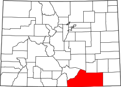
Location of Barela, Colorado.
USA Colorado location map.svg
Red pog.svg
Barela
Barela (Colorado)
Coordinates: 37°06′56″N104°15′42″W / 37.1156°N 104.2616°W / 37.1156; -104.2616 [1]
Country United States
State Colorado
County Las Animas [2]
Government
  Type unincorporated community
  Body Las Animas County [2]
Elevation
[1]
5,761 ft (1,756 m)
Time zone UTC−07:00 (MST)
  Summer (DST) UTC−06:00 (MDT)
GNIS pop ID 194884

Barela is an unincorporated community located in Las Animas County, Colorado, United States. [3]

Contents

History

The Barela, Colorado Territory, post office operated from July 28, 1874, until September 30, 1931. [4] The community is named in honor of Casimiro Barela, a member of the Colorado General Assembly who co-authored the Constitution of Colorado. [5] Colorado became a state on August 1, 1876. [6]

Geography

Barela is located in Las Animas County, Colorado, at coordinates 37°06′56″N104°15′42″W / 37.1156°N 104.2616°W / 37.1156; -104.2616 , at an elevation of 5,761 feet (1,756 m). [1]

See also

References

  1. 1 2 3 "Barela, Colorado". Geographic Names Information System . United States Geological Survey, United States Department of the Interior . Retrieved January 2, 2025.
  2. 1 2 "Colorado Counties". Colorado Department of Local Affairs . Retrieved January 22, 2025.
  3. "Barela Populated Place Profile / Las Animas County, Colorado Data". colorado.hometownlocator.com.
  4. Bauer, William H.; Ozment, James L.; Willard, John H. (1990). Colorado Post Offices 1859–1989. Golden, Colorado: Colorado Railroad Historical Foundation. ISBN   0-918654-42-4.
  5. Dawson, John Frank (1954). Place names in Colorado: why 700 communities were so named, 150 of Spanish or Indian origin. Denver, CO: The J. Frank Dawson Publishing Co. p. 8.
  6. Ulysses S. Grant (August 1, 1876). "Proclamation 230—Admission of Colorado into the Union". The American Presidency Project. Retrieved December 24, 2024.