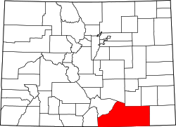
Lynn, Colorado | |
---|---|
Location of the Lynn CDP in the United States. | |
Coordinates: 37°25′19″N104°38′35″W / 37.42194°N 104.64306°W [1] | |
Country | United States |
State | Colorado |
County | Las Animas County |
Government | |
• Type | unincorporated community |
Area | |
• Total | 0.717 sq mi (1.857 km2) |
• Land | 0.717 sq mi (1.857 km2) |
• Water | 0.000 sq mi (0.000 km2) |
Elevation | 6,359 ft (1,938 m) |
Population | |
• Total | 11 |
• Density | 15/sq mi (5.9/km2) |
Time zone | UTC-7 (MST) |
• Summer (DST) | UTC-6 (MDT) |
ZIP Code [4] | Aguilar 81020 |
Area code | 719 |
GNIS feature ID | 2583261 [1] |
Lynn is an unincorporated community and a census-designated place (CDP) located in and governed by Las Animas County, Colorado, United States. The population of the Lynn CDP was 11 at the United States Census 2020. [3] The Aguilar post office (Zip Code 81020) serves the area. [4]
Lynn is in northwestern Las Animas County, 20 miles (32 km) north of Trinidad, the county seat. Interstate 25 passes through the community, with access from Exit 34 (County Road 60). The town of Aguilar is 2 miles (3 km) to the southwest, and Walsenburg is 16 miles (26 km) to the north on I-25.
The Lynn CDP has an area of 459 acres (1.857 km2), all land. [2]
The United States Census Bureau initially defined the Lynn CDP for the United States Census 2010.
Year | Pop. | ±% |
---|---|---|
2010 | 12 | — |
2020 | 11 | −8.3% |
Source: United States Census Bureau |
The Pinery is an unincorporated community and a census-designated place (CDP) located in and governed by Douglas County, Colorado, United States. The CDP is a part of the Denver–Aurora–Lakewood, CO Metropolitan Statistical Area. The population of The Pinery CDP was 11,311 at the United States Census 2020. Douglas County governs the unincorporated community. The Parker post office serves the area.
Westcreek is an unincorporated community and a census-designated place (CDP) located in and governed by Douglas County, Colorado, United States. The CDP is a part of the Denver–Aurora–Lakewood, CO Metropolitan Statistical Area. The population of the Westcreek CDP was 120 at the United States Census 2020. The Sedalia post office serves the area.
Edwards is an unincorporated town, a post office, and a census-designated place (CDP) located in and governed by Eagle County, Colorado, United States. Edwards is the principal town of the Edwards, CO Micropolitan Statistical Area. The Edwards post office has the ZIP Code 81632. At the United States Census 2020, the population of the Edwards CDP was 11,246. The Edwards Metropolitan District provides services.
Ponderosa Park is an unincorporated community and a census-designated place (CDP) located in and governed by Elbert County, Colorado, United States. The CDP is a part of the Denver–Aurora–Lakewood, CO Metropolitan Statistical Area. The population of the Ponderosa Park CDP was 3,334 at the United States Census 2020. Elbert County governs the unincorporated community. The Elizabeth post office serves the area.
Aspen Park is an unincorporated community and a census-designated place (CDP) located in Jefferson County, Colorado, United States. The CDP is a part of the Denver–Aurora–Lakewood, CO Metropolitan Statistical Area. The population of the Aspen Park CDP was 810 at the United States Census 2020. The Aspen Park Metropolitan District provides services. The Conifer post office serves the area.
Leadville North is a census-designated place (CDP) in and governed by Lake County, Colorado, United States. The population of the Leadville North CDP was 1,892 at the United States Census 2020. The Leadville post office serves the area.
Atwood is an unincorporated town, a post office, and a census-designated place (CDP) located in and governed by Logan County, Colorado, United States. The CDP is a part of the Sterling, CO Micropolitan Statistical Area. The Atwood post office has the ZIP Code 80722. At the United States Census 2020, the population of the Atwood CDP was 138.
Padroni is an unincorporated town, a census-designated place (CDP), and a post office located in and governed by Logan County, Colorado, United States. The CDP is a part of the Sterling, CO Micropolitan Statistical Area. The Padroni post office has the ZIP Code 80745. At the United States Census 2020, the population of the Padroni CDP was 75.
Orchard Mesa is a census-designated place (CDP) in and governed by Mesa County, Colorado, United States. It is part of the Grand Junction, CO Metropolitan Statistical Area. The population of the Orchard Mesa CDP was 6,688 at the 2020 census. The Grand Junction post office serves the area.
Hasty is an unincorporated town in Bent County, Colorado, United States.
Hoehne is an unincorporated town, a post office, and a census-designated place (CDP) located in and governed by Las Animas County, Colorado, United States. At the United States Census 2020, the population of the Hoehne CDP was 80.
Weston is an unincorporated town, a post office, and a census-designated place (CDP) located in and governed by Las Animas County, Colorado, United States. The Weston post office has the ZIP Code 81091. At the United States Census 2020, the population of the Weston CDP was 53.
Jansen is an unincorporated community and a census-designated place (CDP) located in and governed by Las Animas County, Colorado, United States. The population of the Jansen CDP was 101 at the United States Census 2020. The Trinidad post office serves the Jansen postal addresses.
Segundo is an unincorporated community and a census-designated place (CDP) located in and governed by Las Animas County, Colorado, United States. The population of the Segundo CDP was 100 at the United States Census 2020. The Trinidad post office serves the area.
Glendale is an unincorporated community and a census-designated place (CDP) located in and governed by Boulder County, Colorado, United States. The CDP is a part of the Boulder, CO Metropolitan Statistical Area. The population of the Glendale CDP was 64 at the United States Census 2020. The Jamestown post office serves the area.
Hidden Lake is an unincorporated community and a census-designated place (CDP) located in and governed by Boulder County, Colorado, United States. The CDP is a part of the Boulder, CO Metropolitan Statistical Area. The population of the Hidden Lake CDP was 24 at the United States Census 2020. The Ward post office serves the area.
Cathedral is a census-designated place (CDP) located in and governed by Hinsdale County, Colorado, United States. The population of the Cathedral CDP was 15 at the United States Census 2020. The Powderhorn post office serves the area.
El Moro is an unincorporated community and a census-designated place (CDP) located in and governed by Las Animas County, Colorado, United States. The population of the El Moro CDP was 216 at the United States Census 2020. The Trinidad post office serves the area.
Stonewall Gap is an unincorporated community and a census-designated place (CDP) located in and governed by Las Animas County, Colorado, United States. The population of the Stonewall Gap CDP was 66 at the United States Census 2020. The Weston post office serves the area.
Valdez is an unincorporated community and a census-designated place (CDP) located in and governed by Las Animas County, Colorado, United States. From 1907 to 1960, Valdez served as a company town for Colorado Fuel & Iron and its Frederick coal mine, the company's most productive and second largest. The population of the Valdez CDP was 46 at the United States Census 2020. The Trinidad post office serves the area.