
Collingham is a village and civil parish in the Newark and Sherwood district, in the county of Nottinghamshire, England. The population of the parish at the 2011 census was 2,738, increasing to 3,052 at the 2021 census.

Averham is a village and civil parish in the Newark and Sherwood district of Nottinghamshire, England. According to the 2001 census it had a population of 187, increasing to 294 at the 2011 census, however Averham alone reported 215 residents at the 2021 census. The village is just west of Newark-on-Trent. Staythorpe Power Station is south-west of the village.

Barnby in the Willows is a village and civil parish in the Newark and Sherwood district of Nottinghamshire, England, just east of Newark-on-Trent. According to the 2001 census it had a population of 244, increasing to 272 at the 2011 census, with a reduction to 255 at the 2021 census. Just to the south of the village is the River Witham, which also forms the border with Lincolnshire here.

Elston is a village and civil parish in the Newark and Sherwood district, in Nottinghamshire, England, to the south-west of Newark, 0.5 mi (800 m) from the A46 Fosse Way. The population of the civil parish taken at the 2011 census was 631, increasing to 697 at the 2021 census. It lies between the rivers Trent and Devon, with the village "set amongst trees and farmland less than a mile from the A46.... Newark is five miles to the north, with... Lincoln and Nottingham some 18 miles north and south-west respectively."

Hawton is a hamlet and civil parish in the Newark and Sherwood district of Nottinghamshire, England. It lies two miles (3.2 km) south of the town of Newark-on-Trent, near the River Devon, a tributary of the River Trent. Its population was recorded as 147 in the 2011 census. Hawton alone reported 80 residents at the 2021 census.

Carlton-on-Trent is a small village and civil parish in England, located between the River Trent and the A1 road near Newark-on-Trent in Nottinghamshire. The population of the civil parish was 228 at the 2001 census, increasing only marginally to 229 at the 2011 census and similarly to 230 at the 2021 census.

East Stoke is a small village and civil parish in Nottinghamshire situated about half a mile to the east of the River Trent and lying about six miles southwest of Newark-upon-Trent. The population of the civil parish (including Thorpe as taken in the 2011 Census was 152, East Stoke alone reported 175 residents at the 2021 census. The A46 Fosse Way ran through East Stoke for many years: cutting the village in two with constant traffic: but since 2012 has been replaced by a new multi-lane A46 which now runs half a mile to the east. East Stoke is thought to have been the site of the Roman settlement of Ad Pontem; the "place of the bridge" – though this is disputed.

Rolleston is a small village and civil parish in Nottinghamshire by the River Greet, a few miles from Southwell not far from the Trent and about 5 miles (8.0 km) southwest of Newark. The population of the civil parish at the 2011 census was 312, increasing to 342 at the 2021 census. It has a church dedicated to the Holy Trinity. It lies close to the railway line between Nottingham and Lincoln with a station serving the village and Southwell as well as the nearby Southwell Racecourse.

Caunton is a village and civil parish in the Newark and Sherwood district of Nottinghamshire on the A616, six miles (9.7 km) north-west of Newark-on-Trent, in the NG23 postcode. The population of the civil parish at the 2011 census was 483, and this increased to 508 at the 2021 census.

Kneesall is a village and civil parish in the East Midlands of England in the county of Nottinghamshire. The population of the civil parish at the 2011 census was 221, increasing slightly to 227 at the 2021 census. Forming part of the Newark and Sherwood district, Kneesall is situated on the A616 road between Newark-on-Trent and Ollerton. The village is three miles from neighbouring Eakring and four miles from Laxton.

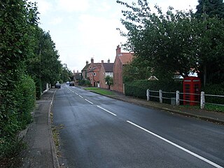
Langford is a village and civil parish in Nottinghamshire, England. It is located four miles north-east of Newark-on-Trent and two miles east from the River Trent. Population for the civil parish was 104 at the 2021 census. It lies along the A1133 which comes off of the A46 road.

Girton is a village and civil parish in Nottinghamshire, England. According to the 2001 census it had a population of 143, reducing slightly to 140 at the 2011 census, and 138 at the 2021 census. It is located 17 miles west of Lincoln.

Halloughton is a hamlet and civil parish in Nottinghamshire, England, 9 miles west of Newark-on-Trent. It lies in the district of Newark and Sherwood. Most of the property there was owned by the Church Commissioners until 1952. The resident population of the parish was 65 at the 2021 census.

Weston is a village and civil parish in Nottinghamshire, England. It is located 10 miles south of Retford. According to the 2001 census it had a population of 312, increasing to 393 at the 2011 census, Weston alone reported 333 residents at the 2021 census. The parish church of All Saints is 13th century. At the south-east end of the village are three 16th century tenements built with cruck trusses.
Caythorpe is a village and civil parish in Nottinghamshire, England. It is situated 10 miles (16 km) north-east from Nottingham, close to the River Trent. According to the 2001 census, it had a population of 259, increasing to 271 at the time of the 2011 census,. and dropping to 257 at the 2021 census.

North Muskham is a village and civil parish in Nottinghamshire, England, close to the border with Lincolnshire. It is located between the River Trent and the A1 road, 3 miles (5 km) north of Newark-upon-Trent. The parish has a population of 943 with around 360 properties, increasing to 985 at the 2011 census, and reducing slightly to 980 at the 2021 census.

North Clifton is a village and civil parish about 12 miles north of Newark-on-Trent, in the Newark and Sherwood district, within the county of Nottinghamshire, England. In 2011, the parish had a population of 216, and this dropped to 176 at the 2021 census. The parish touches Thorney, Fledborough, Newton on Trent, South Clifton and Ragnall.

Thorney is a village and civil parish about 10 miles (16 km) north of Newark-on-Trent, in the Newark and Sherwood district, in the county of Nottinghamshire, England. The settlement is close to the eastern edge of the county. In the census of 2011, the parish had a population of 248, falling to 228 at the 2021 census. A small portion of Drinsey Nook mainly in Lincolnshire falls into the parish to the north, Thorney Moor is a hamlet to the south of the parish area. The parish borders other nearby parishes including Wigsley, Kettlethorpe, Newton on Trent, Saxilby with Ingleby, Harby, North Clifton, South Clifton and Hardwick.

South Clifton is a village and civil parish in the Newark and Sherwood district of Nottinghamshire, England. It is 11 miles north of Newark-on-Trent. With the 2011 census, the parish had a population of 326, this fell to 308 at the 2021 census. The parish touches Thorney, Girton, Fledborough, Wigsley, Marnham, Normanton on Trent, Spalford and North Clifton.
Fiskerton cum Morton is a civil parish in the Newark and Sherwood district, within the county of Nottinghamshire, England. The overall area had a population of 803 at the 2021 census. The parish lies in the south east of the county. It is 112 miles north of London, 12 miles north east of the city of Nottingham, 5 miles west of the town of Newark-on-Trent and 21⁄2 miles south east of the town of Southwell. The parish lies along the bank of the River Trent and is primarily a commuter residential area to both Nottingham and Newark.


