Related Research Articles

Maricopa County is in the south-central part of the U.S. state of Arizona. As of the 2020 census the population was 4,420,568, or about 62% of the state's total, making it the fourth-most populous county in the United States and the most populous county in Arizona, and making Arizona one of the nation's most centralized states. The county seat is Phoenix, the state capital and fifth-most populous city in the United States.

Pinal County is in the central part of the U.S. state of Arizona. According to the 2020 census, the population of the county was 425,264, making it Arizona's third-most populous county. The county seat is Florence. The county was founded in 1875.

Gila Bend, founded in 1872, is a town in Maricopa County, Arizona, United States. The town is named for an approximately 90-degree bend in the Gila River, which is near the community's current location. As of the 2020 census, the population of the town was 1,892.

Sacaton is a census-designated place (CDP) in Pinal County, Arizona, United States. The population was 3,254 at the 2020 census. It is the capital of the Gila River Indian Community.

The Gila River Indian Community (GRIC) is an Indian reservation in the U.S. state of Arizona, lying adjacent to the south side of the cities of Chandler and Phoenix, within the Phoenix Metropolitan Area in Pinal and Maricopa counties. The Gila River Indian Community was established in 1859, and the Gila River Indian Community was formally established by Congress in 1939. The community is home for members of both the Akimel O’odham (Pima) and the Pee-Posh (Maricopa) tribes.

The Salt River is a river in Gila and Maricopa counties in Arizona, United States, that is the largest tributary of the Gila River. The river is about 200 miles (320 km) long. Its drainage basin covers about 13,700 square miles (35,000 km2). The longest of the Salt River's many tributaries is the 195-mile (314 km) Verde River. The Salt's headwaters tributaries, the Black River and East Fork, increase the river's total length to about 300 miles (480 km). The name Salt River comes from the river's course over large salt deposits shortly after the merging of the White and Black Rivers.
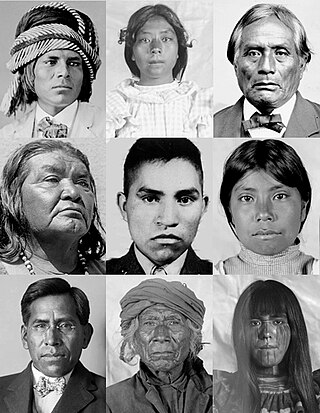
The Akimel O'odham, also called the Pima, are a group of Native Americans living in an area consisting of what is now central and southern Arizona, as well as northwestern Mexico in the states of Sonora and Chihuahua. The majority population of the two current bands of the Akimel O'odham in the United States are based in two reservations: the Keli Akimel Oʼodham on the Gila River Indian Community (GRIC) and the On'k Akimel O'odham on the Salt River Pima-Maricopa Indian Community (SRPMIC).

The Maricopa or Piipaash are a Native American tribe, who live in the Salt River Pima-Maricopa Indian Community and Gila River Indian Community along with the Pima, a tribe with whom the Maricopa have long held a positive relationship. The Maricopa at the Salt River Pima-Maricopa Indian Community consist mostly of Xalychidom Piipaash members and are concentrated in Lehi. The Maricopa at the Gila River Indian Community are concentrated in Maricopa Colony. The Maricopa are a River Yuman group, formerly living along the banks of the Colorado River.

Gila River Indian Reservation was a reservation established in 1859 by the United States government in New Mexico Territory, to set aside the lands of the Akimel O’odham (Pima) and the Piipaash (Maricopa) people along the Gila River, in what is now Pinal County, Arizona. The self-government of the reservation as the Gila River Indian Community was established by Congress in 1939.

Casa Blanca is a census-designated place (CDP) in Pinal County, Arizona, United States, located in the Gila River Indian Community. The population was 1,388 at the 2010 census.
Pima Villages, sometimes mistakenly called the Pimos Villages in the 19th century, were the Akimel O’odham (Pima) and Pee-Posh (Maricopa) villages in what is now the Gila River Indian Community in Pinal County, Arizona. First, recorded by Spanish explorers in the late 17th century as living on the south side of the Gila River, they were included in the Viceroyalty of New Spain, then in Provincias of Sonora, Ostimuri y Sinaloa or New Navarre to 1823. Then from 1824 to 1830, they were part of the Estado de Occidente of Mexico and from September 1830 they were part of the state of Sonora. These were the Pima villages encountered by American fur trappers, traders, soldiers and travelers along the middle Gila River from 1830s into the later 19th century. The Mexican Cession following the Mexican American War left them part of Mexico. The 1853 Gadsden Purchase made their lands part of the United States, Territory of New Mexico. During the American Civil War, they became part of the Territory of Arizona.
Sacaton or Socatoon was a village of the Maricopa people, established above the Pima Villages, after the June 1, 1857, in the Battle of Pima Butte where it appears a few months later in the 1857 Chapman Census. Sacaton village lay on the Gila River, 3.75 miles west of modern Sacaton.
Socatoon Station was a stagecoach station of the Butterfield Overland Mail between 1858 and 1861. It was located four miles (6.4 km) east of Sacaton at a Maricopa village from which it took its name. This station was located 22 miles (35 km) east of Maricopa Wells Station, 11 miles (18 km) east of Casa Blanca Station and 13 miles (21 km) north of Oneida Station.
Arenal, "sandy place" in Spanish, also known as Aranca No.1 in the 1857 census, was one of the 19th century Pima Villages, located along the Gila River, in what is now the Gila River Indian Community in Pinal County, Arizona.
Hormiguero, Spanish for "anthill",, one of the 19th century Pima Villages, was located along the Gila River, in what is now the Gila River Indian Community in Pinal County, Arizona.
El Llano, Spanish for "the plain or open space" or Buen Llano, "good plain", one of the 19th century Pima Villages, was located along the south side of the Gila River, between Sweetwater and Sacaton, in what is now the Gila River Indian Community in Pinal County, Arizona.
Hueso Parado, Spanish for “Standing Bone” or El Juez Tarado Spanish for "The Judge Tarado", was the largest village of the Maricopa people in the 19th century, in what is now the Gila River Indian Community in Pinal County, Arizona.
Agua Raiz, Spanish for "Water root" as named in the 1860 Census, it was one of the 19th century Pima Villages, located along the Gila River, near the modern site of Sacate Village, Arizona in what is now the Gila River Indian Community in Pinal County, Arizona.

Sacate is a populated place in the Middle Gila River Valley area, within Pinal County, Arizona, United States. Located 8 mi (13 km) north of Maricopa on the south side of the Gila River near Pima Butte, Sacate was an Pima village, a railroad station of the Southern Pacific Railroad, and a Catholic mission. It had originally been called Sacaton Station but the name was shortened to its current version in 1904.
Cachanillo was one of the 19th century Pima Villages, located along the Gila River, in what is now the Gila River Indian Community in Pinal County, Arizona.
References
- ↑ G. Bailey, Special Agent Indian Department, Report 77, Report of the Commissioner of Indian Affairs, accompanying the Annual Report of the Secretary of the Interior, For the Year 1858, Wm. A. Harris, Printer, Washington, 1858, pp. 202–08. A report about the Indians of the so called Territory of Arizona, including census tables of the Maricopas, Pimas and Papagos furnished by Lieutenant A. B. Chapman, First Dragoons, U. S. Army.
- ↑ Wilson, John P. (July 1999) [1998]. "Peoples of the Middle Gila: A Documentary History of the Pimas and Maricopas, 1500's - 1945" (PDF). Baja Arizona History. p. 153-4. Archived (PDF) from the original on May 16, 2024. Retrieved May 16, 2024.
Municipalities and communities of Pinal County, Arizona, United States | ||
|---|---|---|
| Cities |  | |
| Towns | ||
| CDPs |
| |
| Populated places | ||
| Indian reservations | ||
| Ghost towns | ||
| Footnotes | ‡This populated place also has portions in an adjacent county or counties | |