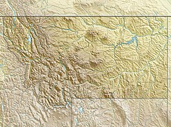
Big Horn County is a county in the U.S. state of Montana. As of the 2010 United States Census, the population was 12,865. The county seat is Hardin. The county, like the river and mountain range, were named for the bighorn sheep in the Rocky Mountains. The county was founded in 1913. It is located on the south line of the state.

Crow Agency is a census-designated place (CDP) in Big Horn County, Montana, United States and is near the actual location for the Little Bighorn National Monument and re-enactment produced by the Real Bird family known as Battle of the Little Bighorn Reenactment. The population was 1,616 at the 2010 census. It is the governmental headquarters of the Crow Native Americans. It is also the location of the "agency offices" where the federal Superintendent of the Crow Indian Reservation and his staff interacts with the Crow Tribe, pursuant to federal treaties and statutes.

The Absaroka Range is a sub-range of the Rocky Mountains in the United States. The range stretches about 150 mi (240 km) across the Montana-Wyoming border, and 75 miles at its widest, forming the eastern boundary of Yellowstone National Park along Paradise Valley (Montana), and the western side of the Bighorn Basin. The range borders the Beartooth Mountains to the north and the Wind River Range to the south. The northern edge of the range rests along I-90 and Livingston, Montana. The highest peak in the range is Francs Peak, located in Wyoming at 13,153 ft (4,009 m). There are 46 other peaks over 12,000 ft (3,700 m).

The Little Bighorn River is a 138-mile-long (222 km) tributary of the Bighorn River in the United States in the states of Montana and Wyoming. The Battle of the Little Bighorn, also known as the Battle of the Greasy Grass, was fought on its banks on June 25th and 26th, 1876, as well as the Battle of Crow Agency in 1887.

The Bighorn Mountains are a mountain range in northern Wyoming and southern Montana in the United States, forming a northwest-trending spur from the Rocky Mountains extending approximately 200 miles (320 km) northward on the Great Plains. They are separated from the Absaroka Range, which lie on the main branch of the Rockies in western Wyoming, by the Bighorn Basin. Much of the land is contained within the Bighorn National Forest.

A pyramidal peak, sometimes called a glacial horn in extreme cases, is an angular, sharply pointed mountain peak which results from the cirque erosion due to multiple glaciers diverging from a central point. Pyramidal peaks are often examples of nunataks.

The Anaconda-Pintler Wilderness is located in southwestern Montana, in the northwestern United States. It runs for 40 miles (65 km) along both sides of the crest of the Anaconda Range, covering almost 250 square miles (640 km2). To the north are the Sapphire Mountains, and to the south is the Big Hole Valley. Elevations range from about 5000 feet up to 10,793 feet at West Goat Peak. West Pintler Peak, located in a more commonly visited area, rises to 9894 feet. Visitors can most easily access this area via trailheads at Pintler Lake to the south, and at Lutz Creek and Moose Lake to the north. The wilderness lies in parts of Deer Lodge, Granite, Ravalli, and Beaverhead counties.
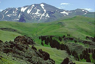
Francs Peak is the highest point in the Absaroka Range which extends from north central Wyoming into south central Montana, in the United States. It is in the Washakie Wilderness of Shoshone National Forest, and the peak is also the highest point in Park County, Wyoming, which include many of Yellowstone National Park. It was named after Otto Franc, a cattle baron and homesteader in the Big Horn Basin.

The Bears Paw Mountains are an insular-montane island range in North-Central Montana, USA, located approximately 10 miles south of Havre, Montana. Baldy Mountain, which rises 6,916 feet above sea level, is the highest peak in the range.

The Elkhorn Mountains are a mountain range in southwestern Montana, part of the Rocky Mountains and are roughly 300,000 acres (1200 km²) in size. It is an inactive volcanic mountain range with the highest point being Crow Peak at 9,414 ft (2,869 m), right next to Elkhorn Peak, 9,381 ft (2,859 m). The range is surrounded by the cities of Helena, Montana City, Townsend, Whitehall, and Boulder and is part of the Helena National Forest in Montana's Jefferson County.
Bighorn most often refers to the bighorn sheep. Big Horn or Bighorn might also mean:

The Flathead Range is a mountain range of the Northern Rocky Mountains located south-east of Whitefish, Montana in the Great Bear Wilderness, part of the Bob Marshall Wilderness Complex. It is east of the Swan Range and southeast of the Whitefish Range. Its west side is drained by the South Fork Flathead River which forms Hungry Horse Reservoir.
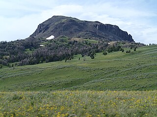
The Wolf Mountains, el. 4,842 feet (1,476 m), sometimes referred to by local people as the Rosebud Mountains, and also known to the Crow Indians as the Wolf Teeth Mountains, are a mountain range east of Lodge Grass, Montana in Big Horn County, Montana.
The Gravelly Range, highest peak Black Butte, el. 10,542 feet (3,213 m), is a mountain range southwest of Cameron, Montana in Madison County, Montana.

The Highland Mountains, highest point Table Mountain, el. 10,223 feet (3,116 m), are a small mountain range southwest of Whitehall, Montana in Silver Bow and Madison County, Montana.
The Little Wolf Mountains, el. 4,800 feet (1,500 m), is a small mountain range southwest of Colstrip, Montana in Big Horn County, Montana.

The Regional designations of Montana vary widely within the U.S state of Montana. The state is a large geographical area that is split by the Continental Divide, resulting in watersheds draining into the Pacific Ocean, Gulf of Mexico and Hudson's Bay. The state is approximately 545 miles (877 km) east to west along the Canada–United States border and 320 miles (510 km) north to south. The fourth largest state in land area, it has been divided up in official and unofficial ways into a variety of regions. Additionally, Montana is part of a number of larger federal government administrative regions.