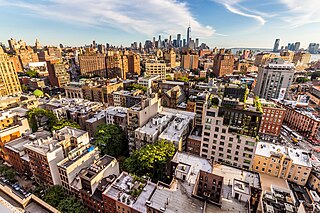
Greenwich Village is a neighborhood on the west side of Lower Manhattan in New York City, bounded by 14th Street to the north, Broadway to the east, Houston Street to the south, and the Hudson River to the west. Greenwich Village also contains several subsections, including the West Village west of Seventh Avenue and the Meatpacking District in the northwest corner of Greenwich Village.

The Cree are a North American Indigenous people. They live primarily in Canada, where they form one of the country's largest First Nations.
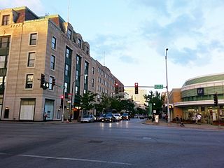
Oak Park is a village in Cook County, Illinois, adjacent to Chicago. It is the 29th-most populous municipality in Illinois with a population of 54,583 as of the 2020 U.S. Census estimate. Oak Park was first settled in 1835 and later incorporated in 1902, when it separated from Cicero. Architect Frank Lloyd Wright and his wife settled in Oak Park in 1889, and his work heavily influenced local architecture and design, including the Frank Lloyd Wright Home and Studio. Over the years, rapid development was spurred by railroads and street cars connecting the village to jobs in nearby Chicago. In 1968, Oak Park passed the Open Housing Ordinance, which helped devise strategies to integrate the village rather than resegregate.

Algonquin is a village in McHenry and Kane counties, Illinois, in the United States. It is a suburb of Chicago, located approximately 40 miles (64 km) northwest of the Loop. As of the 2020 census, the village's population was 29,700.
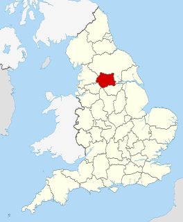
West Yorkshire is a metropolitan and ceremonial county in England. It is an inland and, in relative terms, upland county having eastward-draining valleys while taking in the moors of the Pennines. West Yorkshire came into existence as a metropolitan county in 1974 after the passage of the Local Government Act 1972 and has a population of 2.3 million. Its largest settlements are Leeds, Bradford, Huddersfield, Wakefield, Halifax, Keighley and Dewsbury.

The Monongahela culture were an Iroquoian Native American cultural manifestation of Late Woodland peoples from AD 1050 to 1635 in present-day western Pennsylvania, western Maryland, eastern Ohio, and West Virginia. The culture was named by Mary Butler in 1939 for the Monongahela River, whose valley contains the majority of this culture's sites.
Seneca Village was a 19th-century settlement of mostly African American landowners in the borough of Manhattan in New York City, within what would become present-day Central Park. The settlement was located near the current Upper West Side neighborhood, approximately bounded by Central Park West and the axes of 82nd Street, 89th Street, and Seventh Avenue, had they been constructed through the park.

Somerset West is a town in the Western Cape, South Africa. Organisationally and administratively it is included in the City of Cape Town metropolitan municipality as a suburb of the Helderberg region . The vehicle registration code for Somerset West is CFM and the post code is 7130 for street addresses, and 7129 for post office boxes.
The administrative divisions of India are subnational administrative units of India; they are composed of a nested hierarchy of administrative divisions.

The West Village is a neighborhood in the western section of the larger Greenwich Village neighborhood of Lower Manhattan, New York City.

West Village is a historic district roughly bounded by Jefferson, Kercheval, Parker, and Seyburn Avenues in Detroit, Michigan. Adjacent to the west is the Islandview neighborhood, and adjacent to the east is Indian Village. The district received its name in the mid 20th century because of its location just west of the more well-known Indian Village Historic District. It was listed on the National Register of Historic Places in 1980.
Mathurapur I is a community development block that forms an administrative division in Diamond Harbour subdivision of South 24 Parganas district in the Indian State of West Bengal.
Mandirbazar is a community development block that forms an administrative division in Diamond Harbour subdivision of South 24 Parganas district in the Indian State of West Bengal.
Bishnupur I is a community development block that forms an administrative division in the Alipore Sadar subdivision of the South 24 Parganas district in the Indian state of West Bengal.
Gosaba is a community development block that forms an administrative division in Canning subdivision of South 24 Parganas district in the Indian State of West Bengal.
Falta is a community development block that forms an administrative division in the Diamond Harbour subdivision of the South 24 Parganas district in the Indian state of West Bengal.
Diamond Harbour I is a community development block that forms an administrative division in Diamond Harbour, Diamond Harbour subdivision of the South 24 Parganas district in the Indian state of West Bengal.
Diamond Harbour II is a community development block that, together with Diamond Harbour I, forms an administrative division in the Diamond Harbour, Diamond Harbour subdivision of the South 24 Parganas district in the Indian state of West Bengal.
Sagar is a community development block that forms an administrative division in Kakdwip subdivision of South 24 Parganas district in the Indian State of West Bengal.
The 2017 Western Nineveh offensive, code-named Operation Muhammad, Prophet of God, was launched by the Iraqi Popular Mobilization Forces (PMF) against the Islamic State of Iraq and the Levant (ISIL) in the western Nineveh province of northern Iraq in late April 2017.

