
The 1986 Pacific hurricane season featured several tropical cyclones that contributed to significant flooding to the Central United States. The hurricane season officially started May 15, 1986, in the eastern Pacific, and June 1, 1986 in the central Pacific, and lasted until November 30, 1986 in both regions. These dates conventionally delimit the period of each year when most tropical cyclones form in the northeastern Pacific Ocean. A total of 17 named storms and 9 hurricanes developed during the season; this is slightly above the averages of 15 named storms and 8 hurricanes, respectively. In addition, 26 tropical depressions formed in the eastern Pacific during 1986, which, at the time, was the second most ever recorded; only the 1982 Pacific hurricane season saw a higher total.
The 1985 Pacific hurricane season is the third-most active Pacific hurricane season on record. It officially started on May 15, 1985, in the eastern Pacific, and on June 1, 1985, in the central Pacific, and lasted until November 30, 1985. These dates conventionally delimit the period of each year when most tropical cyclones form in the northeastern Pacific Ocean. At the time, the 1985 season was the most active on record in the eastern north Pacific, with 28 tropical cyclones forming. Of those, 24 were named, 13 reached hurricane intensity, and 8 became major hurricanes by attaining Category 3 status or higher on the Saffir–Simpson scale. At that time, the 24 named storms was a record; however, this record was broken seven years later in 1992, and was therefore recognized as the second busiest season within the basin, until it was surpassed exactly thirty years later by the 2015 season.

The 1983 Pacific hurricane season was the longest season ever recorded at that time. It was a very active Pacific hurricane season. The season started on May 15, 1983 in the eastern Pacific, and on June 1, 1983 in the central Pacific, and lasted until November 30, 1983. These dates conventionally delimit the period of each year when most tropical cyclones form in the northeastern Pacific Ocean. During the 1983 season, there were 20 named storms, which was slightly less than the previous season. Furthermore, twelve of those storms became hurricanes. And eight of the storms reached major hurricane status, or Category 3 or higher on the Saffir–Simpson hurricane wind scale (SSHWS). The decaying 1982–83 El Niño event likely contributed to this level of activity. That same El Niño influenced a very quiet Atlantic hurricane season.

Hurricane Marty was a Category 2 Pacific hurricane that caused extensive flooding and damage in northwestern Mexico just weeks after Hurricane Ignacio took a similar course. Marty was the thirteenth named storm, fourth hurricane, and the deadliest tropical cyclone of the 2003 Pacific hurricane season. Forming on September 18, it became the 13th tropical storm and fourth hurricane of the year. The storm moved generally northwestward and steadily intensified despite only a marginally favorable environment for development, and became a Category 2 hurricane before making two landfalls on the Baja California peninsula and mainland Mexico.

Tropical Storm Norma was the fourteenth named tropical cyclone of the 1970 Pacific hurricane season. The storm formed off the coast of Mexico and intensified rapidly, peaking as a strong tropical storm on September 3, before starting a weakening trend. It dissipated before making landfall on Baja California.

Hurricane Tico is one of four major hurricanes to ever strike Mazatlan and one of the strongest landfalling Pacific hurricanes on record. Tico was the twenty-third tropical cyclone, nineteenth named storm, eleventh hurricane, and eighth major hurricane of the 1983 Pacific hurricane season. The origins of Hurricane Tico were a weak tropical disturbance that crossed Costa Rica into the Pacific Ocean on October 7, 1983. Over warm waters, the system was sufficiently organized to be declared Tropical Depression Twenty-One on October 11, about 575 mi (925 km) south of Acapulco. On October 12 it turned sharply northward; the depression was upgraded to Tropical Storm Tico on October 13. Tropical Storm Tico continued to intensify. Two days after becoming a tropical storm, Tico strengthened further to attain hurricane status. Early on October 19, it reached peak winds of 130 mph (210 km/h). It weakened slightly as it approached the coast, and at about 1500 UTC that day Tico made landfall near Mazatlán with winds of 125 mph (205 km/h). The remains were tracked into the Mid-Atlantic States for five more days.

Hurricane Isis was the only hurricane to make landfall during the 1998 Pacific hurricane season. The ninth tropical storm and sixth hurricane of the season, Isis developed on September 1 from an interaction between a tropical wave and a large surface circulation to the southwest of Mexico. It moved northward, striking the extreme southeastern portion of the Baja California peninsula before attaining hurricane status in the Gulf of California. Isis made landfall at Topolobampo in the Mexican state of Sinaloa on September 3, and quickly lost its low-level circulation. The remnants persisted for several days before dissipating over the U.S. state of Idaho on September 8.
Hurricane Lester was the first Pacific tropical cyclone to enter the United States as a tropical storm since 1967. The fourteenth named storm and eighth hurricane of the 1992 Pacific hurricane season, Lester formed on August 20 from a tropical wave southwest of Mexico. The tropical storm moved generally northwestward while steadily intensifying. After turning to the north, approaching the Mexican coast, Lester attained hurricane status. The hurricane reached peak winds of 85 mph (137 km/h) before making landfall on west-central Baja California. The system weakened while moving across the peninsula and then over northwestern Mexico. Not long after entering Arizona, Lester weakened to a tropical depression, and degenerated into an extratropical low on August 24, 1992, over New Mexico. The storm's remnants later merged with the remnants of Hurricane Andrew and another frontal system on August 29.
Tropical Storm Lowell was a moderate tropical storm that developed during the 2008 Pacific hurricane season. The fourteenth tropical cyclone and thirteen named storm of the season, Lowell formed out of a western side of a trough on September 6. It quickly intensified into Tropical Storm Lowell, peaking as a moderate tropical storm. It pass directly over Socorro Island and began a weakening trend. It weakened into depression before landfall in Baja California Sur and dissipated before striking Sonora. It later joined with a frontal boundary and Hurricane Ike which caused severe damage as far inland as Chicago. In all, the storm had caused 6 deaths and $15.5 million damage.

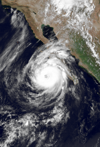
Hurricane Jimena is tied with Hurricane Norbert as the strongest tropical cyclone to make landfall on western portion of the Baja California Peninsula. Jimena was the twelfth named storm, fifth hurricane, third major hurricane and overall second-strongest tropical cyclone of the 2009 Pacific hurricane season. Forming from a tropical wave late on August 28, 2009, off of Mexico's Pacific coast, the system rapidly intensified into a Category 2 hurricane on the next day. Two days after developing, Jimena strengthened into a Category 4 hurricane. After peaking close to Category 5 intensity on September 1, it encountered cold water and began to weaken. When the hurricane made landfall on the Baja California Peninsula on September 3, it was only a Category 2 hurricane. On the next day, the tropical cyclone entered the Gulf of California, though the storm weakened into a remnant low after looping back eastward towards Baja California. The storm's remnants drifted westward into the Pacific afterward, before dissipating on September 8.
Tropical Storm Rachel was the only tropical cyclone to make landfall during the 1990 Pacific hurricane season. The twenty-fourth tropical depression and eighteenth named storm, Rachel developed on September 27 from a tropical wave southwest of mainland Mexico. After becoming a tropical depression, the system tracked slowly southwestward and eventually curved northwestward. The depression intensified into a tropical storm after three days and was named Rachel by the National Hurricane Center. Rachel continued to steadily strengthen, and peaked as a strong 65 mph (100 km/h) tropical storm on October 2. After attaining peak intensity, Rachel re-curved to make a landfall in southern Baja California Sur and again in the Mexican Mainland on October 3. The storm produced heavy rainfall across northern Mexico and the Southwestern United States. Thousands of people were left homeless and 18 fatalities were reported.

Tropical Storm Lidia was the deadliest tropical cyclone of the 1981 Pacific hurricane season. On October 6, a tropical depression formed and strengthened into a tropical storm six hours later. Lidia brushed the southern tip of the Mexican state of Baja California Sur and made landfall just south of Los Mochis in Sinaloa on October 8 as a mid-level tropical storm. Once onshore, Tropical Storm Lidia rapidly weakened and dissipated the same day. It inflicted heavy rain and flooding throughout parts of northwestern Mexico, especially Sinaloa. Overall, Lidia killed 100 people and caused at least $80 million in damage.

Hurricane Doreen was considered the worst tropical cyclone to affect California in 32 years. The tenth tropical cyclone, fourth named storm, and second hurricane of the otherwise inactive 1977 Pacific hurricane season, it developed on August 13. The depression tracked northwestward, intensifying into Tropical Storm Doreen later that day. Further strengthening occurred over the subsequent days, and Doreen attained its peak as a minimal hurricane early on August 15. Executing a turn towards the north-northwest, Doreen made its first landfall as a Category 1 hurricane on the Saffir–Simpson Hurricane Wind Scale near Puerto San Carlos. Drifting offshore, Doreen made a second and final landfall near the northern portion of the Baja California as a tropical storm before rapidly weakening to a tropical depression. The tropical depression dissipated south of southern California on August 18.
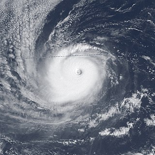
Hurricane Norbert marked the first time a core of a hurricane was fully mapped in three-dimensions. First forming on September 14, 1984 west of the Mexican coast, Norbert gradually intensified, reaching hurricane intensity two days after formation. On September 22, Norbert peaked in strength as a Category 4 hurricane on the Saffir-Simpson Hurricane Scale. While intensifying, Norbert meandered. It moved east, then north, then west, then south, then back towards the east, and finally towards the northeast. After fluctuating in intensity for two more days, Norbert rapidly weakened. It turned towards the northwest and made landfall in southern Baja California Norte as a tropical storm. The combination of Norbert and several other storms left thousands homeless throughout Mexico. The remnants of Hurricane Norbert produced moderate rain over Arizona.

Hurricane Joanne was one of four tropical cyclones to bring gale-force winds to the Southwestern United States in the 20th century. A tropical depression developed on September 30, 1972. It then moved west northwest and intensified into a hurricane on October 1. Hurricane Joanne peaked as a Category 2 hurricane, as measured by the modern Saffir-Simpson hurricane wind scale (SSHWS), October 2. Joanne then slowed and began to re-curve. Joanne made landfall along the northern portion of the Baja California Peninsula as a tropical storm. The tropical storm moved inland over Sonora on October 6 and was believed to have survived into Arizona as a tropical storm. In Arizona, many roads were closed and some water rescues had to be performed due to a prolonged period of heavy rains. One person was reportedly killed while another was electrocuted. A few weeks after the hurricane, Arizona would sustain additional flooding and eight additional deaths.

Hurricane Ramon was a very intense Pacific hurricane whose remnants generated heavy rains in Southern California. The 19th named storm and final hurricane of the above-average 1987 Pacific hurricane season, Ramon originated from a tropical disturbance that formed in early October. On October 5, a tropical storm had developed several hundred miles southwest of Manzanillo, bypassing the tropical depression stage. Tropical Storm Ramon turned to the west-northwest after initially moving west. It intensified into a hurricane on October 7. Two days later, Hurricane Ramon peaked in intensity with winds of 140 mph (220 km/h). After peaking, Ramon turned to the northwest and rapidly weakened over cooler waters. It weakened into a tropical storm on October 11 and a depression on October 12. Ramon dissipated shortly thereafter. While at sea, Ramon brought light rainfall to the Baja California Peninsula. The remnants of Hurricane Ramon produced heavy rainfall that caused flooding in California, indirectly contributing to five traffic-related fatalities. Rainfall was reported as far inland as Utah.


