Related Research Articles

The Kingdom of the East Saxons, referred to as the Kingdom of Essex, was one of the seven traditional kingdoms of the Anglo-Saxon Heptarchy. It was founded in the 6th century and covered the territory later occupied by the counties of Essex, Middlesex, much of Hertfordshire and west Kent. The last king of Essex was Sigered of Essex, who in 825 ceded the kingdom to Ecgberht, King of Wessex.

Eadwig was King of England from 23 November 955 until his death in 959. He was the elder son of Edmund I and his first wife Ælfgifu, who died in 944. Eadwig and his brother Edgar were young children when their father was killed trying to rescue his seneschal from attack by an outlawed thief on 26 May 946. As Edmund's sons were too young to rule he was succeeded by his brother Eadred, who suffered from ill health and died unmarried in his early 30s.

Edgar was King of England from 959 until his death in 975. He was the younger son of King Edmund I and his first wife Ælfgifu. Edmund was killed in 946 trying to protect his seneschal from attack by an outlaw, and because his children were infants he was succeeded by his younger brother Eadred, who ruled until his death in 955. Edgar's older brother, Eadwig, then became king and in 957 the kingdom was divided, Eadwig ruling south of the Thames and Edgar north of it. Historians disagree whether this was the result of a revolt by Edgar's supporters against Eadwig's incompetent rule or had been previously agreed. Edgar became king of all England on his brother's death in 959. A detailed account of Edgar's reign is not possible, because only a few events were recorded by chroniclers and monastic writers were more interested in recording the activities of the leaders of the church.
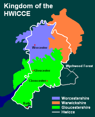
Hwicce was a tribal kingdom in Anglo-Saxon England. According to the Anglo-Saxon Chronicle, the kingdom was established in 577, after the Battle of Deorham. After 628, the kingdom became a client or sub-kingdom of Mercia as a result of the Battle of Cirencester.

The Diocese of Worcester forms part of the Church of England (Anglican) Province of Canterbury in England.
White Ladies Aston is a village in the Wychavon local government district of Worcestershire, England, United Kingdom, and also lends its name to the civil parish in which the village is located. The village is located to the east of the A44 which started as a Saltway linking Droitwich to Oxford. To the south is Pershore and five miles west is Worcester. The parish is bound to the east by the Bow Brook. The parish, according to the 2011 census, has 87 households with 220 residents.
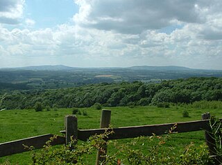
Shatterford Hill is an English geographical feature that extends from Bewdley in north Worcestershire to Birdsgreen near Alveley, just over the border in Shropshire. The hill is a long ridge running up the east side of the Severn Valley and peaks at 202 metres near the village of Shatterford on the A442 road between Kidderminster and Bridgnorth.
Anglo-Saxon charters are documents from the early medieval period in England which typically made a grant of land or recorded a privilege. The earliest surviving charters were drawn up in the 670s: the oldest surviving charters granted land to the Church, but from the eighth century, surviving charters were increasingly used to grant land to lay people.

Trimpley is a hamlet in the parish of Kidderminster Foreign. It lies on the ridge of Shatterford Hill, north of Wribbenhall and east of Habberley. The village lies along Trimpley Green, a small common. At the northern end of Trimpley is the ancient wooded area of Eymore Wood, now bounded on its west by the Severn Valley Railway, beyond which lies Trimpley Reservoir.

Cookley is a village in the Wyre Forest District of Worcestershire, England, a few miles to the north of Kidderminster, and close to the villages of Kinver and Wolverley. It lies on the River Stour, and the Staffordshire and Worcestershire Canal in the civil parish of Wolverley and Cookley. At the time of the 2001 census had a population of 2,491.

The Ismere Diploma is a charter of 736, in which Aethelbald of Mercia grants ten hides of land near Ismere to Cyneberht, his "venerable companion", for the foundation of a coenubium (minster).

Conderton is a small hamlet in the Wychavon district of Worcestershire, England.
The Tomsaete or Tomsæte were a tribe or clan in Anglo-Saxon England living in the valley of the River Tame in the West Midlands of England from around 500 and remaining around Tamworth throughout the existence of the Kingdom of Mercia. The tribe was identified as Anglian Mercens who came from the north, following the Trent Valley, and eventually settling along the valleys of the Tame.
The Stoppingas was a tribe or clan of Anglo-Saxon England. Their domain was Wootton Wawen and the valley of the River Alne in modern-day Warwickshire. The name of the tribe may have come from the personal name Stoppa, who could have been the tribe's founder or leader, or earliest common ancestor.
Morfe Forest was a medieval royal forest in east Shropshire.
The Pencersæte were a tribe or clan in Anglo-Saxon England. They lived in the valley of the River Penk in the West Midlands, and remained around Penkridge throughout the existence of the Kingdom of Mercia.
The Battle of Hehil was a battle won by a force of Britons, probably against the Anglo-Saxons of Wessex around the year 720. The location is unknown, except that it was apud Cornuenses.
Regiones or provinciae,(singular: provincia), also referred to by historians as small shires or early folk territories, were early territorial divisions of Anglo-Saxon England, referred to in sources such as Anglo-Saxon charters and the writings of Bede. They are likely to have originated in the years before 600, and most evidence for them occurs in sources from or about the 7th century.
The Limenwara or Limenware were a people of Anglo-Saxon England whose territory formed a regio or early administrative subdivision of the Kingdom of Kent. The name means "Limen-dwellers", with "Limen" being the name of the former eastern arm of the River Rother, which at that time entered the sea at Lympne.
Della Hooke, is a British historical geographer and academic, who specialises in landscape history and Anglo Saxon England.
References
- ↑ Kirby, D. P. (2002). The Earliest English Kings. Routledge. ISBN 9781134548132.
- 1 2 Rumble, Alexander R. (2012). Leaders of the Anglo-Saxon Church: From Bede to Stigand. Woodbridge: Boydell Press. p. 87. ISBN 9781843837008.
- ↑ Wood, Michael (2011). The Domesday Quest: In search of the Roots of England. BBC Books. p. 78. ISBN 978-0563522744.
- ↑ Rippon, Stephen (2012). Making Sense of an Historic Landscape. Oxford: Oxford University Press. p. 187. ISBN 9780199533787.
- 1 2 Victoria County History, Worcestershire III
- ↑ D. Hooke, Worcestershire Anglo-Saxon Charter-bounds (Boydell, Woodbridge, 1990), 61-3.
- 1 2 Hooke, Della (1990). Worcestershire Anglo-Saxon Charter Bounds. Woodbridge: The Boydell Press. p. 63. ISBN 0851152767.
- ↑ D. Hooke, Worcestershire Anglo-Saxon Charter-bounds, 169-74.
- ↑ P. W. King, 'The minster aet Sture in Husmere and the northern boundary of the Hwicce' Transactions of Worcestershire Archaeological Society 3rd ser. 15 (1996), 73-4.
- ↑ John Blair, The Church in Anglo-Saxon Society (New York, Oxford University Press, 2005).
- ↑ Barrow, Julia; Wareham, Andrew (2008). Myth, Rulership, Church and Charters: Essays in Honour of Nicholas Brooks. Burlington, VT: Ashgate Publishing, Ltd. p. 83. ISBN 9780754651208.
| | This article related to the history of England is a stub. You can help Wikipedia by expanding it. |